Decatur metropolitan area, Alabama facts for kids
Quick facts for kids
Decatur metropolitan area, Alabama
|
|
|---|---|
|
Statistical Area
|
|

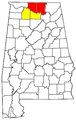
Decatur Metropolitan Statistical Area is shaded in yellow. Decatur MSA is part of the Huntsville-Decatur CSA (shown in yellow and red).
|
|
| State | Alabama |
| Area | |
| • Total | 3,411 km2 (1,317 sq mi) |
| Population
(2020)
|
|
| • Total | 152,740 |
| • Density | 44.779/km2 (115.976/sq mi) |
| Time zone | CST |
The Decatur, Alabama Metropolitan Statistical Area is a busy region in North-Central Alabama. Think of it as a big neighborhood that includes the city of Decatur, Alabama and the towns and areas around it.
In 2020, about 152,740 people lived here. About one-third of these people live right in the city of Decatur. This area is also part of a larger region called the Huntsville-Decatur CSA. This bigger area includes other important cities like Huntsville and Madison.
Contents
Cities and Towns in the Decatur Area
The Decatur Metropolitan Area includes several cities and towns. These places are important parts of the region.
Main Cities
These are the biggest and most important cities in the area:
- Decatur
- Hartselle
- Moulton
- Huntsville (Even though Huntsville has its own big area, some of its land is in Morgan County, which is part of the Decatur area.)
Other Towns to Explore
There are also many other towns and communities that make up this metropolitan area:
Smaller Communities
Many smaller, unincorporated communities are also part of the Decatur area. These places don't have their own city governments but are still home to many people.
- Burningtree Mountain
- Caddo
- Cotaco
- Danville
- Five Points
- Flint
- Florette
- Hatton
- Hulaco
- Lacey's Spring
- Landersville
- Mallard Creek
- Morgan City
- Moulton Heights
- Mount Hope
- Neel
- Oakville
- Pittsburg
- Punkin Center
- Red Bank
- Ryan Crossroads
- Speake
- Tanner
- Valhermoso Springs
- Wheeler
- Wren
Getting Around: Major Highways
Several important highways help people travel through the Decatur Metropolitan Area. These roads connect cities and towns and are key for transportation.
This major highway enters the area near Lacon. It goes north through Hartselle. Then, it crosses the Tennessee River on a long bridge, connecting Morgan County and Limestone County. After the bridge, you can find exits for Huntsville and Decatur.
This highway also starts near Lacon and heads north. It passes through Hartselle and then enters Decatur. In Decatur, it gives access to places like Decatur High School and the Cooks Natural Science Museum. It leaves the area by crossing the Captain William J. Hudson "Steamboat Bill" Memorial Bridges into Limestone County.
This road comes into Decatur from Limestone County. It crosses the Tennessee River on the same bridge as US 31. It then goes through the industrial part of Decatur. Important companies like United Launch Alliance (which builds rockets for NASA) are located along this route. This highway eventually leaves the area as it heads towards The Shoals.
This highway enters the area from southern Huntsville. It crosses the Tennessee River, connecting Madison and Morgan Counties. It then continues south towards the Gadsden area.
Similar to Alt US 72, this route enters Decatur from Limestone County. It also crosses the Tennessee River on the Captain William J. Hudson "Steamboat Bill" Memorial Bridges. It passes through the industrial areas of Decatur, where companies like United Launch Alliance are found. This highway also leaves the area as it goes into Colbert County.
This route starts near Hulaco and goes to Somerville. It passes through Priceville and enters Decatur near I-65. In Decatur, part of it is known as the Beltline, which helps reduce traffic. It ends where it meets Alt US 72 and State Route 20 in Decatur.

