
Deep Notch facts for kids
Quick facts for kids Deep Notch |
|
|---|---|

View north into notch
|
|
| Elevation | 1,900 ft (579 m) |
| Traversed by | |
| Location | Lexington, New York, US |
| Range | Catskills |
| Coordinates | 42°11′40″N 74°24′20″W / 42.19444°N 74.40556°W |
Deep Notch is a special place in the Catskill Mountains in Lexington, New York. It's like a big, narrow groove or gap between two tall mountains. Sometimes people call it West Kill Notch or Echo Notch.
This amazing natural feature is important for a few reasons. A state road, NY 42, goes right through it. Also, the Shandaken Tunnel, which is part of the New York City water supply system, runs underneath. People have described Deep Notch as "striking" and "a marvel of grandeur and beauty" because of its dramatic look.
The sides of the notch are very rocky and steep. Sometimes, rocks can slide down, so special fences are put up to keep the road safe. This road is super important because it's the only paved way to get from parts of Ulster County, New York to nearby towns in Greene County, New York. The steep, icy slopes also make it a popular spot for ice climbing, which is a fun and challenging sport!
Contents
Exploring Deep Notch's Geography
Deep Notch is located within the beautiful Catskill Park in New York. While "Deep Notch" can sometimes mean the whole section of Route 42 between Bushnellville and West Kill, New York, the actual notch is a specific narrow part. It's about 1.5 miles (2.4 km) long.
The notch sits between two important mountains:
- On the west side, there's an unnamed peak that's 3,408 feet (1,039 m) tall. It's sometimes called Northeast Halcott or Sleeping Lion.
- On the east side, there's a part of Balsam Mountain that's 3,280 feet (1,000 m) tall.
The road through the notch reaches its highest point at 1,900 feet (579 m). The slopes on either side are very steep, rising over 1,300 feet (396 m) in a short distance.
Protected Lands
Both sides of Deep Notch are part of New York State's Forest Preserve. This means the land is protected and kept "forever wild."
- The western side is in the Halcott Mountain Wild Forest.
- The eastern side is in the West Kill Wilderness Area.
These areas are managed by the New York State Department of Environmental Conservation.
Roads and Travel
The road leading into Deep Notch from the south rises gently. But as you go north from the notch, the road drops quickly towards the hamlet of West Kill.
Route 42 is one of only three paved roads that cross through gaps in this long chain of mountains. It helps people from towns like Pine Hill, New York, Fleischmanns, New York, and Margaretville, New York get to places like Prattsville (town), New York and Windham (town), New York without having to drive a very long way around. It's also the main way for people in Halcott, New York to reach other parts of their county.
Water Flow
All the water in Deep Notch eventually flows into the Hudson River.
- Water on the south side goes into Bushnellville Creek, then to Esopus Creek.
- Water on the north side flows into the West Kill, which is a branch of Schoharie Creek.
The Schoharie Creek's water eventually reaches the Hudson River after a long journey.
How Deep Notch Was Formed
The Catskill Mountains were formed a very long time ago, between 250 and 350 million years ago. They started as a huge river delta that slowly lifted up. Over millions of years, water and ice carved out the mountains we see today. The rocks in Deep Notch are made of sandstone and shale, which are types of rock left behind by ancient rivers.
Deep Notch itself was formed more recently, at the end of the last Ice Age. This was when huge glaciers covered much of the land. As the glaciers melted, a big lake of meltwater formed. This water eventually spilled over the gap between the mountains, slowly carving out the valley and the deep notch we see today.
A Look Back in Time
Because of its steep slopes, Deep Notch was mostly untouched by logging, which happened in many other Catskill forests before the Forest Preserve was created in 1885.
In the late 1820s, a road called the Greene and Delaware Turnpike was built through the notch. This road connected a large tannery (a place where animal hides are turned into leather) in Hunter (village), New York with Middletown, Delaware County, New York. Parts of this old road are now followed by Route 42, Route 23A, and Route 28.
A historian named Michael Kudish found signs that there might have been a wildfire on the east slope of the notch around 1894. He found charcoal in the soil and a lot of northern red oak trees, which often grow after a fire.
In the late 1910s, the Deep Notch area saw some changes when New York City started building the Shandaken Tunnel. This huge tunnel carries water 18 miles (29 km) underground from the Schoharie Reservoir to the Esopus Creek, which then flows to the Ashokan Reservoir. The tunnel follows the road through the notch. You can even see its air vents and a cleared path where it crosses Route 42 north of the notch. Under Balsam Mountain, near Deep Notch, the tunnel goes very deep, reaching 2,215 feet (675 m) below the surface!
Fun Activities at Deep Notch
The very steep slopes of Deep Notch make it a great place for ice climbing in the winter. When water seeps out of the rocks and freezes, it creates ice routes that climbers can tackle. These climbs are usually rated as WI2–3, which means they are some of the easier ice climbs.
The Catskills are not usually known for rock climbing because their sedimentary rocks aren't ideal for it. But Deep Notch is one of the few places in the Catskills where you can go ice climbing. It's also one of the only ice climbing spots that's a reasonable drive from New York City.
Images for kids
-
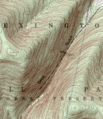
Topographic map of Deep Notch. It shows a steep cut in the land with a road at the bottom.

