Deer Lodge County, Montana facts for kids
Quick facts for kids
Deer Lodge County
|
||
|---|---|---|
|
Consolidated city-county
|
||

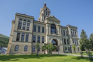
Deer Lodge County Courthouse
|
||
|
||

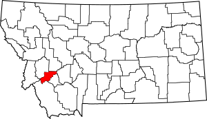
Location within the U.S. state of Montana
|
||
 Montana's location within the U.S. |
||
| Country | ||
| State | ||
| Founded | 1865 | |
| Seat | Anaconda | |
| Largest city | Anaconda | |
| Area | ||
| • Total | 741 sq mi (1,920 km2) | |
| • Land | 737 sq mi (1,910 km2) | |
| • Water | 4.7 sq mi (12 km2) 0.6% | |
| Population
(2020)
|
||
| • Total | 9,421 | |
| • Estimate
(2022)
|
9,510 |
|
| • Density | 12.714/sq mi (4.909/km2) | |
| Time zone | UTC−7 (Mountain) | |
| • Summer (DST) | UTC−6 (MDT) | |
| Congressional district | 1st | |
|
||
Deer Lodge County is a special kind of county in the state of Montana. It works like a single government with its main city, Anaconda. This means the city and county share one government.
In 2020, about 9,421 people lived here. The county was created way back in 1865. Since 1977, it has had this combined city-county government.
Contents
History of Deer Lodge County
Deer Lodge County was one of the first nine counties in Montana. It started when Montana became a territory in 1864.
Back then, the county was much bigger! It included areas that are now Silver Bow County, Granite County, and Powell County. These areas later became their own separate counties.
In 1976, people living in Deer Lodge County voted for a new way to run their government. They chose to combine the city and county governments. This new system started on January 1, 1977.
Geography of Deer Lodge County
Deer Lodge County covers about 741 square miles (1,920 km2) (square miles). Most of this is land, with a small part being water. It is the second-smallest county in Montana by land size.
The county has many beautiful natural places. These include the Anaconda Mountain Range and Georgetown Lake. It also has the Mount Haggin wildlife management area. This is Montana's largest wildlife area, covering 54,000 acres.
Main Roads in Deer Lodge County
 Interstate 90
 U.S. Highway 10 (This road used to be here)
 Montana Highway 1
 Montana Highway 43
 Montana Highway 48
Neighboring Counties
Deer Lodge County shares borders with these other counties:
- Granite County (to the northwest)
- Powell County (to the north)
- Jefferson County (to the east)
- Silver Bow County (to the southeast)
- Beaverhead County (to the south)
- Ravalli County (to the west)
Protected Natural Areas
Parts of two large national forests are found in Deer Lodge County:
- Beaverhead National Forest
- Deerlodge National Forest
Population of Deer Lodge County
| Historical population | |||
|---|---|---|---|
| Census | Pop. | %± | |
| 1870 | 4,367 | — | |
| 1880 | 8,876 | 103.3% | |
| 1890 | 15,155 | 70.7% | |
| 1900 | 17,393 | 14.8% | |
| 1910 | 12,988 | −25.3% | |
| 1920 | 15,323 | 18.0% | |
| 1930 | 16,293 | 6.3% | |
| 1940 | 13,627 | −16.4% | |
| 1950 | 16,553 | 21.5% | |
| 1960 | 18,640 | 12.6% | |
| 1970 | 15,652 | −16.0% | |
| 1980 | 12,518 | −20.0% | |
| 1990 | 10,278 | −17.9% | |
| 2000 | 9,417 | −8.4% | |
| 2010 | 9,298 | −1.3% | |
| 2020 | 9,421 | 1.3% | |
| 2022 (est.) | 9,510 | 2.3% | |
| U.S. Decennial Census 1790–1960, 1900–1990, 1990–2000, 2010–2020 |
|||
The number of people living in Deer Lodge County changes over time. In 2020, the census counted 9,421 people.
In 2010, there were 9,298 people. The average age of people living in the county was 46 years old.
Communities in Deer Lodge County
City
- Anaconda (This is the main city and county seat)
Small Towns and Areas
These are smaller communities that are not officially cities:
- Galen
- Georgetown
- Opportunity
- Warm Springs
It's important to remember that the town of Deer Lodge is actually in a different county, Powell County.
Famous People from Deer Lodge County
Many interesting people have connections to Deer Lodge County:
- Lucille Ball – A very famous actress and TV star, known for I Love Lucy
- John H. Collins – A smart person who studied old history
- Frank Cope – A football player for the New York Giants
- Marcus Daly – The person who started the city of Anaconda
- Wayne Estes – A college basketball star
- Raymond Hunthausen – A leader in the church (Archbishop of Seattle)
- Rob Johnson – A baseball player who played for the San Diego Padres
- Nancy Keenan – A politician and leader of an organization called NARAL
- George A. Lingo – A politician from the Alaska Territory
- Roger Rouse – A professional boxer
- George Leo Thomas – A leader in the Roman Catholic Church (Bishop of Helena)
- Lester Thurow – An expert in economics
- John H. Tolan – He later became a United States Congressman from California
See also
 In Spanish: Condado de Deer Lodge para niños
 | Leon Lynch |
 | Milton P. Webster |
 | Ferdinand Smith |


