Department of San Martín facts for kids
Quick facts for kids
Department of San Martín
|
|||
|---|---|---|---|

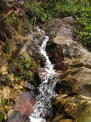
Upper Amazon waterfall
|
|||
|
|||

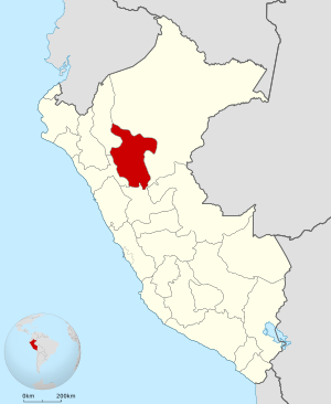
Location of the San Martín Region in Peru
|
|||
| Country | Peru | ||
| Subdivisions | 10 provinces and 78 districts | ||
| Largest city | Tarapoto | ||
| Capital | Moyobamba | ||
| Government | |||
| • Body | Regional Council of San Martín | ||
| Area | |||
| • Total | 51,253.31 km2 (19,789.01 sq mi) | ||
| Highest elevation | 3,080 m (10,100 ft) | ||
| Lowest elevation | 190 m (620 ft) | ||
| Population
(2017)
|
|||
| • Total | 813,381 | ||
| • Density | 15.869824/km2 (41.102655/sq mi) | ||
| UBIGEO |
22
|
||
| Dialing code | 042 | ||
| ISO 3166 code | PE-SAM | ||
| Principal resources | Coffee, rice, yucca, cocoa, tobacco, cebu cattle. | ||
| Poverty rate | 62.4% | ||
| Percentage of Peru's GDP | 1.85% | ||
| Website | www.regionsanmartin.gob.pe | ||
San Martín is a special area, or department, located in northern Peru. Most of this department is found in the upper part of the Peruvian Amazon rainforest. Its main city and capital is Moyobamba. The biggest city in the department is Tarapoto.
Contents
Where is San Martín?
San Martín is surrounded by other regions of Peru. Knowing its neighbors helps us understand its location.
Its Neighbors
- North and East: The Loreto Region
- South: The Huánuco Region
- West: The La Libertad and Amazonas regions
The Land and Rivers
The land in San Martín has four main types of areas. Each area looks different and has its own features.
The western part is close to the Andean Mountains. It has rough land with many deep valleys.
Next are wide valleys with flat steps. These were formed by the Huallaga River and its smaller rivers. People here mostly raise cattle and grow crops.
The southwest has hills coming down from the Cordillera Azul. These hills are not very high. Here you can find an amazing canyon called Cajón de Sión. It ends in the fast-moving Cayumba rapids.
Finally, there is a small area of lower jungle. This part can easily get flooded and has almost no hills.
The Huallaga River is very important for the region. It collects water from all over San Martín through its many branches. The Pongo de Aguirre is a famous canyon where the Huallaga River cuts through the Andean hills.
A Look Back in Time
Long ago, the Inca ruler Tupac Yupanqui entered and took control of the area. It was then known as Muyupampa, which is now Moyobamba.
In 1539, a Spanish explorer named Alonso de Alvarado reached the Mayo River. He founded a city he called Santiago de los Valles de Moyobamba. This city later became the capital of Maynas.
Another important person was Priest Manuel Sobreviela. Between 1787 and 1790, he traveled along the Huallaga River. He then made a map showing the paths of the Huallaga and Ucayali Rivers.
On August 19, 1821, Moyobamba was the first city in Peru to declare its independence. This was a very important moment for the country.
In recent years, a new highway was built. This road has made it easier to trade different products. This has helped the economy of San Martín grow and become stronger.
How San Martín is Organized
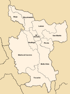
The San Martín region is divided into 10 main areas called provinces. Each province is then split into smaller parts called districts. There are 78 districts in total.
Here are the provinces and their capital cities:
- Bellavista (Bellavista)
- El Dorado (San José de Sisa)
- Huallaga (Saposoa)
- Lamas (Lamas)
- Mariscal Cáceres (Juanjuí)
- Moyobamba (Moyobamba)
- Picota (Picota)
- Rioja (Rioja)
- San Martín (Tarapoto)
- Tocache (Tocache)
Ancient Secrets
Gran Pajáten is an amazing ancient site. It was built by people who lived before the Inca Empire. It has circular buildings made of slate stone. These buildings are decorated with figures of flying condors.
This site is located near the border with the La Libertad Region. It is very hard to reach Gran Pajáten. Because of this, it is not yet open for many visitors or tourism.
Learn More
 In Spanish: Departamento de San Martín para niños
- Rio Abiseo National Park
- Regional Museum of the National University of San Martin (Museo Regional de la Universidad Nacional de San Martín)
 | Audre Lorde |
 | John Berry Meachum |
 | Ferdinand Lee Barnett |


