Dexter, Minnesota facts for kids
Quick facts for kids
Dexter, Minnesota
|
|
|---|---|
|
City
|
|

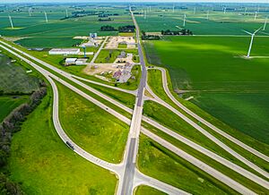
Located near the Pleasant Valley Wind Farm
|
|

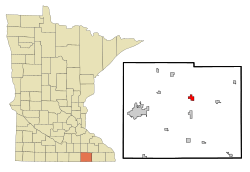
Location in Mower County and the state of Minnesota
|
|
| Country | United States |
| State | Minnesota |
| County | Mower |
| Area | |
| • Total | 1.41 sq mi (3.65 km2) |
| • Land | 1.41 sq mi (3.65 km2) |
| • Water | 0.00 sq mi (0.00 km2) |
| Elevation | 1,411 ft (430 m) |
| Population
(2020)
|
|
| • Total | 324 |
| • Density | 230.11/sq mi (88.83/km2) |
| Time zone | UTC-6 (Central (CST)) |
| • Summer (DST) | UTC-5 (CDT) |
| ZIP code |
55926
|
| Area code(s) | 507 |
| FIPS code | 27-15886 |
| GNIS feature ID | 2394528 |
Dexter is a small city in Mower County, Minnesota, United States. In 2020, about 324 people lived there. It is known for being near the Pleasant Valley Wind Farm.
Contents
History of Dexter
Dexter was officially started in 1874. It was named after Dexter Parrit, one of the first people to settle there. A post office opened in Dexter the same year. The city became an official town in 1878.
Where is Dexter Located?
Dexter is in the middle of Mower County. It is about 15 miles (24 km) east of Austin. Austin is the main city of Mower County. Dexter is also about 27 miles (43 km) southwest of Rochester.
The city is part of Dexter Township. It is just east of Grand Meadow Township. Major roads like Interstate 90 and State Highway 16 serve Dexter. Mower County Roads 2 and 7 also pass through the area.
Interstate 90 goes west to Austin. It also goes northeast about 16 miles (26 km) to Stewartville. State Highway 16 goes east about 16 miles (26 km) to Spring Valley.
According to the U.S. Census Bureau, Dexter covers about 1.41 square miles (3.65 square kilometers) of land. There is no water area in the city. Dexter is on high ground. Water from the city flows in different directions. Some water goes north to the North Branch of the Root River. Some goes east to Bear Creek, which is also part of the Root River. Other water flows southwest to Rose Creek, which is part of the Cedar River.
People of Dexter
| Historical population | |||
|---|---|---|---|
| Census | Pop. | %± | |
| 1880 | 168 | — | |
| 1890 | 150 | −10.7% | |
| 1900 | 278 | 85.3% | |
| 1910 | 281 | 1.1% | |
| 1920 | 298 | 6.0% | |
| 1930 | 242 | −18.8% | |
| 1940 | 303 | 25.2% | |
| 1950 | 316 | 4.3% | |
| 1960 | 313 | −0.9% | |
| 1970 | 252 | −19.5% | |
| 1980 | 279 | 10.7% | |
| 1990 | 303 | 8.6% | |
| 2000 | 333 | 9.9% | |
| 2010 | 341 | 2.4% | |
| 2020 | 324 | −5.0% | |
| U.S. Decennial Census | |||
The population of Dexter has changed over the years. In 1880, there were 168 people. The population grew to 341 people by 2010. By 2020, it was 324 people.
2010 Census Information
In 2010, there were 341 people living in Dexter. These people lived in 144 households. About 100 of these were families. The city had about 227 people per square mile (87.8 people per square kilometer).
Most people in Dexter were White (95.9%). A small number were African American, Native American, or Asian. Some people were of two or more races. About 1.8% of the population was Hispanic or Latino.
About 30% of households had children under 18 living with them. More than half (52.1%) were married couples. Some households had a single parent. About 26% of all households were individuals living alone. About 12.5% of these were people aged 65 or older. The average household had 2.37 people. The average family had 2.78 people.
The average age in Dexter was 41.2 years. About 21.4% of residents were under 18. About 15.8% were 65 or older. The city had almost an equal number of males (50.1%) and females (49.9%).
See also
 In Spanish: Dexter (Minnesota) para niños
 | Anna J. Cooper |
 | Mary McLeod Bethune |
 | Lillie Mae Bradford |


