
Dinas Powys facts for kids
Quick facts for kids Dinas Powys |
|
|---|---|
 A distant view of Dinas Powys |
|

Dinas Powys
|
|
| Population | 7,490 (2011) |
| OS grid reference | ST157711 |
| Principal area |
|
| Ceremonial county | |
| Country | Wales |
| Sovereign state | United Kingdom |
| Post town | Dinas Powys |
| Postcode district | CF64 |
| Dialling code | 029 |
| Police | South Wales |
| Fire | South Wales |
| Ambulance | Welsh |
| EU Parliament | Wales |
| UK Parliament |
|
| Welsh Assembly |
|
Dinas Powys (pronounced "Dinas Powis") is a town in South Wales, located in the Vale of Glamorgan. Its name means "fort of the provincial place." This name comes from an ancient Iron Age hillfort that stands above the town. Dinas Powys is about 5.6 miles (9 km) south-west of Cardiff. It's on the main road that connects Cardiff to Barry. Because of its location, many people who work in Cardiff choose to live here. It's also close to the bigger town of Penarth.
Even though many new houses have been built since the late 1900s, the older part of Dinas Powys still feels like a traditional, quiet village. It has a village common (a shared grassy area) and small local shops. You can also find pubs, restaurants, and places for community activities. Other parts of the town have garages, small supermarkets, a pharmacy, and a vet's office.
Around 8,800 people live in Dinas Powys. This makes it the fifth largest town in the Vale of Glamorgan.
Contents
- Discovering Dinas Powys: A Look at Its Past
- Geography: Where is Dinas Powys?
- How Dinas Powys is Governed
- Population of Dinas Powys
- Landmarks and Interesting Places
- Education in Dinas Powys
- Sports and Fun Activities
- Filming Locations
- Getting Around: Transport
- Famous People from Dinas Powys
- Images for kids
- See also
Discovering Dinas Powys: A Look at Its Past
Ancient Times and the Middle Ages
People have lived in the Dinas Powys area for a very long time. The oldest item found here is a Stone Age axe-head. It was discovered in 1949 and is now in the National Museum Cardiff. The Dinas Powys hillfort was once a very important and wealthy place. During the time of early Christianity, people in Dinas Powys even used everyday items that came from far-off places like Bordeaux, Athens, and Alexandria!

The village has parts of an old medieval castle. The nearby area called Cwm George was home to the Celtic hillfort that gave the village its name. Archaeologists studied the hillfort between 1953 and 1958. They found signs of large wooden buildings and many valuable metal items and jewelry. They also found glass items and pottery from other countries. These items date back to between the 5th and 7th centuries.
The castle was first owned by a Norman noble family called de Sumeri. But the castle started to fall apart around 1322 when the de Sumeri family line ended.
In the 11th century, Sir Reginald de Sully controlled Dinas Powys. He was one of the Twelve Knights of Glamorgan. A historical document from 1591 mentions that Sir Reginald was given the castle and town of Sully, along with the areas of St Andrews and Dinas Powys. He was a very wealthy and famous man.

Dinas Powys was part of an old Welsh area called the Cantref Brenhinol (the Royal Hundred). This area later became known as the Hundred of Dinas Powis. It included nearby places like St Andrews Major, Penarth, and Sully.
How Dinas Powys Grew in the 1800s
By 1833, Dinas Powys was a very small place. The nearby village of St. Andrews Major was much bigger, but together, their total population was only 474 people.
The village stayed small, with about 300-400 people, until the late 1800s. Then, many new people moved in, including a large group from the West Country. The coal industry was growing, and the first passenger train arrived in Dinas Powys on December 20, 1898. After this, the population quickly increased.
The new railway line was built at the bottom of the Dinas Powys valley. It offered a fast way to get to the new docks in Cardiff, Barry, and Penarth. These docks were built to handle the growing coal trade from the South Wales valleys. Before the railway, the area below St Andrews Major only had the small village of Dinas Powys, the Cadoxton Brook, and a few small farms.
.jpg)
The railway made it much easier to travel and transport goods. This made Dinas Powys a more appealing place to live, and many workers from Barry and Cardiff moved there. By 1891, the village population had more than doubled to 1,149 people. Ten years later, it was over 2,000. Dinas Powys grew in two main ways:
- Near the railway line, towards St. Andrew's Major, many large and fancy houses were built.
- Closer to the railway, in the area now known as Eastbrook, smaller, more modest houses were built for railway workers.
A few years after the railway, the main Cardiff Road was built. This road followed the path of an older, unpaved track. This led to even more people moving in and more houses being built.
Dinas Powys in the 1900s
A small part of the village common land was sold for £160 to the Barry Docks and Railway Company. Major General Henry Lee, who was the Lord of the Manor and a veteran of the First World War, added £30. In 1935, this money was used to improve the small green in the center of the village, known as the Twyn, and a war memorial was added there.
Geography: Where is Dinas Powys?

Dinas Powys stretches across a wooded valley, with the Cadoxton River flowing through it.
The soil around Dinas Powys is mostly strong, brown, and dry. This type of soil is good for growing crops. Because of this, the area was mainly a farming community until modern times. The ground underneath the whole area is made of limestone. This rock was likely formed under a warm ocean a very long time ago.

The village hasn't been able to expand much to the north. This is because of golf courses and protected woodlands between Dinas Powys and Michaelston-le-pit. These areas have stopped the two places from joining together. More recent housing has been built along the main Cardiff road and towards Cadoxton and Barry. Cwm George and Cwrt-yr-Ala are two important woodlands in the area.
Maps from the last hundred years show that Penarth and Dinas Powys have grown closer. In many spots, only a few hundred yards and a couple of fields separate them. However, there are no direct main roads connecting them. To drive between them, you have to go several miles through Llandough. The only direct road is the old, winding, single-lane Cross Common Road.
How Dinas Powys is Governed
The community of Dinas Powys (which includes St Andrews Major and Westra) chooses a community council. This council helps make decisions for the local area.
Dinas Powys is part of the Cardiff South and Penarth parliamentary area. This means it has a representative in the UK Parliament. Currently, the Labour MP Stephen Doughty represents this area.
For the Welsh Parliament (called the Senedd), Dinas Powys is part of the Vale of Glamorgan area. Jane Hutt of Welsh Labour represents this area in the Senedd.
Population of Dinas Powys
In 2001, the population of Dinas Powys was 8,512 people. By 2011, this number had gone down to 7,490. However, information from 2012 showed the population was around 8,790.
There aren't many big companies that employ a lot of people directly in the village. Most working people travel to Cardiff, Penarth, and Barry for their jobs.
Landmarks and Interesting Places
Some well-known places in Dinas Powys include Dinas Powys Castle, the village common, and the war memorial on the village green.
Garnhill House is a historic building with terraced gardens. It was even shown at the Royal Academy in 1904. The Green family has lived there for over 100 years.
The Mount is an old house from the Georgian period. It was originally a farmhouse called Mount Pleasant.
Churches and Religious Sites

St. Peter's Church on Mill Road is the main Church in Wales church in the village. Catholic people go to St. Mary's on Edith Road. St Peter's was built between 1929 and 1930. It replaced an older "Iron Church" that was too small. The new church was designed by J Coates Carter. Much of the stone used to build it came from the Cyfarthfa Ironworks, which had recently been taken down. St Peter's is now a historic building.
Dinas Powys is also known for its 14th-century Norman church, dedicated to St Andrew. This church is in the small village of St Andrews Major, less than a mile from the center of Dinas Powys. There's also the nearby church of St Michael and All Angels in Michaelston-le-Pit.
The village also has two Methodist chapels. One is a small "tin Tabernacle" in the Eastbrook area. The larger Methodist Church is near Station Road. Dinas Powys Baptist Church meets in the Parish Hall, and Bethesda Chapel is on Fairoaks. Ebenezer Presbyterian Church is in the Highwalls Road area.
Education in Dinas Powys

Dinas Powys has two primary schools:
- Dinas Powys Primary School (which was formed in 2015 by combining two older schools).
- St Andrews Major Church in Wales Primary School.
The village doesn't have its own secondary school. It used to be home to one part of Penarth’s St Cyres Comprehensive School. This site was for students aged 11 to 14. However, the Dinas Powys site closed in 2012. Now, all students go to a single, larger school in Penarth.
Sports and Fun Activities

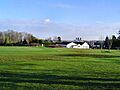
The village common is a great place for sports. It's managed by the Dinas Powys Community Council. Rugby has been played on the common since 1882! The Dinas Powys Rugby Club is located on the common. They play in the WRU League 1 East Central.
Organized sports are also played at Parc Bryn-a-don and the Murch Playing Fields.
Dinas Powys Football Club was the first football club in the Vale of Glamorgan to get the Football Association of Wales' Club Accreditation Scheme Bronze Award.
Dinas Powys Golf Club started in 1914. It offers amazing views over Cardiff and Cardiff Bay.
Dinas Powys Cricket Club was formed in 1882. The club has three teams that play in the Welsh Club Cricket Conference. Their home games are played at Parc Bryn y Don. They also have a junior section for younger players.
There has been an active Pony Club in the village since 1975. Dinas Powys also has many volunteer groups, including a large Scout group.
Filming Locations
The 2021 ITV television show Hollington Drive was filmed in Dinas Powys. It used a luxury housing estate on Ardwyn Walk as a filming location.
Also, in the popular TV series Gavin and Stacey, the house of Mick and Pam, which is supposed to be in Essex, is actually in Dinas Powys!
Getting Around: Transport

The village has two railway stations, one at each end:
- Eastbrook station is closer to Cardiff.
- Dinas Powys station is closer to Barry.
Both stations are on the Barry branch line. Passenger trains are run by Transport for Wales.
Famous People from Dinas Powys
Many interesting people live or have lived in Dinas Powys, including:
- John Smith – a former Member of Parliament.
- Ray Smith (1936–1991) – an actor.
- Huw Justin Smith (1965–2007) – also known as Pepsi Tate, he was the bass guitarist for the band Tigertailz. He was Ray Smith's son.
- Dave Edmunds (born 1944) – a recording artist and music producer.
- Donna Edwards – an actress.
- Noel Johnson – a radio actor.
- Jeremy Colman – a former Auditor General for Wales.
- Charlotte Church – a famous singer and TV personality.
Images for kids
-
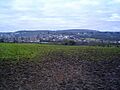
A distant view of Dinas Powys
-
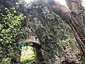
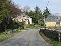
The entrance arch of Dinas Powys Castle, one of the only pieces of Norman architecture in the castle
-
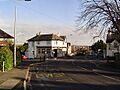
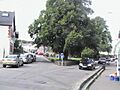
Downtown Dinas Powys
-
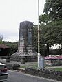
War memorial on the Twyn, Dinas Powys
-
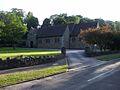
The Westra, Dinas Powys
-
Dinas Powys village centre
-
St Peter's Church, Dinas Powys
-
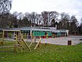
St Andrew's Major Primary School
-
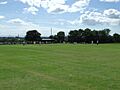
Cricket on the Common, Dinas Powys
-
Dinas Powys Golf Club
-
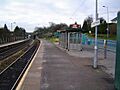
Dinas Powys railway station

See also
 In Spanish: Dinas Powys para niños
