Douglas Pass facts for kids
Quick facts for kids Douglas Pass |
|
|---|---|

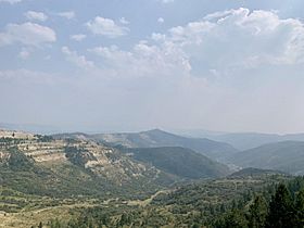
Douglas Pass in August 2020.
|
|
| Elevation | 8,205 ft (2,501 m) |
| Traversed by | State Highway 139 |
| Location | Garfield County, Colorado, United States |
| Range | Bookcliff Mountains |
| Coordinates | 39°35′51″N 108°48′11″W / 39.59750°N 108.80306°W |
| Topo map | USGS Douglas Pass |
Douglas Pass is a mountain pass in western Colorado, reaching an elevation of about 8,205 feet (2,501 meters). It is located in Garfield County and is crossed by Colorado State Highway 139. This pass is part of the Book Cliffs, which are large, flat-topped mountains.
Douglas Pass helps separate the areas where water flows. To the north, water flows into West Douglas Creek, and to the south, it flows into East Salt Creek. The pass is named after Chief Douglas, a leader of the Northern Ute tribe.
Exploring Douglas Pass
Douglas Pass is not one of the highest mountain passes in Colorado. The road that goes over it, State Highway 139, is quite steep on the south side (about 7% grade). However, it does not have many sharp turns or difficult spots, only a few switchbacks (zigzag turns).
From the top of the pass, you can see a unique view of the northeast side of the La Sal Mountains. These mountains are about 76 miles (122 km) away in Utah and have twelve peaks that are over 12,000 feet (3,658 meters) high. Most of the rest of the drive through the pass follows valleys and creeks.
How Was the Road Built?
The Ute people first created a trail over Douglas Pass many years ago. This trail was later used by early European explorers and settlers. For example, the Domínguez–Escalante expedition crossed this pass in 1776. Following the path of the old Ute trail, a modern road was built over the pass in the 1920s.
What is Douglas Pass Made Of?
The mountains around Douglas Pass are mostly made of a type of rock called shale. This shale comes from the Green River Formation, which is a very old rock layer. You can see these layers of shale exposed on the south side of the pass.
 | Leon Lynch |
 | Milton P. Webster |
 | Ferdinand Smith |

