Dover, Tennessee facts for kids
Quick facts for kids
Dover, Tennessee
|
|
|---|---|

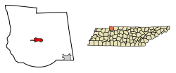
Location of Dover in Stewart County, Tennessee.
|
|
| Country | United States |
| State | Tennessee |
| County | Stewart |
| Area | |
| • Total | 3.96 sq mi (10.25 km2) |
| • Land | 3.85 sq mi (9.98 km2) |
| • Water | 0.10 sq mi (0.27 km2) |
| Elevation | 413 ft (126 m) |
| Population
(2020)
|
|
| • Total | 1,826 |
| • Density | 473.79/sq mi (182.91/km2) |
| Time zone | UTC-6 (Central (CST)) |
| • Summer (DST) | UTC-5 (CDT) |
| ZIP code |
37058
|
| Area code(s) | 931 |
| FIPS code | 47-21400 |
| GNIS feature ID | 1282753 |

Dover is a small city in Tennessee, USA. It is the main town, also known as the county seat, of Stewart County. Dover is located about 67 miles (108 km) west-northwest of Nashville. It sits right on the Cumberland River.
Dover is also home to the Fort Donelson National Cemetery. This is a special place where soldiers are buried. In 2020, about 1,826 people lived in Dover. The city is part of the larger Clarksville Metropolitan Area, which includes parts of Tennessee and Kentucky.
Contents
Geography
Dover is located at 36.482316 degrees North and 87.844678 degrees West.
The city covers a total area of about 3.9 square miles (10.1 square kilometers). Most of this area, about 3.8 square miles (9.8 square kilometers), is land. The rest, about 0.1 square miles (0.26 square kilometers), is water.
Climate in Dover
Dover has a climate with warm summers and mild winters. The hottest month is usually July, and the coldest is January. It gets a good amount of rain throughout the year.
| Climate data for Dover 1 W, Tennessee (1991–2020 normals, extremes 1897–present) | |||||||||||||
|---|---|---|---|---|---|---|---|---|---|---|---|---|---|
| Month | Jan | Feb | Mar | Apr | May | Jun | Jul | Aug | Sep | Oct | Nov | Dec | Year |
| Record high °F (°C) | 79 (26) |
84 (29) |
93 (34) |
97 (36) |
100 (38) |
114 (46) |
110 (43) |
107 (42) |
106 (41) |
96 (36) |
87 (31) |
79 (26) |
114 (46) |
| Mean daily maximum °F (°C) | 46.0 (7.8) |
50.8 (10.4) |
60.4 (15.8) |
70.3 (21.3) |
77.4 (25.2) |
84.4 (29.1) |
87.8 (31.0) |
87.7 (30.9) |
81.9 (27.7) |
70.8 (21.6) |
59.6 (15.3) |
49.7 (9.8) |
68.9 (20.5) |
| Daily mean °F (°C) | 36.7 (2.6) |
40.6 (4.8) |
49.4 (9.7) |
58.7 (14.8) |
67.2 (19.6) |
74.9 (23.8) |
78.4 (25.8) |
77.7 (25.4) |
70.9 (21.6) |
59.2 (15.1) |
48.9 (9.4) |
40.4 (4.7) |
58.6 (14.8) |
| Mean daily minimum °F (°C) | 27.4 (−2.6) |
30.4 (−0.9) |
38.4 (3.6) |
47.1 (8.4) |
56.9 (13.8) |
65.5 (18.6) |
69.0 (20.6) |
67.7 (19.8) |
59.9 (15.5) |
47.7 (8.7) |
38.1 (3.4) |
31.2 (−0.4) |
48.3 (9.1) |
| Record low °F (°C) | −24 (−31) |
−21 (−29) |
−3 (−19) |
21 (−6) |
30 (−1) |
38 (3) |
44 (7) |
44 (7) |
24 (−4) |
19 (−7) |
−7 (−22) |
−18 (−28) |
−24 (−31) |
| Average precipitation inches (mm) | 4.19 (106) |
4.82 (122) |
5.24 (133) |
5.66 (144) |
6.03 (153) |
4.53 (115) |
4.32 (110) |
3.77 (96) |
3.56 (90) |
3.82 (97) |
4.26 (108) |
4.60 (117) |
54.80 (1,392) |
| Average snowfall inches (cm) | 1.3 (3.3) |
1.3 (3.3) |
0.4 (1.0) |
0.0 (0.0) |
0.0 (0.0) |
0.0 (0.0) |
0.0 (0.0) |
0.0 (0.0) |
0.0 (0.0) |
0.0 (0.0) |
0.1 (0.25) |
0.7 (1.8) |
3.8 (9.7) |
| Average precipitation days (≥ 0.01 in) | 8.8 | 8.4 | 9.5 | 9.8 | 10.0 | 8.1 | 7.7 | 6.8 | 7.0 | 7.3 | 8.1 | 8.7 | 100.2 |
| Average snowy days (≥ 0.1 in) | 1.0 | 0.9 | 0.2 | 0.0 | 0.0 | 0.0 | 0.0 | 0.0 | 0.0 | 0.0 | 0.0 | 0.2 | 2.3 |
| Source: NOAA | |||||||||||||
People of Dover
| Historical population | |||
|---|---|---|---|
| Census | Pop. | %± | |
| 1860 | 298 | — | |
| 1870 | 270 | −9.4% | |
| 1880 | 317 | 17.4% | |
| 1900 | 400 | — | |
| 1960 | 736 | — | |
| 1970 | 1,179 | 60.2% | |
| 1980 | 1,197 | 1.5% | |
| 1990 | 1,341 | 12.0% | |
| 2000 | 1,442 | 7.5% | |
| 2010 | 1,417 | −1.7% | |
| 2020 | 1,826 | 28.9% | |
| Sources: | |||
The number of people living in Dover has changed over the years. In 1860, there were 298 residents. By 2020, the population had grown to 1,826 people.
Who Lives in Dover?
The 2020 United States census showed that 1,826 people lived in Dover. There were 697 households and 381 families in the city.
Here is a look at the different groups of people living in Dover:
| Race | Number | Percentage |
|---|---|---|
| White (non-Hispanic) | 1,648 | 90.25% |
| Black or African American (non-Hispanic) | 57 | 3.12% |
| Native American | 4 | 0.22% |
| Asian | 9 | 0.49% |
| Other/Mixed | 51 | 2.79% |
| Hispanic or Latino | 57 | 3.12% |
Fun Things to See and Do
Dover has some interesting places to visit, especially if you like history and nature!
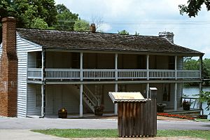
- Fort Donelson: This historic site is west of downtown Dover. It was a very important place during the American Civil War. A big victory for the Union happened here. Today, it's part of the Fort Donelson National Battlefield Park.
- Cross Creeks National Wildlife Refuge: East of Dover, this huge area is about 8,862 acres (35.86 square kilometers). It's a special home for many waterfowl (like ducks and geese) and water plants. It's located on the Cumberland River.
- Land Between the Lakes National Recreation Area: This large outdoor area is only about 6 miles (9.7 km) from downtown Dover. It's a great place for camping, hiking, and enjoying nature.
Did you know that famous American singer-songwriter Dolly Parton was inspired by Dover? She wrote her song "Down from Dover" after riding through the town on a tour bus!
Local Media
Dover has a few local radio stations that play music and news:
- WTPR-FM 101.7: Plays "The Greatest Hits of All Time."
- WTPR-AM 710: Also plays "The Greatest Hits of All Time."
- WRQR-FM 105.5: Plays "Today's Best Music" and features the Ace & TJ in the morning.
Famous People from Dover
Some notable people have connections to Dover:
- Isham N. Haynie: A lawyer, politician, and soldier who served as an officer in the Union Army.
- William B. Ross: He became the 12th Governor of Wyoming.
- Bernie Walter: A professional baseball player.
See also
 In Spanish: Dover (Tennessee) para niños
 | Madam C. J. Walker |
 | Janet Emerson Bashen |
 | Annie Turnbo Malone |
 | Maggie L. Walker |

