Dox Castle facts for kids
Quick facts for kids Dox Castle |
|
|---|---|

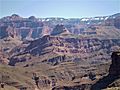
Southwest aspect at sunrise
|
|
| Highest point | |
| Elevation | 4,780 ft (1,460 m) |
| Prominence | 760 ft (230 m) |
| Isolation | 2.05 mi (3.30 km) |
| Parent peak | Evans Butte (6,379 ft) |
| Naming | |
| Etymology | Virginia Dox |
| Geography | |

Dox Castle
Location in Arizona

Dox Castle
Location in the United States
|
|
| Location | Grand Canyon National Park Coconino County, Arizona, US |
| Parent range | Kaibab Plateau Colorado Plateau |
| Topo map | USGS Havasupai Point |
| Type of rock | sandstone, siltstone, limestone |
| Climbing | |
| Easiest route | class 5.3 climbing |
Dox Castle is a tall rock formation, or "summit," located in the amazing Grand Canyon in Arizona, USA. It stands 4,780 feet (about 1,460 meters) above sea level. This impressive natural landmark is found in Coconino County, in the northern part of Arizona.
Dox Castle is a huge structure. It rises about 2,500 feet (760 meters) above the famous Colorado River that flows through the Grand Canyon. It's located near other interesting places like Havasupai Point, Evans Butte, and Holy Grail Temple.
How Dox Castle Got Its Name
Dox Castle was named by two people: William Wallace Bass and George Wharton James. They named it after Virginia Dox (1851–1941). She was a remarkable woman who, in 1891, became the first white woman to explore this specific part of the Grand Canyon.
Virginia Dox was very impressed by her guide, William Bass. She actually named another nearby rock formation Bass Tomb (which is now called Holy Grail Temple) in his honor. William Bass, in turn, was so impressed by Virginia Dox that he named Dox Castle shortly after her visit. The name "Dox Castle" was officially recognized in 1908 by the U.S. Board on Geographic Names.
What Dox Castle is Made Of
Dox Castle is made up of different types of rock that have formed over millions of years. The upper parts of the castle are made from rocks that formed during the Cambrian period. These rocks are part of what geologists call the Tonto Group.
Below these layers, closer to the river, you can find even older rocks. These are from the Proterozoic era and are part of the Unkar Group. A scientist named Levi F. Noble studied these rocks. He even named a specific rock layer, the Dox Formation, because he found good examples of it near Dox Castle in a small stream that flows into Shinumo Creek.
The area around Dox Castle has a "cold semi-arid climate." This means it's generally dry, but it can get cold, especially in winter. Any rain that falls in this area usually flows into Shinumo Creek, which then carries the water west towards the Colorado River.
Gallery
-
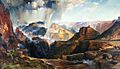
Dox Castle is centered in bullseye of this famous painting by Thomas Moran.
"Chasm of the Colorado" (1873–74), a large canvas measuring 7 feet high by 12 feet wide, hung prominently in the US Capitol for over a half-century. -
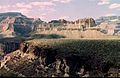
Holy Grail Temple centered with Dox Castle below to right, from southwest
-
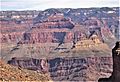
Dox Castle centered, King Arthur Castle upper left. From the west.
-
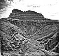
North aspect, 1901
-
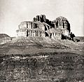
Dox Castle circa 1901
-