
Holy Grail Temple facts for kids
Quick facts for kids Holy Grail Temple |
|
|---|---|

Southwest aspect, with Dox Castle, seen from South Bass Trail
|
|
| Highest point | |
| Elevation | 6,711 ft (2,046 m) |
| Prominence | 1,199 ft (365 m) |
| Isolation | 2.0 mi (3.2 km) |
| Parent peak | King Arthur Castle (7,344 ft) |
| Geography | |

Holy Grail Temple
Location in Arizona

Holy Grail Temple
Location in the United States
|
|
| Location | Grand Canyon National Park Coconino County, Arizona, US |
| Parent range | Kaibab Plateau Colorado Plateau |
| Topo map | USGS King Arthur Castle |
| Type of rock | sandstone, siltstone, mudstone |
| Climbing | |
| First ascent | 1977 |
| Easiest route | class 5.8 climbing |
Holy Grail Temple is a tall mountain peak in the Grand Canyon, Arizona, USA. It stands 6,711 feet (2,046 meters) high. You can find it about seven miles northeast of Havasupai Point. It's also two miles northwest of King Arthur Castle. This mountain rises very steeply. It soars over 4,500 feet (1,370 meters) above the Colorado River in just three miles! The area has a cold, dry climate. Rainwater flows down to Shinumo Creek. This creek then carries the water to the Colorado River.
Contents
Mountain's Story: How It Got Its Name
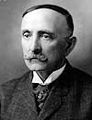
Holy Grail Temple got its first name, "Bass Tomb," in 1891. A woman named Virginia Dox gave it this name. She named it after her guide, William Wallace Bass. William Bass was so impressed by Virginia Dox. He named a nearby peak, Dox Castle, after her.
Later, the U.S. Geological Survey suggested a new name. They wanted to name it "Holy Grail Temple." This name comes from the Holy Grail in the Legend of King Arthur. Many other places nearby also have names from the King Arthur stories. These include King Arthur Castle, Guinevere Castle, Elaine Castle, Excalibur, Gawain Abyss, Bedivere Point, Lancelot Point, and Galahad Point. The U.S. Board on Geographic Names officially adopted the name "Holy Grail Temple" in 1908.

William Bass's Legacy
William W. Bass passed away in 1933. His ashes were scattered by plane on top of this mountain. This was his last wish. Bass Canyon and the Bass Trails in the Grand Canyon are still named after him.
The first people to successfully climb to the top of Holy Grail Temple were Larry Treiber and Bruce Grubbs. They made the difficult climb in 1977.
What the Mountain Is Made Of
The very top of Holy Grail Temple is made of cream-colored Permian Coconino Sandstone. This sandstone is a type of rock formed from sand. It was created 265 million years ago from sand dunes.
Below the Coconino Sandstone, you'll find the Permian Hermit Formation. This rock layer sits on top of the Pennsylvanian-Permian Supai Group. Even further down are layers of Mississippian Redwall Limestone. Then comes the Cambrian Tonto Group. Finally, at the bottom, near the creek, is the Proterozoic Unkar Group.
The actual small peak at the top has a cap of Coconino Sandstone. This cap sits on a small slope of Hermit Formation. This peak rests on a large flat area made of the Supai Group. This part of the Supai Group is called the Esplanade Sandstone. It is very strong and thick in the western Grand Canyon.

Images for kids
-
W. W. Bass

