
Eagle Point (Olympic Mountains) facts for kids
Quick facts for kids Eagle Point |
|
|---|---|

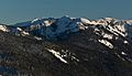
Eagle Point seen from the south
|
|
| Highest point | |
| Elevation | 6,247 ft (1,904 m) |
| Prominence | 161 ft (49 m) |
| Geography | |

Eagle Point
Location in Washington (state)

Eagle Point
Location in the United States
|
|
| Location | Clallam County, Washington, US |
| Parent range | Olympic Mountains |
| Topo map | USGS Mount Angeles |
| Geology | |
| Age of rock | Eocene |
| Climbing | |
| Easiest route | Hiking class 2 |
Eagle Point is a mountain peak in the beautiful Olympic Mountains of Washington state. It stands tall at 6,247 feet (about 1,904 meters) above sea level. You can find it in Clallam County, inside the amazing Olympic National Park.
This peak is located on Hurricane Ridge. It sits between Steeple Rock and Obstruction Peak. Obstruction Peak is the closest higher mountain, about 1.42 miles (2.29 km) to the southeast. Water from Eagle Point flows into streams that feed the Elwha River and Morse Creek. These waters then reach the Strait of Juan de Fuca.
Climate and Weather
Eagle Point is in the northern part of the Olympic Mountains. It has a marine west coast climate. This means it gets a lot of moisture from the Pacific Ocean. Most weather fronts come from the Pacific and move towards the Olympic Mountains.
When these weather fronts hit the tall mountains, they are forced to rise. As the air goes higher, it cools down and drops its moisture. This creates a lot of rain or snow, a process called Orographic lift. Because of this, the Olympic Mountains get a lot of precipitation, especially heavy snowfall in winter.
During winter, the weather is often cloudy. However, in summer, high-pressure systems over the Pacific Ocean bring clear skies. This means there is often little or no cloud cover. The ocean's influence makes the snow wet and heavy. This can lead to a high risk of avalanches.
- Weather forecast: Eagle Point

Images for kids
-
West side of Eagle Point in winter, seen from the Hurricane Ridge Visitor Center area.

