
Obstruction Peak facts for kids
Quick facts for kids Obstruction Peak |
|
|---|---|

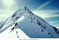
Obstruction Peak seen from the west
|
|
| Highest point | |
| Elevation | 6,450 ft (1,970 m) |
| Prominence | 250 ft (76 m) |
| Isolation | 1.39 mi (2.24 km) |
| Parent peak | Elk Mountain (6,773 ft) |
| Geography | |

Obstruction Peak
Location in Washington (state)

Obstruction Peak
Location in the United States
|
|
| Location | Olympic National Park Clallam County, Washington, US |
| Parent range | Olympic Mountains |
| Topo map | USGS Mount Angeles |
| Geology | |
| Age of rock | Eocene |
| Type of rock | Shale |
| Climbing | |
| Easiest route | Hiking class 2 |
Obstruction Peak is a tall mountain, standing about 6,450 feet (1,970 m) high. It's part of the amazing Olympic Mountains in Washington state, specifically in Clallam County. You'll find it inside Olympic National Park. It's at the very end of Obstruction Point Road. This road is a narrow, eight-mile dirt path located on Hurricane Ridge.
The road stops near the mountain's southern side. From there, it's just a short hike to reach the top! The closest mountain that's even taller is Elk Mountain. It's about 0.46 mi (0.74 km) to the northeast. Obstruction Peak is a special spot because it's a "triple divide point." This means that rain and snow falling on its slopes flow into three different river systems. These are the Elwha River, Dungeness River, and Morse Creek. All three rivers eventually empty into the Strait of Juan de Fuca.
Contents
Understanding the Climate at Obstruction Peak
Obstruction Peak is located in the northern part of the Olympic Mountains. This area has a "marine west coast" climate. This type of climate is found near oceans. Most of the weather systems here start over the Pacific Ocean. They then travel northeast towards the Olympic Mountains.
How Mountains Affect Weather
When these weather systems reach the tall Olympic peaks, they are forced to rise. As the air goes higher, it cools down. This cooling makes the moisture in the air turn into rain or snow. This process is called Orographic lift. Because of this, the Olympic Mountains get a lot of rain and snow. This is especially true during the winter months.
Winter Conditions and Safety
The snow in this area tends to be wet and heavy. This is because of the ocean's influence. Heavy snow can lead to a high risk of avalanches. During winter, the weather is often cloudy. However, in summer, high pressure systems over the Pacific Ocean bring clear skies. This means there's often little or no cloud cover. The best time to visit or hike Obstruction Peak is usually from July through September. The weather is most pleasant then.
The Story Behind the Name: Obstruction Peak
The name "Obstruction Peak" has an interesting history. It's linked to a road-building project from the 1940s.
Why the Road Stopped Here
Plans were made to build a road that would loop all the way around. It was supposed to go from the Elwha River to Hurricane Ridge and Deer Park. Then it would continue on to Port Angeles. However, the project had to stop right at Obstruction Point. The ground here was made of loose shale rock. This made the slopes very unstable. Because the project was "obstructed" or stopped, the peak got its name.
- Weather forecast: Obstruction Peak
Images for kids
-
Northeast aspect

