Early Indian treaty territories in North Dakota facts for kids
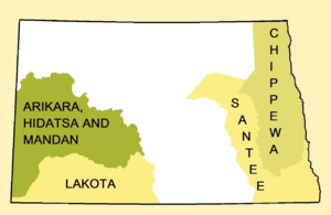
Long ago, many different Native American tribes lived in what is now North Dakota. As more settlers arrived, the tribes and the newcomers signed many treaties. These treaties were like official agreements. They often decided which land belonged to a specific Native American group.
This article will show you how these land areas changed. We will look at how the territories of different tribes in North Dakota grew smaller during the 1800s. When we say "North Dakota," we mean the area that is North Dakota today.
Contents
Understanding Early Land Agreements (1851-1891)
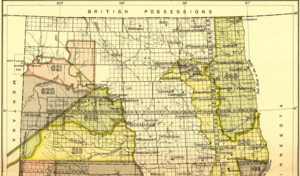
This map shows some of the first treaty areas. Let's explore how these lands were used and changed.
The Chippewa's Land (Area 445)
Area 445 was the home of the Red Lake and Pembina bands of the Chippewa tribe. This land also stretched into Minnesota. In 1863, the Chippewa gave up all their land in North Dakota. They then moved to land they still owned in Minnesota.
Sisseton and Wahpeton Sioux Lands (Areas 496, 497, 538)
The Sisseton and Wahpeton bands of the Santee Sioux claimed these areas. Area 538 went far into South Dakota. In 1867, they allowed roads and railroads to be built through their land. They did not give up any land at this time.
Two special areas, called reservations, were set up for them. Area 496 was the Sisseton reservation near Lake Traverse. A northern reservation (Area 497) was next to Devil's Lake.
In 1872, the Sioux gave up the yellow Area 538. This agreement was officially approved in 1874. Later, in 1891, all the unused land in the Lake Traverse Indian Reservation (Area 496) was given to the United States.
Lakota Sioux Territory (Area 516)
Area 516 was west of the Missouri River and south of the Heart River. This land was part of a larger Lakota territory. This was set up by the Treaty of Fort Laramie (1851).
To end a conflict called Red Cloud's War, a new Fort Laramie treaty was signed in 1868. The Lakotas gave Area 516 in North Dakota to the United States. They also agreed to live in The Great Sioux Reservation. This large reservation was mostly in South Dakota.
Changes to Native American Lands (1875-1889)
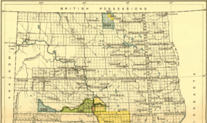
This map shows how land agreements continued to change.
Sioux Land Adjustments (Areas 581, 599, 653)
In 1875, some land that was given up in 1868 was returned to the Sioux tribe. This included the green Area 581. They also received extra land east of the Missouri River. This new land was next to an existing Yankton Sioux Reservation in South Dakota.
Later, in 1879, some of this new eastern land was given back to the government.
After the Battle of the Little Bighorn, the Sioux gave up about a quarter of their Great Sioux Reservation in South Dakota. This agreement in 1876 added a new section to the Sioux land in North Dakota (blue Area 599). It connected to Area 581.
In late 1876, more land was added to the Sioux territory east of the Missouri River. However, this same area was returned to public land in 1879. A small piece of land near the Missouri River also went back to the United States in 1884 (light scarlet Area 653).
Finally, Area 599, which was added in 1876, was taken away again in 1889.
Arikara, Hidatsa, and Mandan Lands (Areas 529, 620, 621)
These three areas together show the shared land of the Arikara, Hidatsa, and Mandan tribes. This was set up by the Treaty of Fort Laramie in 1851. Their land also reached into Montana and Wyoming.
In 1870, Area 529 became U.S. territory. At the same time, the Fort Berthold Reservation was created. The United States also recognized a narrow strip of land north of the Missouri River as Arikara, Hidatsa, and Mandan territory. This was very important because their main village, Like-a-Fishhook Village, was located there.
In 1880, Area 620 was taken from the tribes' land.
More Changes to Fort Berthold and Chippewa Lands
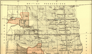
This map shows the final changes to some of these areas.
Fort Berthold Reservation (Areas 712, 713, 716)
Even though some land was lost, extra land north of the Missouri River made up for it. Areas 712 and 713 together show the full size of the Fort Berthold Reservation in 1880.
Area 712 was given to the United States in 1886. This agreement was approved in 1891. Area 713 shows the smaller amount of land that the Arikara, Hidatsa, and Mandan tribes kept.
The reservation grew a little bit in 1892. A small piece of land was added to its east side (Area 716).
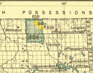
Turtle Mountain Chippewa Reserve (Areas 654, 656)
These areas together show a special reserve for the Chippewa tribe. This was for the Turtle Mountain band. It was created in 1882.
Two years later, in 1884, most of this land was given up. The smaller reserve for the Turtle Mountain Chippewa is shown as two yellow areas.
Within three months, the reserve was changed again to make it a single, connected area. This made it much easier for the tribe to use their land.
 | Shirley Ann Jackson |
 | Garett Morgan |
 | J. Ernest Wilkins Jr. |
 | Elijah McCoy |


