East Fork Carson River facts for kids
Quick facts for kids East Fork Carson River |
|
|---|---|

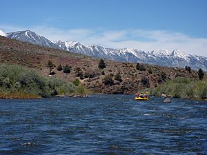
Rafting the East Fork of the Carson River
|
|

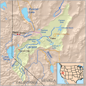
Map of the Carson River watershed
|
|
| Country | United States |
| State | California, Nevada |
| Physical characteristics | |
| Main source | Sierra Nevada Alpine County, California 10,312 ft (3,143 m) 38°21′41″N 119°37′36″W / 38.36139°N 119.62667°W |
| River mouth | Carson River Douglas County, Nevada 4,675 ft (1,425 m) 38°59′27″N 119°49′29″W / 38.99083°N 119.82472°W |
| Length | 61 mi (98 km) |
| Basin features | |
| Basin size | 392 sq mi (1,020 km2) |
The East Fork Carson River is a major river in the western United States. It flows through parts of California and Nevada. This river is the biggest branch of the main Carson River. It flows north for about 61 miles (98 km). The river collects water from a large area of mountains and countryside, covering about 392 square miles (1,015 km²).
Contents
River's Journey
The East Fork Carson River starts high up in the mountains. Its source is at Sonora Peak in the Sierra Nevada mountain range. This area is in Alpine County, California. The very beginning of the river is found within the Carson-Iceberg Wilderness. This wilderness area is part of the Humboldt-Toiyabe National Forest.
Flowing North
The river flows north through a special U-shaped valley. This valley was carved out by ancient glaciers. Along its path, the river drops over a waterfall called Carson Falls. It then continues into the Silver King Valley. Here, it meets Silver King Creek. After this, the river turns northwest. It flows to a place called Centerville Flat. There, it is joined by another stream, Silver Creek, and turns north again.
Along the Highway
Between Centerville Flat and Markleeville, California, the river flows through a canyon. Parts of two state highways, SR 4 and SR 89, follow this canyon. These roads are also known as the Alpine State Highway. At Markleeville, the river gets more water from a big stream called Markleeville Creek.
Into Nevada
After Markleeville, the river continues its journey north. It crosses into Douglas County, Nevada. In Nevada, the river enters a farming area called the Carson Valley. It flows through the Washoe Indian Reservation. The river passes by towns like Dresslerville, Gardnerville, and Minden.
Joining the Carson River
Finally, the East Fork Carson River meets the West Fork Carson River. This meeting point is on the western edge of the valley, near Genoa. When these two forks join, they form the main Carson River. The Carson River then flows for another 131 miles (211 km). It eventually ends in a dry lakebed called the Carson Sink in Churchill County, Nevada.
Past Plans for the River
In 1962, a government agency called the United States Bureau of Reclamation (USBR) had an idea. They wanted to build a dam on the East Fork Carson River. This dam would have helped provide water for farming. It would also have generated electricity. The project was estimated to cost about $23 million. The water from this proposed dam would have stretched about nine miles into California. However, this dam was never built.
 | Calvin Brent |
 | Walter T. Bailey |
 | Martha Cassell Thompson |
 | Alberta Jeannette Cassell |

