East Kennebago Mountain facts for kids
Quick facts for kids East Kennebago Mountain |
|
|---|---|

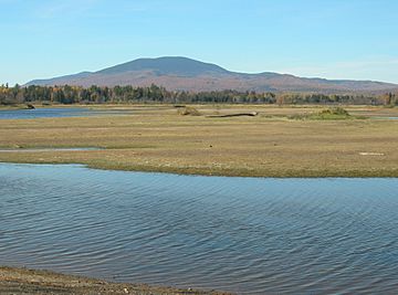
East Kennebago Mt. seen from near Stratton
|
|
| Highest point | |
| Elevation | 3,789 ft (1,155 m) |
| Prominence | 1,804 ft (550 m) |
| Listing | New England 100 Highest #91 |
| Geography | |
| Topo map | USGS Quill Hill |
| Climbing | |
| Easiest route | logging roads, then bushwhack |
East Kennebago Mountain is a cool mountain located in Franklin County, Maine. It's a special kind of mountain called a monadnock, which means it stands all by itself, rising high above the flat land around it. You won't find any marked trails here, making it a true wilderness adventure! This mountain has smaller "spurs" or ridges nearby, like Tim Mountain to the north and Blackcat Mountain to the southwest.
Contents
Exploring East Kennebago Mountain
East Kennebago Mountain is a great spot for adventurers who love the outdoors. It's known as a "trailless" mountain. This means there are no official hiking paths to the top. People who want to reach the summit often follow old logging roads part of the way. After that, they have to make their own way through the trees and bushes. This is called "bushwhacking." It's a challenging but rewarding way to experience nature.
What is a Monadnock?
A monadnock is a special type of mountain. Imagine a big, lonely hill or mountain that sticks up from a mostly flat area. That's a monadnock! East Kennebago Mountain is a perfect example. It stands out because the land around it has worn away over millions of years, but the mountain itself is made of tougher rock that resisted erosion.
Nearby Peaks and Ridges
East Kennebago Mountain isn't completely alone. It has smaller ridges or "spurs" that extend from its main body. These include:
- Tim Mountain to the north
- Black Spur to the west
- Blackcat Mountain to the southwest
These smaller peaks add to the rugged beauty of the area.
Water Flowing from the Mountain
Water from East Kennebago Mountain flows in different directions, eventually reaching the ocean. It's like a giant natural plumbing system!
Journey to the Kennebec River
The water from the southeast side of East Kennebago Mountain flows into the South Branch of the Dead River. This water then travels into Flagstaff Lake. From there, it continues its journey down the Dead River and into the mighty Kennebec River. Finally, the Kennebec River carries the water all the way to the Gulf of Maine, which is part of the Atlantic Ocean.
Path to the Androscoggin River
On the southwest side, water from East Kennebago Mountain flows into Kennebago Lake. From Kennebago Lake, the water enters the Kennebago River. It then passes through several other lakes, including Cupsuptic Lake. Eventually, this water reaches the Rapid River and then Umbagog Lake. Umbagog Lake is the starting point for the Androscoggin River. This river also makes its way to the ocean, joining the Kennebec River's estuary at Merrymeeting Bay.
Other Waterways
- Water from the northeast part of the mountain flows into Cherry Run, which also joins the South Branch of the Dead River.
- On the northwest side, Big Sag Brook carries water into Kennebago Lake.
It's amazing how all these small streams and brooks connect to form larger rivers that eventually reach the sea!
 | Laphonza Butler |
 | Daisy Bates |
 | Elizabeth Piper Ensley |


