Eaton Peak facts for kids
Quick facts for kids Eaton Peak |
|
|---|---|

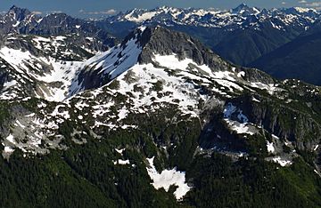
North aspect of Eaton Peak seen from Mt. Grant
|
|
| Highest point | |
| Elevation | 2,117 m (6,946 ft) |
| Prominence | 387 m (1,270 ft) |
| Parent peak | Silvertip Mountain |
| Geography | |
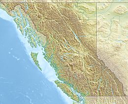
| Location | British Columbia, Canada |
| Parent range | Skagit Range Canadian Cascades |
| Topo map | NTS 92 H/3 |
| Geology | |
| Mountain type | Intrusive |
| Climbing | |
| First ascent | 1950 J. Butcher, F. Rodgers, E. Jenkins |
| Easiest route | Scrambling via West Ridge |
Eaton Peak is a tall mountain in southwestern British Columbia, Canada. It stands about 2,117-metre (6,946-foot) high. This mountain has two main tops, making it a "double summit." It's part of the Canadian Cascades mountain range. Eaton Peak is located about 17 km (11 mi) southeast of Hope. It is also 3 km (2 mi) south of Mt. Grant and 12.6 km (8 mi) northwest of Silvertip Mountain.
The first people to climb this peak were J. Butcher, F. Rodgers, and E. Jenkins in 1950. The mountain is named after Douglas B. Eaton, a Canadian Army Private from Chilliwack. He bravely served in World War II and was killed in action in 1944. The name "Eaton Peak" became official in 1955. Nearby Eaton Creek and Eaton Lake are named for his younger brother, William, who also died in the war a year earlier. Water from the peak flows into Silverhope Creek, which then joins the Fraser River.
Contents
How Eaton Peak Was Formed
Ancient Rocks and Volcanoes
Eaton Peak is made of rock that came from deep inside the Earth. This rock is part of the Chilliwack batholith. It formed about 26 to 29 million years ago. This happened after big mountain-building events in the area.
The mountain is also linked to the Pemberton Volcanic Belt. This was once a chain of volcanoes. It formed when one of Earth's plates, the Farallon Plate, slid under another plate. This process, called subduction, started about 29 million years ago. Over time, these volcanoes wore down.
Glaciers and Valleys
For over two million years, during the Pleistocene period, huge sheets of ice called glaciers covered this area. These glaciers moved across the land many times. As they moved, they scraped away rock and left behind rocky debris.
The "U"-shaped valleys you see in the area were carved out by these glaciers. The combination of land being pushed up (called uplift) and cracks in the Earth's crust (called faulting) worked with the glaciers. Together, these forces created the tall peaks and deep valleys of the North Cascades.
The North Cascades has very rugged land. You can see jagged peaks, sharp ridges, and deep glacial valleys. There are also tall, pointed rocks made of granite. All these different landforms were created by geological events long ago. These changes also led to different climates and types of plants in the area.
Weather at Eaton Peak
Understanding the Climate
Most of the weather that affects Eaton Peak comes from the Pacific Ocean. These weather systems travel east towards the Cascade Range. When they hit the mountains, the air is forced to rise. This process is called Orographic lift. As the air rises, it cools and drops its moisture. This means the Cascade Mountains get a lot of rain or snow.
Temperatures and Best Time to Visit
The mountains get especially heavy snowfall during the winter months. Temperatures can drop very low, sometimes below −20 °C. With the wind, it can feel even colder, below −30 °C.
If you want to climb Eaton Peak, the best time to go is usually from July through September. These months offer the most pleasant weather for mountain activities.
Climbing Routes
If you are an experienced climber, here are some known routes on Eaton Peak:
- West Ridge - class 3
- Southeast Ridge
- North Ridge
 | Tommie Smith |
 | Simone Manuel |
 | Shani Davis |
 | Simone Biles |
 | Alice Coachman |


