Mount Grant (British Columbia) facts for kids
Quick facts for kids Mount Grant |
|
|---|---|

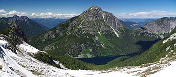
South aspect of Mount Grant above Eaton Lake as seen from slopes of Eaton Peak
|
|
| Highest point | |
| Elevation | 2,180 m (7,150 ft) |
| Prominence | 590 m (1,940 ft) |
| Parent peak | Silvertip Mountain |
| Geography | |
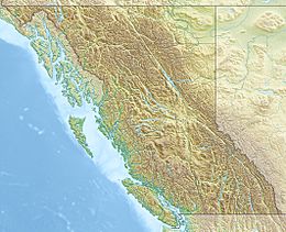
| Location | British Columbia, Canada |
| Parent range | Skagit Range Canadian Cascades |
| Topo map | NTS 92 H/6 |
| Geology | |
| Mountain type | Intrusive |
| Type of rock | granitic |
| Climbing | |
| First ascent | 1951 |
| Easiest route | Scrambling |
Mount Grant is a tall mountain in southwestern British Columbia, Canada. It stands about 2,180 meters (7,150 feet) high. This mountain is part of the Canadian Cascades mountain range. You can find it about 12 kilometers (7.5 miles) southeast of Hope. It is also about 15 kilometers (9 miles) northwest of Silvertip Mountain.
The first people to climb Mount Grant reached its top on June 15, 1951. A group of six climbers, including Paul Binkert and Jim Teevan, made this first ascent. The mountain was named after Captain John M. Grant of the Royal Engineers. This name was given by a famous climber and author, Fred Beckey. Water from Mount Grant flows into streams that eventually join the Fraser River.
How Mount Grant Formed: Geology Basics
Mount Grant is made of granitic rock. This rock formed deep underground from melted rock (magma). It is part of a large body of rock called the Chilliwack batholith. This batholith pushed into the area about 26 to 29 million years ago. This happened after big mountain-building events, known as orogenic episodes.
Mount Grant is also linked to the Pemberton Volcanic Belt. This was once a chain of volcanoes. It formed because one of Earth's plates, the Farallon Plate, slid under another plate. This process, called subduction, started about 29 million years ago. Over time, these volcanoes wore down, but their rocky foundations remain.
Ice Ages and Mountain Shapes
During the Pleistocene period, which began over two million years ago, glaciers covered much of the land. These huge sheets of ice moved across the landscape many times. As they moved, they carved out the land. They left behind piles of rock and dirt.
The "U"-shaped valleys you see in mountain areas are often a result of these glaciers. The combination of land being pushed up (uplift) and cracks in the Earth's crust (faulting) worked with the glaciers. Together, these forces created the tall peaks and deep valleys of the North Cascades.
The North Cascades area has very rugged land. You can see jagged peaks, long ridges, and deep glacial valleys. There are also tall, pointed rocks made of granite. All these different landforms were created by geological events over millions of years. These changes also led to different climates and types of plants in the area.
Mount Grant's Weather: Climate Zones
Mount Grant is in a marine west coast climate zone. This means it has mild, wet winters and cool, drier summers. This type of climate is common along the western coast of North America.
Most weather fronts, which bring changes in weather, start over the Pacific Ocean. They then travel east towards the Cascade Range. When these weather fronts hit the mountains, they are forced to rise. This process is called Orographic lift. As the air rises, it cools and drops its moisture. This means the Cascade Mountains get a lot of rain or snow.
Winters on Mount Grant can be very cold. Temperatures can drop below -20 degrees Celsius (-4 degrees Fahrenheit). With wind, it can feel even colder, sometimes below -30 degrees Celsius (-22 degrees Fahrenheit). The best time to climb Mount Grant is usually from July through September. During these months, the weather is often clearer and milder.
 | Mary Eliza Mahoney |
 | Susie King Taylor |
 | Ida Gray |
 | Eliza Ann Grier |


