
Edithvale-Seaford Wetlands facts for kids
Quick facts for kids
Designations
|
|
| Official name: Edithvale-Seaford Wetlands | |
| Designated: | 29 August 2001 |
|---|---|
| Reference #: | 1096 |

The Edithvale-Seaford Wetlands are two main freshwater swamps in south-eastern Melbourne, Victoria. They cover about 261 hectares (that's like 645 football fields!) and are located in the suburbs of Aspendale, Edithvale, Chelsea Heights, and Seaford. These wetlands are so important that they are known as the Edithvale-Seaford Wetlands Ramsar Site. Along with the nearby Eastern Treatment Plant, they form a special area for birds called the Carrum Wetlands Important Bird Area.
Contents
What are the Edithvale-Seaford Wetlands?
The wetlands are split into two parts: the northern Edithvale Wetland (103 hectares) and the southern Seaford Wetland (158 hectares). The Patterson River and the Patterson Lakes housing area separate them. They are about 30 kilometers south-east of Melbourne City Centre, close to the eastern shore of Port Phillip. Even though they are surrounded by houses and golf courses, they are a vital natural space.
These wetlands are mostly freshwater areas that get their water from rain and runoff from nearby land. They have special peat beds underneath that stop salty groundwater from getting in. The wetlands act like a natural filter and sponge. They collect and clean stormwater and other water, which helps stop floods in the surrounding areas. This also keeps the water quality of Port Phillip Bay healthy. Managing the water in the wetlands helps protect their natural beauty and wildlife.
A Look Back: History of the Wetlands
Before people from Europe settled in the Port Phillip area in the mid-1800s, a huge swamp called the historic Carrum Carrum Swamp stretched from what is now Mordialloc to Frankston. This massive 4000-hectare swamp was full of freshwater and slightly salty areas. It was home to many animals and plants, including large birds like brolgas and magpie geese. Sadly, these birds are no longer found in this area.
In the second half of the 1800s, much of the swamp was drained to create farmland. In 1879, the Patterson River, which is an artificial waterway, was dug through the swamp to the coast. This was part of the big drainage project. The parts of the wetlands that remained were kept to help protect against floods. Today, these wetlands are the largest natural wetlands of their kind left in the areas that drain into Port Phillip and Western Port.
Why are the Wetlands so Important?


The Edithvale-Seaford Wetlands were listed under the Ramsar Convention on August 29, 2001. This means they are recognized as wetlands of international importance. They were given this special status because:
- They are the last remaining parts of the original Carrum Carrum Swamp. They have different types of wetlands, some always wet and some seasonal, with both fresh and salty water.
- They are home to the Australasian bittern, a bird that is considered important for the state of Victoria and is threatened here.
- They support more than 1% of the total population of sharp-tailed sandpipers that travel along the East Asian – Australasian Flyway. This means over 2000 of these birds visit the wetlands at least one out of every three years.
The wetlands are also seen as great examples of how to manage wetlands in a city. They help protect nature, manage stormwater, and encourage environmental education and research.
Plants and Animals of the Wetlands
Amazing Plants You Can Find
The wetlands have 14 different types of plant communities. Three of these are especially important for the state of Victoria: plains sedgey wetland, tall marsh with lots of common reeds, and brackish aquatic herbland. There are also several plant species that are important for the region, like southern water-ribbons, which were only known from western Victoria before. A very important plant for the state is the large river buttercup.
Even though some areas have invasive weeds, there's a special dryland plant community called river red gum dune woodland. This type of plant community hasn't been found anywhere else in Victoria, making it very important to protect.
Wildlife Living Here
At any given time, up to 7000 individual birds can be found at the Edithvale-Seaford Wetlands! Around 190 different bird species have been seen here, including many migratory waders (birds that feed in shallow water). Some of the protected species under Victoria's Flora and Fauna Guarantee Act 1988 include the great egret, Australasian bittern, Baillon's crake, Lewin's rail, and the white-bellied sea eagle. You might also spot a group of eastern grey kangaroos hopping around!
Visiting the Wetlands
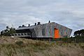
The Edithvale Wetland is looked after by Melbourne Water, while the Seaford Wetland is managed by both Melbourne Water and the City of Frankston. If you visit, you'll find a special bird hide (a hidden spot to watch birds) at the Edithvale Wetland. It has displays to help you learn more. There are also walking and bicycle tracks around both wetlands, perfect for birdwatching.
The bird hide is on Edithvale Road and is staffed by volunteers from the Friends of Edithvale-Seaford Wetlands. It's usually open on Sundays from 1:00 PM to 5:00 PM. The hide was closed for repairs in early 2010 but happily reopened in August 2016.
Images for kids
-
Edithvale-Seaford Wetlands Discovery Centre

