
Edwards County, Illinois facts for kids
Quick facts for kids
Edwards County
|
|
|---|---|

Edwards County Courthouse in Albion
|
|

Location within the U.S. state of Illinois
|
|
 Illinois's location within the U.S. |
|
| Country | |
| State | |
| Founded | 1814 |
| Named for | Ninian Edwards |
| Seat | Albion |
| Largest city | Albion |
| Area | |
| • Total | 223 sq mi (580 km2) |
| • Land | 222 sq mi (570 km2) |
| • Water | 0.3 sq mi (0.8 km2) 0.1% |
| Population
(2020)
|
|
| • Total | 6,245 |
| • Density | 28.00/sq mi (10.813/km2) |
| Time zone | UTC−6 (Central) |
| • Summer (DST) | UTC−5 (CDT) |
| Congressional district | 12th |
Edwards County is a county in the U.S. state of Illinois. In 2020, about 6,245 people lived here. Its main town, or county seat, is Albion.
Contents
History of Edwards County
Edwards County was named after Ninian Edwards. He was an important leader who served as the governor of the Illinois Territory. Later, he became the governor of Illinois.
Edwards County is special because it uses "Road Districts" instead of "Townships". Most counties in Illinois have townships, which are square areas. But Edwards County was settled a long time ago, before these square townships were planned. So, its older Road Districts are still used today.
-
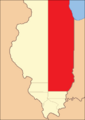
Edwards County was much bigger when it was first created in 1815. It stretched all the way north to Lake Michigan!
-
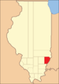
From 1819 to 1821, Crawford County and Wayne County were also created from parts of Edwards County.
-
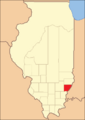
Edwards County looked like this between 1821 and 1824, still changing as new areas were settled.
-
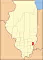
By 1824, Edwards County became its current size. This happened when Wabash County was formed.


Geography of Edwards County
Edwards County covers about 223 square miles. Most of this is land, with only a tiny bit of water. It is one of the smallest counties in Illinois.
When Edwards County was first formed in 1814, it was huge! It covered almost half of what is now the state of Illinois. Over time, new counties were created from its land. By 1824, Edwards County reached its current size. This happened when Wabash County was formed next to it. Edwards and Wabash counties are two of the smallest counties in Illinois.
The Bonpas Creek forms the border between Edwards County and Wabash County.
Weather and Climate in Edwards County
| Weather chart for Albion, Illinois | |||||||||||||||||||||||||||||||||||||||||||||||
|---|---|---|---|---|---|---|---|---|---|---|---|---|---|---|---|---|---|---|---|---|---|---|---|---|---|---|---|---|---|---|---|---|---|---|---|---|---|---|---|---|---|---|---|---|---|---|---|
| J | F | M | A | M | J | J | A | S | O | N | D | ||||||||||||||||||||||||||||||||||||
|
2.6
37
21
|
2.7
44
25
|
4.3
55
35
|
5.1
66
45
|
4.6
76
55
|
4.2
86
64
|
3.9
89
68
|
3.4
88
66
|
2.9
81
58
|
3.4
70
47
|
4.3
54
36
|
3.5
42
26
|
||||||||||||||||||||||||||||||||||||
| temperatures in °F precipitation totals in inches source: The Weather Channel |
|||||||||||||||||||||||||||||||||||||||||||||||
|
Metric conversion
|
|||||||||||||||||||||||||||||||||||||||||||||||
In Albion, the county seat, temperatures change throughout the year. In January, it's usually around 21°F. In July, it can get up to 89°F. The coldest temperature ever recorded was -20°F in January 1982. The hottest was 109°F in July 1954.
The amount of rain and snow also changes. April usually gets the most, about 5.13 inches. January gets the least, around 2.57 inches.
Main Roads in Edwards County
 Illinois Route 1
 Illinois Route 15
 Illinois Route 130
Neighboring Counties
- Richland County (to the north)
- Wabash County (to the east)
- White County (to the south)
- Wayne County (to the west)
Population of Edwards County
| Historical population | |||
|---|---|---|---|
| Census | Pop. | %± | |
| 1820 | 3,444 | — | |
| 1830 | 1,649 | −52.1% | |
| 1840 | 3,070 | 86.2% | |
| 1850 | 3,524 | 14.8% | |
| 1860 | 5,454 | 54.8% | |
| 1870 | 7,565 | 38.7% | |
| 1880 | 8,597 | 13.6% | |
| 1890 | 9,444 | 9.9% | |
| 1900 | 10,345 | 9.5% | |
| 1910 | 10,049 | −2.9% | |
| 1920 | 9,431 | −6.1% | |
| 1930 | 8,303 | −12.0% | |
| 1940 | 8,974 | 8.1% | |
| 1950 | 9,056 | 0.9% | |
| 1960 | 7,940 | −12.3% | |
| 1970 | 7,090 | −10.7% | |
| 1980 | 7,961 | 12.3% | |
| 1990 | 7,440 | −6.5% | |
| 2000 | 6,971 | −6.3% | |
| 2010 | 6,721 | −3.6% | |
| 2020 | 6,245 | −7.1% | |
| 2023 (est.) | 5,968 | −11.2% | |
| U.S. Decennial Census 1790-1960 1900-1990 1990-2000 2010-2017 |
|||

In 2010, there were 6,721 people living in Edwards County. These people lived in about 2,840 homes. Most people in the county are white. A small number of people are from other racial backgrounds. About 1% of the population is of Hispanic or Latino origin.
Many families in Edwards County are married couples living together. About 29% of homes had children under 18. The average age of people in the county was about 42.7 years old.
The average income for a household was around $40,430. For families, it was about $51,337.
Towns and Villages in Edwards County

Cities
- Albion (This is the county seat, where the main government offices are.)
- Grayville (Part of this city is also in White County.)
Villages
Small Communities (Unincorporated)
These are smaller places that don't have their own local government.
Voting Areas (Precincts)
Edwards County is divided into 12 voting areas, called precincts.
- Albion No. 1
- Albion No. 2
- Albion No. 3
- Bone Gap
- Browns
- Dixon
- Ellery
- French Creek
- Salem No. 1
- Salem No. 2
- Shelby No. 1
- Shelby No. 2
See also
 In Spanish: Condado de Edwards (Illinois) para niños
