
Ehime Prefecture facts for kids
Quick facts for kids Ehime Prefecture |
|||||||||
|
|||||||||
 |
|||||||||
| Capital | Matsuyama | ||||||||
| Region | Shikoku | ||||||||
| Island | Shikoku | ||||||||
| Governor | Tokihiro Nakamura (since December 2010) | ||||||||
| Area (rank) | 5,676.44 km² (26th) | ||||||||
| - % water | % | ||||||||
| Population (November 1, 2010) | |||||||||
| - Population | 1,430,086 (27th) | ||||||||
| - Density | 251.93 /km² | ||||||||
| Districts | 7 | ||||||||
| Municipalities | 20 | ||||||||
| ISO 3166-2 | JP-38 | ||||||||
| Website | www.pref.ehime.jp/index-e.htm | ||||||||
| Prefectural Symbols | |||||||||
| - Flower | Satsuma mandarin (Citrus unshiu) | ||||||||
| - Tree | Pine (Pinus) | ||||||||
| - Bird | Japanese robin (Erithacus akahige) | ||||||||
| - Fish | Red sea bream (Pagrus major) | ||||||||
 Symbol of Ehime Prefecture |
|||||||||

Ehime Prefecture (愛媛県 (Ehime-ken)) is a special area in Japan. It is called a prefecture. You can find it in the Shikoku region on the island of Shikoku. The main city, or capital, of Ehime is Matsuyama.
Contents
History of Ehime
Before the year 1868, Ehime Prefecture was known by a different name: Iyo Province. The name "Ehime" comes from an old Japanese book called the Kojiki. It means "beautiful maiden," which sounds lovely!
After a big battle called the Battle of Sekigahara, a powerful leader named the Tokugawa shogun gave this land to his friends. One of these friends, Kato Yoshiaki, built Matsuyama Castle. This castle became the center of what is now the city of Matsuyama.
Sometimes, Ehime has faced long periods without rain, known as droughts. This has been a part of its history.
Ehime's Geography
Ehime is located in the southwestern part of the Shikoku island. It faces the beautiful Seto Inland Sea. To the east, Ehime shares borders with Kagawa Prefecture and Tokushima Prefecture. To the south, it is next to Kōchi.
This prefecture has a very long coastline. Many islands are also part of Ehime. In 1953, the Yanase Dam was built here.
Cities in Ehime
Here are some of the main cities in Ehime Prefecture:
- Imabari
- Iyo
- Matsuyama (This is the capital city!)
- Niihama
- Ōzu
- Saijō
- Seiyo
- Shikokuchūō
- Tōon
- Uwajima
- Yawatahama
Ehime's National Parks
About 7% of all the land in Ehime Prefecture is protected as National Parks. These are special areas kept safe for nature and people to enjoy.
Shrines and Temples
Ōyamazumi jinja is a very important Shinto shrine in Ehime. A Shinto shrine is a place of worship in the traditional Japanese religion called Shinto.
Related pages
- Provinces of Japan
- Prefectures of Japan
- List of regions of Japan
- List of islands of Japan
- Ehime F.C.
Images for kids
-

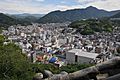
Matsuyama
-
Uwajima
-
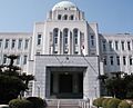
The Ehime Prefectural Capitol Building
-

Ningineer Stadium.
-
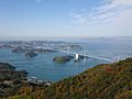
Kurushima Strait Bridge on the Shimanami Kaidō
_in_2010-9-6_No,3.JPG)


See also
 In Spanish: Prefectura de Ehime para niños
