
El Fuerte, Sinaloa facts for kids
Quick facts for kids
El Fuerte
|
|
|---|---|

Constitution Square gazebo
|
|

El Fuerte, Sinaloa
Location in Mexico

El Fuerte, Sinaloa
Location in Sinaloa
|
|
| Country | |
| State | Sinaloa |
| Municipality | El Fuerte |
| Elevation | 90 m (300 ft) |
| Population
(2010)
|
|
| • Total | 12,566 |
| Time zone | UTC-7 (Mountain Standard Time) |
| • Summer (DST) | UTC-6 (Mountain Daylight Time) |
El Fuerte is a city in the northwestern Mexican state of Sinaloa. Its name means "The Fort" in Spanish. In 2010, about 12,566 people lived there.
In 2009, El Fuerte was named a "Magical Town" (Pueblo Mágico). This special title is given to towns that have unique attractions, important history, and a charming old-town feel.
Contents
A Look Back: History of El Fuerte


El Fuerte was founded in 1563 by a Spanish explorer named Francisco de Ibarra. He was the first European to explore the tall Sierra Madre Occidental mountains.
In 1610, a fort was built in the town. This fort helped protect the Spanish settlers from the Zuaque and Tehueco Native American tribes. These tribes often bothered the Spanish.
For many years, El Fuerte was a very important place. It was like a gateway to the northern lands of Sonora, Arizona, and California. These areas were not very populated and had strong native tribes.
For almost 300 years, El Fuerte was the main center for trade and farming in this large region of Mexico. It was a key trading spot for silver and gold miners. These miners came from places like Urique and Batopilas, Chihuahua in the nearby Sierra Madre mountains.
In 1824, El Fuerte became the capital city of a new Mexican state called Sonora y Sinaloa. This state even reached into what is now Arizona. El Fuerte remained the capital for several years. Later, this large state split into two separate states: Sinaloa and Sonora.
Fun Things to Do: Tourism in El Fuerte
Tourism is a big part of El Fuerte's economy. The town celebrates many holidays and local "Fiestas." These events include parades, fairs, and other fun activities.
Several hotels in El Fuerte welcome visitors. Many come for hunting deer, wild boar, and other animals in the nearby hills. Others enjoy fishing in the Rio Fuerte river, which flows near the town.
You can also find ancient petroglyphs (rock carvings) not far from the downtown area. El Fuerte is also a starting point for trips to the famous Barrancas del Cobre (Copper Canyon). This huge canyon is located in the nearby state of Chihuahua.
Getting Around: Transportation
Riding the Rails: The ChePe Train
Many visitors travel to El Fuerte by train. They take the Ferrocarril Chihuahua al Pacífico railway, often called the ChePe. The local train station is a few miles south of the town.
The ChePe train route is very scenic. It passes through the beautiful Copper Canyon. The train goes from Chihuahua, Chihuahua in the northeast to Los Mochis, Sinaloa in the southwest. Los Mochis is close to the Gulf of California.
| Preceding station | Ferromex | Following station | ||
|---|---|---|---|---|
| Sufragio
toward Los Mochis
|
Chepe Regional | Loreto
toward Chihuahua
|
||
| Los Mochis
Terminus
|
Chepe Express | Bahuichivo-Cerocahui
toward Creel-Sierra Tarahumara
|
||
| Former services | ||||
| Preceding station | Following station | |||
| Norotes
toward Topolobampo
|
El Chepe | Ing. Heriberto Valdez
toward Ojinaga
|
||
Flying In: El Fuerte Airport
El Fuerte also has its own airport. It is called El Fuerte Airport.
Weather in El Fuerte: Climate
| Climate data for El Fuerte (1951–2010) | |||||||||||||
|---|---|---|---|---|---|---|---|---|---|---|---|---|---|
| Month | Jan | Feb | Mar | Apr | May | Jun | Jul | Aug | Sep | Oct | Nov | Dec | Year |
| Record high °C (°F) | 38.5 (101.3) |
39.5 (103.1) |
42.0 (107.6) |
44.0 (111.2) |
46.0 (114.8) |
45.5 (113.9) |
45.5 (113.9) |
46.0 (114.8) |
44.5 (112.1) |
44.0 (111.2) |
42.0 (107.6) |
39.0 (102.2) |
46.0 (114.8) |
| Mean daily maximum °C (°F) | 27.7 (81.9) |
29.2 (84.6) |
31.6 (88.9) |
34.8 (94.6) |
37.8 (100.0) |
39.6 (103.3) |
37.7 (99.9) |
36.5 (97.7) |
36.5 (97.7) |
35.8 (96.4) |
32.0 (89.6) |
28.3 (82.9) |
34.0 (93.2) |
| Daily mean °C (°F) | 17.6 (63.7) |
18.6 (65.5) |
20.3 (68.5) |
23.2 (73.8) |
26.5 (79.7) |
30.8 (87.4) |
30.9 (87.6) |
30.0 (86.0) |
29.6 (85.3) |
26.9 (80.4) |
21.8 (71.2) |
18.2 (64.8) |
24.5 (76.1) |
| Mean daily minimum °C (°F) | 7.5 (45.5) |
8.0 (46.4) |
9.0 (48.2) |
11.6 (52.9) |
15.2 (59.4) |
21.9 (71.4) |
24.1 (75.4) |
23.5 (74.3) |
22.8 (73.0) |
18.1 (64.6) |
11.5 (52.7) |
8.1 (46.6) |
15.1 (59.2) |
| Record low °C (°F) | −3.5 (25.7) |
−4.5 (23.9) |
−0.5 (31.1) |
2.0 (35.6) |
6.0 (42.8) |
10.5 (50.9) |
13.0 (55.4) |
10.0 (50.0) |
15.0 (59.0) |
8.0 (46.4) |
−1.0 (30.2) |
−5.0 (23.0) |
−5.0 (23.0) |
| Average precipitation mm (inches) | 28.2 (1.11) |
14.7 (0.58) |
6.7 (0.26) |
2.8 (0.11) |
2.6 (0.10) |
33.0 (1.30) |
169.5 (6.67) |
176.2 (6.94) |
103.6 (4.08) |
32.3 (1.27) |
17.8 (0.70) |
26.6 (1.05) |
614.0 (24.17) |
| Average precipitation days (≥ 0.1 mm) | 2.8 | 1.9 | 0.9 | 0.6 | 0.4 | 3.0 | 13.7 | 12.9 | 7.5 | 2.9 | 1.7 | 2.8 | 51.1 |
| Source: Servicio Meteorologico Nacional | |||||||||||||
Images for kids
-
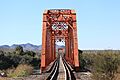
Railway across El Fuerte
-
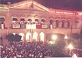
City Hall during El Grito
.jpg)
_(18238040195).jpg)
Sister Cities
El Fuerte has a special friendship with another city:
See also
 In Spanish: El Fuerte (Sinaloa) para niños
