Ellington, New York facts for kids
Quick facts for kids
Ellington, New York
|
|
|---|---|
| Nickname(s):
"A Grand Old Town"
|
|

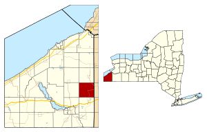
Location within Chautauqua County and New York
|
|
| Country | United States |
| State | New York |
| County | Chautauqua |
| Government | |
| • Type | Town Council |
| Area | |
| • Total | 36.56 sq mi (94.69 km2) |
| • Land | 36.55 sq mi (94.65 km2) |
| • Water | 0.01 sq mi (0.04 km2) |
| Elevation | 1,411 ft (430 m) |
| Population
(2020)
|
|
| • Total | 1,493 |
| • Estimate
(2021)
|
1,500 |
| • Density | 43.07/sq mi (16.63/km2) |
| Time zone | UTC-5 (Eastern (EST)) |
| • Summer (DST) | UTC-4 (EDT) |
| ZIP code |
14732
|
| Area code(s) | 716 |
| FIPS code | 36-013-24053 |
| GNIS feature ID | 0978935 |
Ellington is a small town located in Chautauqua County, New York, United States. In 2020, about 1,493 people lived there.
Contents
History of Ellington
The town of Ellington was officially created on April 1, 1824. It was formed from parts of the towns of Gerry and Cherry Creek. The first people to settle in the area arrived around 1814. Joshua Bentley was one of the first settlers.
The very first town meeting for Ellington happened on March 1, 1825. It was held at the home of Lucretia French. Religious services began even earlier, in 1817, at James Bates' house.
In its early days, Ellington had several saw-mills. These mills were important for cutting wood. One famous saw-mill on Mill Street worked from the 1800s until the early 2000s.
Ellington also had its own high school, called The Ellington Academy. It was built in 1910 on Main Street. Before that, an older school house from 1852 was known as "The Box of Knowledge." The Academy stopped being a high school in 1948. Today, the building is a private home.
The Floods of Ellington
Ellington has experienced some big floods. On September 8, 1865, a storm caused Twenty-eighth Creek to overflow. This creek runs through the southern part of the town. Many homes, stores, and even the Baptist Church were damaged or washed away.
Another major flood happened on August 2, 1979. Again, Twenty-eighth Creek caused a lot of damage. Floodwaters rushed through the town, damaging about 40 homes. The Baptist Church and the old town hall were also affected. Town records from the hall were found far away. This flood caused about one million dollars in damage. A smaller flood happened just a month later, on September 14, 1979.
Geography of Ellington
Ellington is located on the eastern side of Chautauqua County. It shares a border with Cattaraugus County to the east. The town is northeast of Jamestown, which is the largest city in Chautauqua County.
The total area of Ellington is about 94.7 square kilometers (36.6 square miles). Only a very small part of this, about 0.04 square kilometers (0.01 square miles), is water.
Major roads pass through Ellington. U.S. Route 62 goes from east to south through the town. New York State Route 83 runs through the northeast part of town. It follows along Conewango Creek, which flows into the Allegheny River.
Nearby Towns and Areas
Ellington is located:
- North of the town of Poland.
- South of the town of Cherry Creek.
- West of the town of Gerry.
- East of the town of Conewango in Cattaraugus County.
Population of Ellington
| Historical population | |||
|---|---|---|---|
| Census | Pop. | %± | |
| 1830 | 1,279 | — | |
| 1840 | 1,725 | 34.9% | |
| 1850 | 2,001 | 16.0% | |
| 1860 | 1,937 | −3.2% | |
| 1870 | 1,556 | −19.7% | |
| 1880 | 1,602 | 3.0% | |
| 1890 | 1,430 | −10.7% | |
| 1900 | 1,330 | −7.0% | |
| 1910 | 1,235 | −7.1% | |
| 1920 | 1,061 | −14.1% | |
| 1930 | 1,079 | 1.7% | |
| 1940 | 1,073 | −0.6% | |
| 1950 | 1,142 | 6.4% | |
| 1960 | 1,314 | 15.1% | |
| 1970 | 1,384 | 5.3% | |
| 1980 | 1,690 | 22.1% | |
| 1990 | 1,615 | −4.4% | |
| 2000 | 1,639 | 1.5% | |
| 2010 | 1,643 | 0.2% | |
| 2020 | 1,493 | −9.1% | |
| 2021 (est.) | 1,500 | −8.7% | |
| U.S. Decennial Census | |||
In the year 2000, there were 1,639 people living in Ellington. These people lived in 568 households. A household is a group of people living together in one home. Most households, 66.9%, were married couples. About 36.3% of households had children under 18 living with them.
The population was spread out by age. About 28.4% of the people were under 18 years old. The average age in Ellington was 37 years. For every 100 females, there were about 101 males.
The average yearly income for a household in Ellington was $36,300 in 2000.
Ellington Town Picnic
Every year, Ellington hosts its famous "Ellington Town Picnic." This fun event takes place on the first Friday, Saturday, and Sunday of August.
The picnic has many exciting activities. These include a woodcutting contest and a cake contest. There's also a pet show and a baby contest. People can join a horseshoe throwing contest. There is also a BBQ, square dancing, and music. On Saturday night at 10:00 PM, there is a wonderful fireworks show. It happens near the northeast side of the town park.
History of the Town Picnic
The first official Town Picnic was held in 1905. People would arrive by horse and buggy, bringing food to share. As electricity came to Ellington, the event grew. It changed from a one-day gathering to the three-day event it is today.
For a few years, politicians gave speeches at the picnic. However, this practice was soon stopped. This picnic has been held almost every year since 1912. It only stopped during the World Wars. This makes it one of the oldest small-town picnics in America!
Notable People from Ellington
Ellington has been home to some interesting people:
- William Parment – He was a former New York State Assemblyman. This means he helped make laws for New York State.
- Bill Rexford – He was a famous race car driver. He won the 1950 Nascar Grand National Series Championship.
- James Strang – He was a religious leader. He also called himself the "King of the United States."
Communities and Locations in Ellington
Here are some of the smaller communities and places you can find in the town of Ellington:
- Bates – A small village in the northwest part of town.
- Clear Creek – A village on the eastern edge of the town. It is south of Conewango Valley.
- Clear Creek – This is also the name of a stream. It flows eastward and is part of the Allegheny River system.
- Conewango Valley – A village on the eastern town line. The post office here is actually in the nearby town of Conewango.
- Ellington – This is the main village in the center of the town.
- Gates Corners – A place located near the northern border of the town.
- Kings School Corner – Another location near the northern town line.
- Waterboro – A village located in the southeast part of the town.
See also
 In Spanish: Ellington (Nueva York) para niños
 | Audre Lorde |
 | John Berry Meachum |
 | Ferdinand Lee Barnett |


