Emerson, New Jersey facts for kids
Quick facts for kids
Emerson, New Jersey
|
||
|---|---|---|
|
Borough
|
||
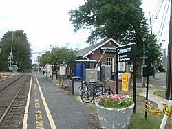
NJ Transit station in Emerson
|
||
|
||
| Nickname(s):
"The Family Town"
|
||
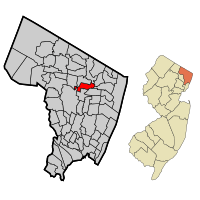
Location of Emerson in Bergen County highlighted in red (left). Inset map: Location of Bergen County in New Jersey highlighted in orange (right).
|
||
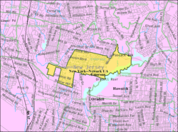
Census Bureau map of Emerson, New Jersey
|
||
| Country | ||
| State | ||
| County | Bergen | |
| Incorporated | April 8, 1903 (as Etna) | |
| Name changed | March 9, 1909 (to Emerson) | |
| Named for | Ralph Waldo Emerson | |
| Government | ||
| • Type | Borough | |
| • Body | Borough Council | |
| Area | ||
| • Total | 2.42 sq mi (6.27 km2) | |
| • Land | 2.23 sq mi (5.78 km2) | |
| • Water | 0.19 sq mi (0.49 km2) 7.85% | |
| Area rank | 379th of 565 in state 40th of 70 in county |
|
| Elevation | 49 ft (15 m) | |
| Population
(2020)
|
||
| • Total | 7,290 | |
| • Estimate
(2023)
|
7,251 | |
| • Rank | 311th of 565 in state 51st of 70 in county |
|
| • Density | 3,267.6/sq mi (1,261.6/km2) | |
| • Density rank | 205th of 565 in state 43rd of 70 in county |
|
| Time zone | UTC−05:00 (Eastern (EST)) | |
| • Summer (DST) | UTC−04:00 (Eastern (EDT)) | |
| ZIP Code |
07630
|
|
| Area code(s) | 201 | |
| FIPS code | 3400321450 | |
| GNIS feature ID | 0885208 | |
Emerson is a small town, called a borough, in Bergen County, New Jersey. It's like a suburb that's part of the big New York City metropolitan area. Emerson is the most southern town in a part of the county known as the Pascack Valley.
In 2020, about 7,290 people lived in Emerson. This was a small decrease from 7,401 people in 2010.
Emerson was first created on April 8, 1903. It was called the Borough of Etna back then. The name came from a local train station. On March 9, 1909, the name was changed to Emerson. It was named after the famous writer Ralph Waldo Emerson. The town even calls itself "The Family Town."
Contents
Where is Emerson?
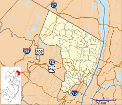
Emerson is located in New Jersey. It covers about 2.42 square miles (6.27 square kilometers). Most of this area is land, and a small part is water.
Some smaller places and names within Emerson include Old Hook.
Emerson shares borders with several other towns in Bergen County. These include Closter, Harrington Park, Haworth, Oradell, Paramus, River Vale, Washington Township, and Westwood.
How Many People Live Here?
| Historical population | |||
|---|---|---|---|
| Census | Pop. | %± | |
| 1900 | 456 | — | |
| 1910 | 767 | 68.2% | |
| 1920 | 973 | 26.9% | |
| 1930 | 1,394 | 43.3% | |
| 1940 | 1,487 | 6.7% | |
| 1950 | 1,744 | 17.3% | |
| 1960 | 6,849 | 292.7% | |
| 1970 | 8,428 | 23.1% | |
| 1980 | 7,793 | −7.5% | |
| 1990 | 6,930 | −11.1% | |
| 2000 | 7,197 | 3.9% | |
| 2010 | 7,401 | 2.8% | |
| 2020 | 7,290 | −1.5% | |
| 2023 (est.) | 7,251 | −2.0% | |
| Population sources: 1910–1920 1910 1910–1930 1900–2020 2000 2010 2020 |
|||
2010 Census Information
In 2010, the 2010 United States census counted 7,401 people living in Emerson. There were 2,480 households, which are groups of people living together.
Most of the people (87.31%) were White. About 8.55% were Asian, and 1.08% were Black or African American. People of Hispanic or Latino background made up 8.36% of the population.
About 23.9% of the people were under 18 years old. The average age in Emerson was 44.3 years.
The average income for a household in Emerson was about $99,292 in 2010. For families, the average income was about $108,300.
Economy
Emerson has a shopping center called Pascack Valley Shopping Center. It is located on Kinderkamack Road. In the past, it had a movie theater and a bowling alley.
Parks and Fun Places
Emerson has several parks where people can relax and play:
- Ackerman Park: You can find this park on Ackerman Avenue. It has a playground, basketball courts, a bocce court, and a picnic area.
- Centennial Park: This park is on Main Street. It has a gazebo and a walking path. There's also a community garden for residents that opened in 2017. The park was named Centennial Park in 2003 to celebrate Emerson's 100th birthday.
- Hillman Park: Located on Thomas Street, this park was given to the town by a resident named Richard Hillman. It has baseball fields, including Ken Benkovic Jr. Memorial Field and Babes Field, which are both lighted. There's also a soccer field and a playground. The town's library and community center are next to this park.
- Rosengart Park: Sometimes called "Sunset Park," this park is on Sunset Place and has a playground.
- Veterans' Park: This is a special memorial park on High Street. It has monuments that honor veterans from Emerson.
- Washington Park: You can find this park on Washington Avenue. It's a historic spot where General Washington camped a long time ago. It has a playground and a picnic area.
- Emerson Woods: This is a large wooded area, about 19 acres, along Main Street. It was saved from being developed into townhouses. Now, it has trails for visitors to explore nature.
Schools in Emerson
The Emerson School District teaches students from pre-kindergarten all the way through twelfth grade. In the 2021–22 school year, about 1,085 students attended the three schools in the district.
The schools are:
- Memorial Elementary School: For students in PreK-2.
- Patrick M. Villano Elementary School: For students in grades 3-6.
- Emerson Junior-Senior High School: For students in grades 7-12.
Students in Bergen County can also go to special high school programs. These are offered by the Bergen County Technical Schools. They include the Bergen County Academies in Hackensack and the Bergen Tech campus in Teterboro or Paramus. These programs are for students who apply and are accepted.
Assumption Academy, a Catholic school, closed its elementary program in June 2012. This was because fewer students were enrolling.
Getting Around Emerson
Emerson has many roads. In 2010, there were about 30.87 miles of roads. Most of these were kept up by the town itself.
The main roads in Emerson are County Route 502 (Old Hook Road) and County Route 503 (Kinderkamack Road).
Public Transportation
The Emerson train station is on Kinderkamack Road. You can catch an NJ Transit train there on the Pascack Valley Line. This line goes to Hoboken Terminal. From Hoboken, you can connect to other trains to places like New York Penn Station. You can also take the PATH train, ferries, or the Hudson-Bergen Light Rail.
NJ Transit also has bus service on the 165 route. This bus goes to and from the Port Authority Bus Terminal in Midtown Manhattan.
Another bus company, Rockland Coaches, has routes 11A/11AT. These also go to the Port Authority Bus Terminal and to Rockland County, New York.
A School Safety Event
On September 19, 2007, there was a safety concern for the Emerson School System. A letter was sent to the Mayor, saying that all three schools might be in danger the next day.
Because of this, all three Emerson Schools were quickly evacuated. Students and teachers left their belongings behind to ensure everyone's safety.
Police and a bomb squad searched the schools in Emerson. They also searched schools in nearby towns like Oradell and Washington Township. Nothing dangerous was found.
As a safety measure, thirteen school districts, including Emerson, closed their schools on September 20, 2007. This affected many students. The schools stayed closed for two days until they were confirmed to be safe.
Interesting Places to Visit
- Cedar Park Cemetery: A cemetery located in Emerson.
- Emerson Public Library: This library started in 1957 and moved to its current building in 1974.
- Soldier Hill Golf Club: This golf course opened in 1963. It covers parts of both Emerson and Oradell, near the Oradell Reservoir.
Famous People from Emerson
People who have lived in or are connected to Emerson include:
- Aron Abrams (1960–2010), a writer for movies and TV.
- Nicki Gross (born 1989), an assistant coach for a basketball team called the Iowa Energy.
- Kevin Higgins (born 1955), an assistant football coach at Wake Forest University.
- Sonny Igoe (1923–2012), a jazz drummer.
- Andy Papathanassiou, who helps manage the pit crew for NASCAR's Hendrick Motorsports racing team.
See also
 In Spanish: Emerson (Nueva Jersey) para niños
 | Claudette Colvin |
 | Myrlie Evers-Williams |
 | Alberta Odell Jones |


