
Ena Lake, Ontario facts for kids
Quick facts for kids
Ena Lake
|
|
|---|---|

Ena Lake
Location in Ontario
|
|
| Country | Canada |
| Province | Ontario |
| Region | Northwestern Ontario |
| District | Kenora |
| Part | Kenora, Unorganized |
| Elevation | 335 m (1,099 ft) |
| Time zone | UTC-6 (Central Time Zone) |
| • Summer (DST) | UTC-5 (Central Time Zone) |
| Postal code FSA |
P0X
|
| Area code(s) | 807 |
| Ena Lake | |
|---|---|

Ena Lake
Location in Ontario
|
|
| Location | Kenora District, Ontario, Canada |
| Coordinates | 49°58′56″N 94°30′57″W / 49.982235°N 94.515817°W |
| Primary inflows | Octopus Creek, MacFarlane River |
| Primary outflows | MacFarlane River |
| Basin countries | Canada |
| Average depth | 10 ft (3.0 m) |
| Max. depth | 75 ft (23 m) |
| Surface elevation | 1,125 ft (343 m) |
Ena Lake is a beautiful lake and a small community in Ontario, Canada. It is located in the northwestern part of the province, about 23 kilometers (14 miles) north of the city of Kenora. Ena Lake used to be a stop on the Canadian National Railway. Today, it is a quiet place where about 50 people spend their summers in cottages. A few people, around 11, live there all year round.
Contents
Geography of Ena Lake
Ena Lake is a typical lake found in the Canadian Shield region. The Canadian Shield is a large area of ancient rock. Because of this, the lake's shores are rocky, with many tall ridges and hills around it. The water in Ena Lake is very clear and cool.
Water Flow
Water flows into Ena Lake from two main sources. These are Octopus Creek, also known as "Ena Brook," and the MacFarlane River, which locals call "Corn Creek." The MacFarlane River also flows out of Ena Lake. There is a small dam that controls the water flow. Below the dam, you can find exciting rapids and waterfalls. The MacFarlane River eventually joins the Winnipeg River. This means Ena Lake is part of a huge water system that leads to the Nelson River and finally to Hudson Bay.
Getting to Ena Lake
You can reach Ena Lake from Kenora by driving on Ontario Highway 658 and then taking Ena Lake Road. The lake is also located along the main railway line of the Canadian National Railway. This line connects different parts of Canada. Even though trains pass by, they don't stop there anymore.
You can also get to Ena Lake by boat. You can travel along the Winnipeg River and then the MacFarlane River. From there, a short portage (carrying your boat over land) leads to the lake. The portage path is right next to the dam at the lake's outflow. It even crosses the road, where a sign shows the way. It's also possible to take boat trips from Ena Lake to Redditt by following the MacFarlane River and Corn Lake.
Wildlife and Nature
Ena Lake is a great place to see different kinds of wildlife.
Birds
In the spring, many white pelicans come to Ena Lake. They gather in large groups to fish for spawning fish in the rapids below the waterfalls. Sometimes, you can see as many as 200 pelicans at once! The areas where Octopus Creek and Corn Creek flow into the lake are wetlands. These are marshy areas with floating bogs, which are special types of spongy ground.
Fish and Other Animals
The lake is home to several types of fish, including smallmouth bass, walleye, and northern pike. Along the shores, you might spot larger animals like whitetail deer, moose, and black bears. Beavers are also common, especially along Ena Brook and Corn Creek, where you can see their active lodges (homes).
Fun Things to Do
Ena Lake is a popular spot for people who love to go canoeing. It's a great starting point for canoe trips to nearby lakes like Vermillion Lake and Octopus Lake, and even further.
Images for kids
-
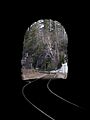
View from inside the CNR tunnel, looking east
-
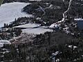
Dam and landing at Ena Lake


