
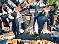
Endingen am Kaiserstuhl facts for kids
Quick facts for kids
Endingen
|
||
|---|---|---|
|
||
| Country | Germany | |
| State | Baden-Württemberg | |
| Admin. region | Freiburg | |
| District | Emmendingen | |
| Elevation | 186 m (610 ft) | |
| Population
(2022-12-31)
|
||
| • Total | 10,532 | |
| Time zone | CET/CEST (UTC+1/+2) | |
| Postal codes |
79346
|
|
| Dialling codes | 07642 | |
| Vehicle registration | EM | |
| Website | www.endingen.de | |

Endingen is a small German town in southwest Germany. It is located near the border with France. The town sits at the northern edge of a special area called Kaiserstuhl. This area was once a volcano! About 9,000 people live in Endingen.
Contents
Exploring Endingen, Germany
Where is Endingen Located?
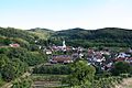
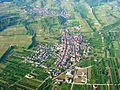
The town of Endingen includes the main town and three smaller villages. These villages are Amoltern, Kiechlinsbergen, and Königschaffhausen. They are all found in the northern part of the Kaiserstuhl region.
The highest point in Endingen is the Katharinenberg. It is in the south of the town. A chapel stands at the top of this hill. At 492.4 meters (about 1,615 feet) high, it is the third tallest peak in the Kaiserstuhl area.
What's the Weather Like in Endingen?
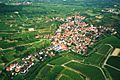
Endingen is in one of the warmest parts of Germany. This warm weather is great for growing grapes! The grapes grown here make high-quality wines.
The climate here is similar to a Mediterranean climate. It gets enough rain all year round. However, it rains more here than in the nearby Rhine area. This is because Endingen is close to the Black Forest. The climate is generally mild and pleasant.
| Climate data for Endingen (Emmendingen-Mundingen) 2015-2020 | |||||||||||||
|---|---|---|---|---|---|---|---|---|---|---|---|---|---|
| Month | Jan | Feb | Mar | Apr | May | Jun | Jul | Aug | Sep | Oct | Nov | Dec | Year |
| Record high °C (°F) | 15.9 (60.6) |
20.3 (68.5) |
24.0 (75.2) |
29.5 (85.1) |
33.3 (91.9) |
37.1 (98.8) |
37.7 (99.9) |
38.5 (101.3) |
32.3 (90.1) |
28.1 (82.6) |
23.8 (74.8) |
18.0 (64.4) |
38.5 (101.3) |
| Mean daily maximum °C (°F) | 6.2 (43.2) |
8.1 (46.6) |
12.8 (55.0) |
17.0 (62.6) |
20.7 (69.3) |
25.4 (77.7) |
27.5 (81.5) |
26.4 (79.5) |
22.6 (72.7) |
16.3 (61.3) |
10.7 (51.3) |
7.9 (46.2) |
16.8 (62.2) |
| Daily mean °C (°F) | 2.7 (36.9) |
3.5 (38.3) |
6.9 (44.4) |
10.5 (50.9) |
14.7 (58.5) |
19.2 (66.6) |
21.1 (70.0) |
20.0 (68.0) |
15.5 (59.9) |
10.7 (51.3) |
6.4 (43.5) |
4.1 (39.4) |
11.3 (52.3) |
| Mean daily minimum °C (°F) | −1.1 (30.0) |
−0.4 (31.3) |
1.3 (34.3) |
3.7 (38.7) |
8.4 (47.1) |
12.9 (55.2) |
13.8 (56.8) |
13.0 (55.4) |
9.2 (48.6) |
5.6 (42.1) |
2.1 (35.8) |
0.3 (32.5) |
5.8 (42.4) |
| Record low °C (°F) | −15.5 (4.1) |
−12.1 (10.2) |
−5.2 (22.6) |
−3.3 (26.1) |
1.7 (35.1) |
5.9 (42.6) |
5.7 (42.3) |
5.7 (42.3) |
0.6 (33.1) |
−2.5 (27.5) |
−6.9 (19.6) |
−6.7 (19.9) |
−6.8 (19.8) |
| Average precipitation mm (inches) | 63 (2.5) |
44 (1.7) |
43 (1.7) |
69 (2.7) |
119 (4.7) |
93 (3.7) |
47 (1.9) |
73 (2.9) |
52 (2.0) |
47 (1.9) |
55 (2.2) |
44 (1.7) |
749 (29.5) |
| Average precipitation days (≥ 0.2 mm) | 14.9 | 13.4 | 16.0 | 13.0 | 15.1 | 12.3 | 15.1 | 14.8 | 11.7 | 15.7 | 16.7 | 15.3 | 173.9 |
| Average rainy days (≥ 0.2 mm) | 13 | 10 | 15 | 14 | 17 | 16 | 12 | 13 | 11 | 14 | 14 | 14 | 163 |
| Average snowy days (≥ 0.2 cm) | 3.4 | 0.8 | 0.4 | 0.2 | 0 | 0 | 0 | 0 | 0 | 0 | 0.4 | 3.0 | 8.2 |
| Mean monthly sunshine hours | 71.7 | 96.3 | 136.3 | 167.5 | 199.5 | 249.6 | 238.9 | 219.9 | 165.9 | 117.3 | 70.6 | 60.3 | 1,793.8 |
| Source 1: Weather-Online | |||||||||||||
| Source 2: Weather-Online | |||||||||||||
Neighboring Towns and Villages
Endingen is surrounded by several other communities. These include Sasbach, Wyhl, Forchheim, Riegel, Bahlingen, and Vogtsburg.
How Endingen is Organized
Endingen is made up of the main town and three districts: Amoltern, Kiechlinsbergen, and Königschaffhausen. Each of these districts has its own local council and mayor. They also have their own administration offices. These districts used to be separate towns before they became part of Endingen.
-
Endingen
-
Amoltern
-
Kiechlinsbergen
-
Königschaffhausen


A Look at Endingen's History

Endingen was first mentioned in old records in the year 862. For many centuries, different powerful families owned the town. First, it belonged to the Lords of Endingen. Then, it was owned by the Lords of Üsenberg.
Around 1285 or 1286, Endingen was given special "city rights." This meant it could govern itself more. When the Lords of Üsenberg family ended in 1379, the town became part of the Habsburgs' lands. For a short time in the 1400s, Endingen was even a "Free Imperial City." This meant it was directly under the Holy Roman Emperor.
In 1751, Endingen was the location of a sad event. A woman named Anna Schnidenwind was accused of witchcraft and executed. This was one of the last times such an event happened in Europe. After 1805, Endingen became part of the region called Baden. It also became part of the Landkreis Emmendingen district.
In 1843, many people from the Kaiserstuhl area, including Endingen, moved far away. About 358 citizens traveled to Colonia Tovar, Venezuela. They built houses in a traditional German style. They also started farms and even brewed Venezuela's first beer!
When Villages Joined Endingen
Over time, the nearby villages became part of Endingen:
-
Amoltern
-
Kiechlinsbergen
-
Königschaffhausen


- December 1, 1971: Amoltern joined Endingen.
- January 1, 1974: Kiechlinsbergen joined Endingen.
- January 1, 1975: Königschaffhausen joined Endingen.
Fun Places to Visit in Endingen
If you visit Endingen, you can explore some interesting museums:
- The Kaiserstühler Heimatmuseum teaches about the local history.
- There is a Cheese museum in Endingen.
- You can also visit the Further Austria museum.
Endingen's Economy and How it Works
What Endingen is Known For
Growing grapes for wine is very important in Endingen. Just like everywhere else in the Kaiserstuhl area, wine is a big part of the economy. There are wine cooperatives in each village and in the main town. Many independent wineries also operate here. Königschaffhausen is especially famous for growing cherries. Endingen also has various industrial and retail businesses.
Learning in Endingen
Endingen has good schools for kids of all ages.
- For younger children, there are three kindergartens in the town center. Each of the wine-growing villages also has its own kindergarten.
- The Endingen school center has an elementary school. It also has classes for grades 5 to 7.
- The Maria Sibylla Merian Primary School serves elementary students from Kiechlinsbergen and Königschaffhausen.
- There is also the Albert Schweitzer-Förderschule. This school helps students who have learning difficulties.
Getting Around Endingen
Endingen is located south of the state road L113. The city is only about 5 kilometers (3 miles) from the A5 motorway. This major highway connects cities like Frankfurt am Main and Basel.
The town has a train station on the Kaiserstuhl Railway. You can take direct trains to places like Riegel-Malterdingen. From there, you can connect to other train lines. The closest airport is the EuroAirport Basel-Mulhouse-Freiburg. It is about 70 kilometers (43 miles) south of Endingen.
Endingen's Sister Cities
Endingen has special friendships with other towns around the world. These are called "twin towns" or "sister cities."
 Erstein, France
 Colonia Tovar, Venezuela
Since 1970, Endingen has been twinned with the French town of Erstein. Erstein is only about 30 kilometers (18 miles) away, across the Rhine River. Endingen also has a twinning with Colonia Tovar in Venezuela. This is because some people from Endingen helped to start that community long ago. Endingen also has friendly connections with the French town of Coulonges-sur-l'Autize.
Famous People Connected to Endingen
Born in Endingen am Kaiserstuhl
- Joseph Biechele - He created the famous Biechele Soap brand.
- Augustin Tünger (1455-not after 1510) - He wrote the first German collection of funny stories.
- Anton Benitz (1803-1858) - He started the Benitz Brewery in Pittsburgh, USA. This brewery later became the Iron City Brewery, which is still in business today!
People Connected to Endingen
- Oskar Daubmann (1898-1954)
- Anna Schnidenwind (1688-1751)
See also
 In Spanish: Endingen am Kaiserstuhl para niños
