Eubank, Kentucky facts for kids
Quick facts for kids
Eubank, Kentucky
|
|
|---|---|

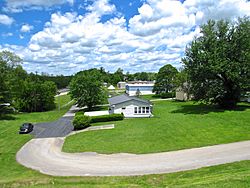
Houses in Eubank
|
|

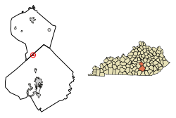
Location in Pulaski and Lincoln counties, Kentucky
|
|
| Country | United States |
| State | Kentucky |
| Counties | Pulaski, Lincoln |
| Area | |
| • Total | 0.85 sq mi (2.21 km2) |
| • Land | 0.85 sq mi (2.19 km2) |
| • Water | 0.01 sq mi (0.01 km2) |
| Elevation | 1,188 ft (362 m) |
| Population
(2020)
|
|
| • Total | 313 |
| • Density | 369.54/sq mi (142.65/km2) |
| Time zone | UTC-5 (Eastern (EST)) |
| • Summer (DST) | UTC-4 (EDT) |
| ZIP code |
42567
|
| Area code(s) | 606 |
| FIPS code | 21-25552 |
| GNIS feature ID | 2403573 |
Eubank is a small city in Kentucky, located in both Pulaski and Lincoln counties. It's known as a "home rule-class city," which means it has some power to govern itself.
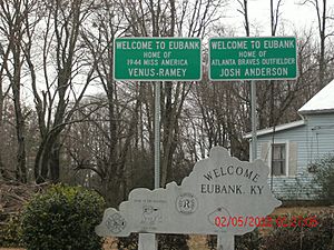
In 2010, about 319 people lived in Eubank. The part of Eubank in Pulaski County is near the larger city of Somerset. The Lincoln County part is close to Danville. Eubank has been home to some notable people, including former baseball player Josh Anderson and Venus Ramey, who was Miss America in 1944.
Contents
History of Eubank
How Eubank Got Its Name
The town of Eubank was named after a person called Wesley Eubank. He owned land in the area. The name "Eubanks" is also sometimes used for the town.
Early Development and Railroads
Eubank became an important stop along the Cincinnati Southern Railroad. This railroad helped the town grow and connect with other places. In 1886, the state assembly of Kentucky officially recognized Eubank as a town.
Geography of Eubank
Where is Eubank Located?
Eubank is mainly located in the northern part of Pulaski County. A small section of the city stretches north into Lincoln County. The city's main area is around where two roads, Kentucky Route 1247 and Kentucky Route 70, meet.
Nearby Cities and Roads
U.S. Route 27 runs along the eastern side of Eubank. This road can take you about 14 miles (22.5 km) south to Somerset, which is the main town for Pulaski County. If you go north on U.S. Route 27 for about 18 miles (29 km), you'll reach Stanford, the main town for Lincoln County.
Kentucky Route 70 also connects Eubank to other towns. You can travel about 23 miles (37 km) east to Mount Vernon or about 24 miles (38.6 km) west to Liberty.
Land and Water Area
Eubank covers a total area of about 2.2 square kilometers (0.85 square miles). Most of this area is land. Only a very small part, about 0.01 square kilometers (0.004 square miles), is water.
Population of Eubank
How Many People Live Here?
| Historical population | |||
|---|---|---|---|
| Census | Pop. | %± | |
| 1910 | 182 | — | |
| 1920 | 312 | 71.4% | |
| 1930 | 334 | 7.1% | |
| 1940 | 303 | −9.3% | |
| 1950 | 322 | 6.3% | |
| 1960 | 303 | −5.9% | |
| 1970 | 230 | −24.1% | |
| 1980 | 207 | −10.0% | |
| 1990 | 354 | 71.0% | |
| 2000 | 358 | 1.1% | |
| 2010 | 319 | −10.9% | |
| 2020 | 313 | −1.9% | |
| U.S. Decennial Census | |||
According to the 2000 census, there were 358 people living in Eubank. These people lived in 141 households, and 102 of these were families. The city had about 395 people per square mile (152 people per square kilometer).
Who Lives in Eubank?
Most of the people in Eubank are White (97.77%). A smaller number are Native American (1.68%) or from two or more races (0.56%).
About 31.2% of households had children under 18 living with them. Many households (55.3%) were married couples. Some households (14.9%) had a female head with no husband present. About 14.2% of households had someone living alone who was 65 years old or older.
The average household had about 2.54 people, and the average family had about 3.06 people.
Age Groups in Eubank
The population of Eubank includes people of all ages. About 26.3% of the people were under 18 years old. About 8.9% were between 18 and 24 years old. The largest group, 29.3%, was between 25 and 44 years old. About 14.5% of the people were 65 years old or older. The average age in Eubank was 35 years.
See also
 In Spanish: Eubank (Kentucky) para niños
 | Stephanie Wilson |
 | Charles Bolden |
 | Ronald McNair |
 | Frederick D. Gregory |


