Liberty, Kentucky facts for kids
Quick facts for kids
Liberty, Kentucky
|
|
|---|---|

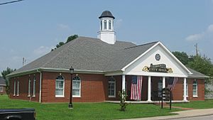
City Hall
|
|

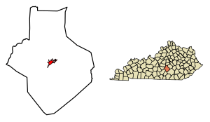
Location of Liberty in Casey County, Kentucky.
|
|
| Country | United States |
| State | Kentucky |
| County | Casey |
| Incorporated | 1860 |
| Area | |
| • Total | 1.89 sq mi (4.88 km2) |
| • Land | 1.87 sq mi (4.85 km2) |
| • Water | 0.01 sq mi (0.04 km2) |
| Elevation | 810 ft (250 m) |
| Population
(2020)
|
|
| • Total | 2,028 |
| • Estimate
(2022)
|
2,011 |
| • Density | 1,083.91/sq mi (418.50/km2) |
| Time zone | UTC-5 (Eastern (EST)) |
| • Summer (DST) | UTC-4 (EDT) |
| ZIP code |
42539
|
| Area code(s) | 606 |
| FIPS code | 21-46072 |
| GNIS feature ID | 2404924 |
Liberty is a small city in Casey County, Kentucky, in the United States. It is the main town and the center of government for Casey County. In 2010, about 2,168 people lived there.
Contents
A Look at Liberty's Past
Liberty was started before 1806 by soldiers who fought in the American Revolutionary War. They received land grants and chose the name "Liberty" to show their love for freedom.
How Liberty Became a Town
In 1808, Liberty became the county seat because it was located in the middle of Casey County. This meant it was the most important town for local government. A post office opened in 1814, helping people send and receive mail.
The town was officially recognized by the state government in 1830. Later, in 1860, it became an "incorporated" city. This means it gained its own local government and could make its own rules.
Important Court Decisions
In 2012, the Kentucky Supreme Court made a decision about how Liberty's police could use roadblocks. The court ruled that the police could not use roadblocks just to check for city stickers. This decision helped make sure that police actions were fair and did not bother people too much.
Where is Liberty Located?
Liberty is found in the middle of Casey County, in a valley near the Green River. A major road, U.S. Route 127, goes right through the city.
Travel and Connections
If you travel north on U.S. Route 127, you will reach Danville in about 26 miles (42 kilometers). If you go south, you will arrive at Russell Springs in about 21 miles (34 kilometers).
Liberty's Size and Water Areas
The United States Census Bureau says that Liberty covers a total area of about 1.89 square miles (4.9 square kilometers). Most of this area is land, with only a small part, about 0.01 square miles (0.03 square kilometers), being water.
What is Liberty's Climate Like?
Liberty has a humid subtropical climate. This means the summers are usually hot and humid. The winters are generally mild, but they can also be cold sometimes. On climate maps, this type of weather is often shown as "Cfa."
Who Lives in Liberty?
Liberty has seen its population change over many years. Here is a quick look at how many people have lived there at different times:
| Historical population | |||
|---|---|---|---|
| Census | Pop. | %± | |
| 1810 | 33 | — | |
| 1830 | 118 | — | |
| 1840 | 135 | 14.4% | |
| 1890 | 136 | — | |
| 1900 | 450 | 230.9% | |
| 1910 | 330 | −26.7% | |
| 1920 | 368 | 11.5% | |
| 1930 | 549 | 49.2% | |
| 1940 | 676 | 23.1% | |
| 1950 | 1,291 | 91.0% | |
| 1960 | 1,578 | 22.2% | |
| 1970 | 1,765 | 11.9% | |
| 1980 | 2,206 | 25.0% | |
| 1990 | 1,937 | −12.2% | |
| 2000 | 1,850 | −4.5% | |
| 2010 | 2,168 | 17.2% | |
| 2020 | 2,028 | −6.5% | |
| 2022 (est.) | 2,011 | −7.2% | |
| U.S. Decennial Census | |||
Population Details from 2000
According to the census from the year 2000, there were 1,850 people living in Liberty. These people made up 875 households, and 494 of these were families. The city had about 1,060 people per square mile (409 people per square kilometer).
Most of the people living in Liberty were White (about 98%). There were also smaller numbers of African American, Native American, and Asian residents. Some people identified with two or more races. A small percentage of the population was Hispanic or Latino.
Households and Families
Out of all the households, about 20.6% had children under 18 living with them. About 38.2% were married couples living together. Around 15.5% had a female head of household with no husband present. Many households (41.1%) were made up of single individuals, and about 23% of these were people aged 65 or older living alone.
The average household had about 1.98 people, and the average family had about 2.65 people.
Age Groups in Liberty
The population in Liberty was spread out across different age groups. About 17.9% of the people were under 18 years old. Around 28% of the population was 65 years old or older. The average age of people in Liberty was 47 years. For every 100 females, there were about 76 males.
Learning in Liberty
Casey County Schools is in charge of the public schools in Liberty. This means they manage the schools where children go to learn. Liberty also has a public library called the Casey County Public Library. This library lends out books and other materials to everyone in the community.
Local Media
The town of Liberty has its own local radio stations. These include a low-power community station called WIHE-LP. There are also two full-power stations, WKDO and WKDO-FM, which broadcast news, music, and other programs to the area.
Famous People from Liberty
Some notable people have come from Liberty, Kentucky:
- Carl Mays: A famous baseball pitcher who played for the New York Yankees in the 1920s.
- William N. Sweeney: A congressman who represented Kentucky.
- Wallace Wilkinson: A former governor of Kentucky.
See also
 In Spanish: Liberty (Kentucky) para niños
 | Janet Taylor Pickett |
 | Synthia Saint James |
 | Howardena Pindell |
 | Faith Ringgold |

