Fairfield, Idaho facts for kids
Quick facts for kids
Fairfield, Idaho
|
|
|---|---|
| Motto(s):
"Gateway to Adventure"
|
|

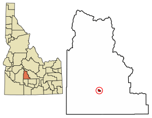
Location of Fairfield in Camas County, Idaho.
|
|
| Country | United States |
| State | Idaho |
| County | Camas |
| Area | |
| • Total | 0.88 sq mi (2.27 km2) |
| • Land | 0.88 sq mi (2.27 km2) |
| • Water | 0.00 sq mi (0.00 km2) |
| Elevation | 5,072 ft (1,546 m) |
| Population | |
| • Total | 416 |
| • Density | 450.91/sq mi (174.07/km2) |
| Time zone | UTC-7 (Mountain (MST)) |
| • Summer (DST) | UTC-6 (MDT) |
| ZIP codes |
83322, 83327
|
| Area code(s) | 208 |
| FIPS code | 16-26290 |
| GNIS feature ID | 2410475 |
Fairfield is a small city in Idaho, USA. It's the main town in Camas County. Fairfield is also the only city in the county.
In 2010, about 416 people lived there. This was almost half of all the people living in the whole county.
Contents
Fairfield's Location and Land
Fairfield is a small town. It covers an area of about 0.88 square miles (2.27 square kilometers). All of this area is land. There are no large bodies of water within the city limits.
Fairfield's Climate
Fairfield has a special kind of climate called a "warm-summer mediterranean continental climate". This means it has warm summers and cold winters.
The hottest temperature ever recorded in Fairfield was 101°F (38°C). This happened on July 12–14, 2002, and again on August 9, 2012. The coldest temperature ever recorded was a very chilly -42°F (-41°C) on January 19, 1984.
| Climate data for Fairfield, Idaho, 1991–2020 normals, extremes 1948–2020 | |||||||||||||
|---|---|---|---|---|---|---|---|---|---|---|---|---|---|
| Month | Jan | Feb | Mar | Apr | May | Jun | Jul | Aug | Sep | Oct | Nov | Dec | Year |
| Record high °F (°C) | 48 (9) |
63 (17) |
70 (21) |
83 (28) |
94 (34) |
99 (37) |
101 (38) |
101 (38) |
96 (36) |
87 (31) |
69 (21) |
58 (14) |
101 (38) |
| Mean maximum °F (°C) | 40.5 (4.7) |
44.6 (7.0) |
56.6 (13.7) |
72.8 (22.7) |
82.1 (27.8) |
89.3 (31.8) |
95.2 (35.1) |
94.5 (34.7) |
87.9 (31.1) |
76.9 (24.9) |
60.0 (15.6) |
42.6 (5.9) |
96.0 (35.6) |
| Mean daily maximum °F (°C) | 27.3 (−2.6) |
31.3 (−0.4) |
40.7 (4.8) |
53.8 (12.1) |
64.5 (18.1) |
73.0 (22.8) |
84.0 (28.9) |
82.8 (28.2) |
73.8 (23.2) |
59.0 (15.0) |
41.7 (5.4) |
28.0 (−2.2) |
55.0 (12.8) |
| Daily mean °F (°C) | 18.3 (−7.6) |
21.5 (−5.8) |
30.7 (−0.7) |
42.0 (5.6) |
51.3 (10.7) |
58.2 (14.6) |
67.0 (19.4) |
65.5 (18.6) |
56.7 (13.7) |
44.5 (6.9) |
31.0 (−0.6) |
19.0 (−7.2) |
42.1 (5.6) |
| Mean daily minimum °F (°C) | 9.2 (−12.7) |
11.7 (−11.3) |
20.6 (−6.3) |
30.1 (−1.1) |
38.1 (3.4) |
43.3 (6.3) |
50.1 (10.1) |
48.3 (9.1) |
39.5 (4.2) |
30.1 (−1.1) |
20.3 (−6.5) |
10.0 (−12.2) |
29.3 (−1.5) |
| Mean minimum °F (°C) | −18.6 (−28.1) |
−14.8 (−26.0) |
0.5 (−17.5) |
14.9 (−9.5) |
23.1 (−4.9) |
28.9 (−1.7) |
35.9 (2.2) |
32.9 (0.5) |
23.6 (−4.7) |
14.2 (−9.9) |
−4.5 (−20.3) |
−14.5 (−25.8) |
−23.5 (−30.8) |
| Record low °F (°C) | −42 (−41) |
−38 (−39) |
−24 (−31) |
−3 (−19) |
15 (−9) |
19 (−7) |
26 (−3) |
23 (−5) |
11 (−12) |
−16 (−27) |
−21 (−29) |
−40 (−40) |
−42 (−41) |
| Average precipitation inches (mm) | 2.11 (54) |
1.50 (38) |
1.61 (41) |
1.11 (28) |
1.60 (41) |
0.85 (22) |
0.38 (9.7) |
0.35 (8.9) |
0.70 (18) |
0.97 (25) |
1.39 (35) |
1.98 (50) |
14.55 (370.6) |
| Average snowfall inches (cm) | 11.6 (29) |
6.9 (18) |
2.4 (6.1) |
1.1 (2.8) |
0.1 (0.25) |
0.0 (0.0) |
0.0 (0.0) |
0.0 (0.0) |
0.0 (0.0) |
0.4 (1.0) |
5.7 (14) |
14.6 (37) |
39.2 (100) |
| Average precipitation days (≥ 0.01 in) | 4.8 | 4.9 | 4.8 | 4.7 | 5.4 | 3.6 | 2.3 | 1.6 | 2.2 | 3.3 | 5.8 | 4.8 | 48.2 |
| Average snowy days (≥ 0.1 in) | 3.4 | 2.3 | 0.9 | 0.5 | 0.0 | 0.0 | 0.0 | 0.0 | 0.0 | 0.3 | 2.0 | 4.0 | 13.4 |
| Source 1: NOAA | |||||||||||||
| Source 2: XMACIS2 (mean maxima/minima, snow/snow days, precip days 1981–2010) | |||||||||||||
People Living in Fairfield
| Historical population | |||
|---|---|---|---|
| Census | Pop. | %± | |
| 1920 | 280 | — | |
| 1930 | 306 | 9.3% | |
| 1940 | 511 | 67.0% | |
| 1950 | 502 | −1.8% | |
| 1960 | 474 | −5.6% | |
| 1970 | 336 | −29.1% | |
| 1980 | 404 | 20.2% | |
| 1990 | 371 | −8.2% | |
| 2000 | 395 | 6.5% | |
| 2010 | 416 | 5.3% | |
| 2019 (est.) | 395 | −5.0% | |
| U.S. Decennial Census | |||
Fairfield's Population in 2010
In 2010, a census counted 416 people living in Fairfield. These people lived in 176 homes. About 109 of these were families.
Most people in Fairfield were White (93%). A small number were Native American (1%), Asian (0.2%), or from other backgrounds. About 6.3% of the people were Hispanic or Latino.
Many homes (35.2%) had children under 18 living there. About 44.9% of homes had married couples. Some homes had a single female (6.8%) or male (10.2%) as the head of the house.
The average age of people in Fairfield was about 35 years old.
- 26.4% of residents were under 18.
- 5.6% were between 18 and 24.
- 29.6% were between 25 and 44.
- 27.4% were between 45 and 64.
- 11.1% were 65 or older.
There were slightly more males (51.9%) than females (48.1%) in Fairfield.
Getting Around Fairfield
Fairfield's main road is Soldier Road. You can reach Fairfield using U.S. Route 20. This highway connects Fairfield to Interstate 84 near Mountain Home to the west. To the east, it connects to State Highway 75.
Another road, State Highway 46, starts east of Fairfield. It goes south towards Gooding.
Schools in Fairfield
The public schools in Fairfield are run by the Camas County School District #121. The main school is Camas County High School. It is located on Soldier Road in the center of Fairfield.
Fun Things to Do in Fairfield
Fairfield is a great place for outdoor activities!
- The Soldier Mountains and Smoky Mountains are north of the town. These mountains are part of the Sawtooth National Forest.
- The Soldier Mountain ski area is about 12 miles (19 km) north of Fairfield. It opened in 1948.
- Fairfield is also famous for Snowkiting. This extreme sport involves using a kite to glide over snow. The snowkiting area is about 16 miles (26 km) west of the town.
- The Sun Valley ski resort is about 45 miles (70 km) northeast. You can get there by driving along State Highway 75.
- The western part of the Magic Reservoir is 10 miles (16 km) east of Fairfield.
- Silver Creek, a famous place for fly fishing, is about 30 miles (48 km) east of the town.
See also
 In Spanish: Fairfield (Idaho) para niños
 | Jewel Prestage |
 | Ella Baker |
 | Fannie Lou Hamer |


