Falkirk (council area) facts for kids
Quick facts for kids
Falkirk
Fawkirk
An Eaglais Bhreac |
||
|---|---|---|
 |
||
|
||
| Sovereign state | United Kingdom | |
| Country | Scotland | |
| Lieutenancy area | Stirling and Falkirk | |
| Admin HQ | Falkirk | |
| Government | ||
| • Body | Falkirk Council | |
| Area | ||
| • Total | 114.8 sq mi (297.4 km2) | |
| Area rank | Ranked 22nd | |
| Population
(2020)
|
||
| • Total | 160,340 | |
| • Rank | Ranked 11th | |
| • Density | 1,396.36/sq mi (539.14/km2) | |
| ONS code | S12000014 | |
| ISO 3166 code | GB-FAL | |
Falkirk is one of 32 council areas of Scotland. It's a special area that manages its own local services. This area was officially created on 1 April 1996. Before that, it was known as Falkirk District.
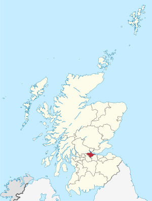
The Falkirk area shares its borders with North Lanarkshire, Stirling, and West Lothian. Across the Firth of Forth to the northeast, you'll find Clackmannanshire and Fife. The biggest town in the area is also called Falkirk. Other towns nearby include Bo'ness, Bonnybridge, Denny, Grangemouth, Larbert, Polmont, Shieldhill, Camelon, and Stenhousemuir.
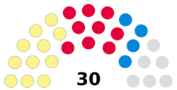
The local government, called the Falkirk Council, is currently led by the Scottish National Party (SNP). They won 12 seats in the 2022 Council Election. The main leader of the council is Councillor Cecil Meiklejohn. The provost, who is like a ceremonial head, is Robert Bissett. The deputy provost is David Balfour.
Contents
History of Falkirk's Government
The town of Falkirk became a special kind of town called a burgh in 1600. A burgh had its own town council to manage local affairs. This system lasted until 1975.
Changes in Local Government
In 1975, a new law changed how Scotland was governed locally. Old counties and burghs were replaced with larger "regions" and smaller "districts." Falkirk became one of three districts within the Central Region. This new Falkirk District was much bigger than the old Falkirk burgh. It included many smaller areas that were abolished at the same time.
The new Falkirk District, along with its neighbour Stirling, formed a new lieutenancy area called Stirling and Falkirk. A lieutenancy area is a place where the King's or Queen's representative, called a Lord-Lieutenant, carries out duties.
Modern Council Area
Local government changed again in 1996. The regions and districts created in 1975 were removed. Instead, new "unitary council areas" were formed. This meant that each area, like Falkirk, became responsible for all its local services. So, the Falkirk District became the Falkirk Council area we know today.
Towns and Villages in Falkirk
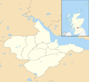
This map shows the main towns and villages in the Falkirk area.
Here are the largest towns and villages in Falkirk by population:
| Settlement | Population (2020) |
|---|---|
| Falkirk | 35590 |
| Grangemouth | 16120 |
| Bo'ness | 14840 |
| Larbert | 12180 |
| Stenhousemuir | 9620 |
| Denny | 8500 |
| Bonnybridge | 5200 |
| Polmont | 5040 |
| Brightons | 4270 |
| Maddiston | 3910 |
How Falkirk is Governed
The Falkirk Council is in charge of local services for the area. This includes things like schools, roads, and waste collection.
| Falkirk | |
|---|---|
 |
|
| Leadership | |
|
Kenneth Lawrie
Since August 2018 |
|
| Structure | |
| Seats | 30 councillors |
 |
|
|
Political groups
|
|
| Elections | |
| Single transferable vote | |
|
Last election
|
5 May 2022 |
|
Next election
|
6 May 2027 |
| Meeting place | |
| Falkirk | |
Council Leaders
The council has a leader who guides its work. Here are the leaders since 2001:
| Councillor | Party | From | To | |
|---|---|---|---|---|
| David Alexander | SNP | Feb 2001 | May 2007 | |
| Linda Gow | Labour | 18 May 2007 | Jan 2010 | |
| Craig Martin | Labour | 28 Jan 2010 | 4 May 2017 | |
| Cecil Meiklejohn | SNP | 25 May 2017 | ||
Where the Council Meets
From 1975, the council met at the Municipal Buildings in Falkirk. This building was opened in 1966. It also had a courthouse and a town hall.
The council decided in 2020 that the 1966 building was too old and expensive to fix. They moved out, and the building is now being taken down. The council's offices are currently in different buildings around the area. They are still planning for a new main office.
Council Elections
Elections for the Falkirk Council happen every five years. People vote using a system called single transferable vote. This system helps make sure that different groups get a fair number of seats.
Here are the results of past elections:
| Year | Seats | SNP | Labour | Conservative | Independent / Other | Notes |
|---|---|---|---|---|---|---|
| 1995 | 36 | 8 | 23 | 2 | 3 | |
| 1999 | 32 | 9 | 15 | 2 | 6 | New ward boundaries. |
| 2003 | 32 | 9 | 14 | 2 | 7 | |
| 2007 | 32 | 13 | 14 | 2 | 3 | New ward boundaries. |
| 2012 | 32 | 13 | 14 | 2 | 3 | |
| 2017 | 30 | 12 | 9 | 7 | 2 | New ward boundaries. |
| 2022 | 30 | 12 | 9 | 5 | 4 | |
Council Wards
For elections, the Falkirk area is split into smaller sections called "wards." Each ward chooses three or four councillors to represent them. This system helps make sure that people from different parts of the area have a voice.
Here are the wards in Falkirk:
Local Communities
The Falkirk area is divided into 23 smaller "community council areas." These are local groups that help represent the views of people in their specific neighbourhood. As of 2023, eleven of these areas have active community councils (marked with an asterisk).
- Airth Parish*
- Avonbridge and Standburn
- Banknock, Haggs and Longcroft*
- Blackness*
- Bonnybridge
- Bo'ness*
- Brightons*
- Camelon, Bantaskine and Tamfourhill*
- Carron and Carronshore
- Denny and District*
- Falkirk Central
- Falkirk South
- Grahamston, Middlefield and Westfield
- Grangemouth*
- Langlees, Bainsford and New Carron
- Larbert, Stenhousemuir and Torwood
- Lower Braes
- Maddiston
- Polmont*
- Reddingmuirhead and Wallacestone*
- Shieldhill and California
- Slamannan and Limerigg*
- Whitecross


