
Farallones de Cali facts for kids
Quick facts for kids Farallones de Cali |
|
|---|---|

Farallones de Cali
Location in Colombia
|
|
| Highest point | |
| Elevation | 4,050 m (13,290 ft) |
| Geography | |
| Country | Colombia |
| PNN Farallones de Cali | |
|---|---|
|
IUCN Category II (National Park)
|
|

Pico de Loro (Parrot Peak)
|
|
| Nearest city | Cali, Colombia |
| Area | 150,000 ha (580 sq mi) |
| Established | 1968 |
| Governing body | SINAP |
Farallones de Cali is a group of tall mountains in the West Andes of Colombia. They are located just west of the big city of Cali. These mountains are super important because many rivers start here. These rivers provide water and electricity for Cali.
The PNN Farallones de Cali is a huge national park that covers 150,000 ha (580 sq mi) of these mountains. It also includes a large part of the Pacific Ocean side. This area is famous for having a very high number of different plants and animals, which is called biodiversity. The temperature changes a lot here. It can be 25 °C (77 °F) in the warm, tropical lowlands. But it gets as cold as 5 °C (41 °F) in the high, grassy areas called páramo. Inside this park, you'll find places like Pichinde, Andes, and Leonera. There are also two small villages named Penas Blancas and Lomas de la Cajita.
Contents
Climate and Landscape of Farallones
The Farallones de Cali get a lot of rain every year. The Pacific side receives about 6,000 mm (240 in) of rain. The mountain areas get around 2,500 mm (98 in). This means plants always have enough water to grow all year long.
The park's landscape has very high, rocky peaks. The tallest peak reaches 4,050 m (13,290 ft) into the sky. These peaks are called Los Farallones, which means the cliffs. This is where the mountains and the national park get their name. On the eastern side, the mountains meet the flat Cauca Valley and the city of Cali. On the western side, many river canyons wind their way down to the Pacific Ocean. You can easily see the Farallones from the city of Cali.
Rivers Flowing from the Farallones
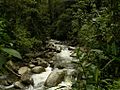
Many important rivers start in the Farallones de Cali. On the eastern side, these rivers flow towards the Cauca River. From north to south, they include the Cali, Pichindé, Cañaveralejo, Melendez, Lilí, Pance, and Jamundí rivers.
On the western side, several rivers flow into the Pacific Ocean. The main ones are the Dagua and Anchicayá rivers. There is even a hydroelectric dam on the Anchicayá River that helps make electricity.
Farallones de Cali National Park
The PNN Farallones de Cali is the biggest national park in the Valle del Cauca Department. It was created in 1968 to protect this special area. The park is a popular spot for hiking and birdwatching. You can get to the park from Cali in a couple of ways. One way is through the Pance River area in the south. Another way is from the north, through Peñas Blancas or the Pichindé River valley. To reach the Anchicayá River area, you can go through the town of El Queremal. The lowest part of the park is only 200 m (660 ft) above sea level, in the Pacific lowlands.
Different Nature Zones (Ecosystems)
Because the mountains are so tall and the Pacific Ocean is so close, the park has many different types of nature zones, or ecosystems. These include hot lowland jungles, misty mountain cloud forests, and cold, high páramos.
- Tropical Wet to Humid Forest is found at lower elevations, between 200 m (660 ft) and 1,000 m (3,300 ft). This forest has very tall rain forest trees. Their tops, called the canopy, can reach up to 40 m (130 ft) high. This area is on the western side of the West Andes. It is part of the important Chocó Biogeographic Region. A key area for many different species is around the upper Anchicayá River watershed.
- Subtropical Cloud Forest is located higher up, between 1,200 m (3,900 ft) and 2,000 m (6,600 ft). This cloud forest is often covered in fog. Inside, it's very mossy with many plants called epiphytes growing on trees. This ecosystem is also known as Subandean Forest.
- Montane Forest is found even higher, between 2,000 m (6,600 ft) and 3,500 m (11,500 ft). This high mountain forest has thick plants. The tree canopy can reach up to 20 m (66 ft). As you go higher, the trees generally get shorter. This ecosystem is also called Andean Forest.
- Páramo is the highest zone, above the tree line, at over 3,500 m (11,500 ft). This páramo is special because it's separated from other páramos. It doesn't have the typical Espeletia plants found in other Colombian páramos.
Sadly, these amazing ecosystems face some dangers. These include cutting down trees for wood, illegal mining, farming, too much tourism, forest fires, hunting, and building new roads.
Animals of Farallones de Cali
Birds
The Farallones de Cali is a paradise for birds! It is home to more than 300 different kinds of birds. Some of these birds are found only here, like the multicolored tanager (Chlorochrysa nitidissima), crested ant-tanager (Habia cristata), and chestnut wood-quail (Odontophorus hyperythrus). You can also see Andean cock-of-the-rock (Rupicola peruvianus) birds performing their special dances. The most famous place to see them is in the Peñas Blancas area of the Pichindé River valley. Birdwatchers from all over the world know about the amazing variety of birds in the Anchicayá area.
Mammals
Many different mammals live in the park's various habitats. These include bats, squirrels, raccoons and their relatives, anteaters, several types of felids (wild cats), foxes, and marsupials. The spectacled bear (Tremarctos ornatus) lives on the western side of the mountains. This bear is a vulnerable species, meaning it needs protection.
Five types of primates (monkeys) also live in the park:
- White-headed capuchin - known as Mono manicero
- Red howler monkey
- Mantled howler monkey
- Gray-bellied night monkey (Aotus lemurinus): This monkey is vulnerable and called Marteja in Colombia.
- Colombian spider monkey (Ateles fusciceps rufiventris): This monkey is critically endangered, meaning it's in great danger of disappearing. It's called Marimonda in Colombia.
Amphibians
The park is also home to interesting amphibians:
- Bufo hypomelas - a type of toad called Sapo Mamboré
- Dendrobates lehmanni - the Red-banded poison frog, also known as Oophaga lehmanni
Plants of Farallones de Cali
On the western side, between 200 and 1,000 m high, there is a dry tropical forest. Here, trees can grow up to 40 m tall. Beneath these tall trees, you'll find tall grasses. There are also many different kinds of lianas and woody vines. On top of tree branches, numerous epiphytes grow. Some unique plants found here include cargadera, guabo sleeper, wild cacao, and sirop. Among the palms in this forest, you can find taparín, barrigona or pambil, and cumbi.
In the temperate zone, between 1,000 and 2,000 meters, you'll see trees like oak, sapote bush, media cara, encenillo, azuceno, white yarumo, and balsa.
The cold zone, between 2,400 and 3,600 meters, has many epiphytes. Above 3,600 meters, you reach the moorlands, where frailejones are the most common plant. Among the plants found only in the Farallones, there is a special wild violet.
Cool Places to Visit in Farallones
El Topacio
This spot is very close to a town called Pance. If you want to camp here overnight in a tent, you need a permit from the CVC (Regional Autonomous Corporation of the Valle del Cauca). The parking area is small. It has basic services, including a radio station at the ranger's house. From El Topacio, you can visit two beautiful waterfalls.
Pico de Loro (Parrot Peak)
The trail to Pico de Loro starts at El Topacio. Climbing to the top can take several hours, depending on how fast you walk. From the peak, which is 2,832 m (9,291 ft) high, you can see part of Cali city, the Cauca River, and its valley. There isn't a camping spot right at the top, but there are several springs on the way up.
Punta Pance
At 4,020 m (13,190 ft), Punta Pance is a challenging trip that can take one or two days. It's best for experienced hikers. From the top, you get an amazing view of the whole region. On clear days, you might see the Pacific Ocean and the port of Buenaventura to the west. To the east, you can see Cali, the Cauca River and its valley, and sometimes even the Cordillera Central with the Nevado del Huila volcano. To the southwest, you can spot Cerro Naya, and to the northwest, Cerro Calima.
You can camp at a place called "Balconies." It has a spring and enough space for 5-10 tents. Another option is to climb a bit higher and camp near the Punta Pance Lagoons.
Alto del Buey
This peak is 3,480 m (11,420 ft) high. You start your climb from the entrance at Peñas Blancas. It can take a full day on a good path. From the top, you can see parts of Buenaventura and Cali. The camping area is small, fitting only 2 or 3 tents.
Gaps of Alto del Buey
This is a tough path down from the top of Alto del Buey. Sometimes it's necessary if there's no water at the top. From above, the gaps look much bigger than they are. Always remember to go with a guide!
Valley de los Osos (Valley of the Bears)
You can reach this valley from the northern edge of Punta Pance, heading towards the western side. There's a river here, and you might notice that humans have changed the landscape a bit. It's located between Punta Pance and the Cajambres Massif.
Macizo Cajambres
This area is west of Punta Pance, after you pass the Valley of the Bears. You might see some erosion (where the land has worn away) on its eastern slopes.
Peñas Blancas
This is another important area, especially known for birdwatching.
Images for kids
-
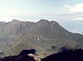
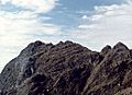
Macizo Cajambres & Valle de los Osos
-
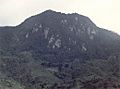
Peñas Blancas
-
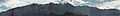
Panorama
-
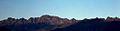
Panorama
-
Punta Pance from the northeast
-
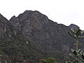
Punta Pance from the southeast
-
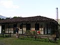
Ranger Home - El Topacio
-
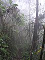
Rainforest
-
Anchicayá River


See also
 In Spanish: Farallones de Cali para niños
- List of national parks of Colombia
- Andean Region, Colombia
- Pacific Region, Colombia
- List of mountains in the Andes
- List of Ultras of South America
- Pico Loro
