Fayette County, Kentucky facts for kids
Quick facts for kids
Fayette County
|
||
|---|---|---|
|
Consolidated city-county
|
||
| Lexington-Fayette Urban County | ||

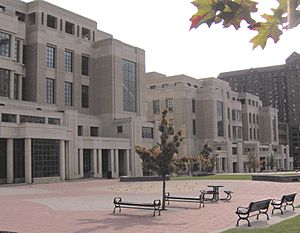
Robert F. Stephens Courthouse Complex in Lexington
|
||
|
||

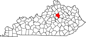
Location within the U.S. state of Kentucky
|
||
 Kentucky's location within the U.S. |
||
| Country | ||
| State | ||
| Founded | 1780 | |
| Named for | Gilbert du Motier, Marquis de Lafayette | |
| Seat | Lexington | |
| Largest city | Lexington | |
| Area | ||
| • Total | 286 sq mi (740 km2) | |
| • Land | 284 sq mi (740 km2) | |
| • Water | 1.9 sq mi (5 km2) 0.7%% | |
| Population
(2020)
|
||
| • Total | 322,570 | |
| • Estimate
(2023)
|
320,154 |
|
| • Density | 1,127.9/sq mi (435.5/km2) | |
| Time zone | UTC−5 (Eastern) | |
| • Summer (DST) | UTC−4 (EDT) | |
| Congressional district | 6th | |
Fayette County is a county located in the central part of the U.S. state of Kentucky. It is special because its government is combined with the city of Lexington. This means they share one big government for both the county and the city. In 2020, about 322,570 people lived here, making it the second-largest county in Kentucky. Fayette County is also part of the larger Lexington area.
Contents
History of Fayette County

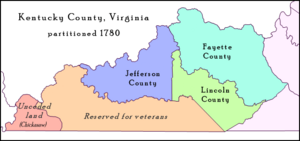
Fayette County was created in June 1780 by the Virginia General Assembly. Back then, it was part of Virginia. The assembly split a large area called Kentucky County into three new counties: Fayette, Jefferson, and Lincoln.
These counties, along with others formed later, separated from Virginia in 1792. They then became the new Commonwealth of Kentucky.
When it was first formed, Fayette County was much larger. It included land that is now 37 different counties and parts of 7 others! But by 1799, its size was reduced to what it is today.
The county is named after the Marquis de LaFayette. He was a French military officer who came to the United States to help the American colonies fight for their freedom during the American Revolutionary War.
On January 1, 1974, Fayette County and its main city, Lexington, joined their governments. This created a consolidated city-county. It is now run by the Lexington-Fayette Urban County Government.
Geography of Fayette County
Fayette County covers about 286 square miles. Most of this area, about 284 square miles, is land. The rest, about 1.9 square miles, is water.
Main Roads
- Interstate 75
- Interstate 64
- U.S. Route 25
- U.S. Route 27
- U.S. Route 60
- U.S. Route 68
- U.S. Route 421
- Kentucky Route 4, also known as New Circle Road
Neighboring Counties
- Scott County (north)
- Bourbon County (northeast)
- Clark County (east)
- Madison County (south)
- Jessamine County (south)
- Woodford County (west)
People of Fayette County
| Historical population | |||
|---|---|---|---|
| Census | Pop. | %± | |
| 1790 | 18,410 | — | |
| 1800 | 14,028 | −23.8% | |
| 1810 | 21,370 | 52.3% | |
| 1820 | 23,250 | 8.8% | |
| 1830 | 25,098 | 7.9% | |
| 1840 | 22,194 | −11.6% | |
| 1850 | 22,735 | 2.4% | |
| 1860 | 22,599 | −0.6% | |
| 1870 | 26,656 | 18.0% | |
| 1880 | 29,023 | 8.9% | |
| 1890 | 35,698 | 23.0% | |
| 1900 | 42,071 | 17.9% | |
| 1910 | 47,715 | 13.4% | |
| 1920 | 54,664 | 14.6% | |
| 1930 | 68,543 | 25.4% | |
| 1940 | 78,899 | 15.1% | |
| 1950 | 100,746 | 27.7% | |
| 1960 | 131,906 | 30.9% | |
| 1970 | 174,323 | 32.2% | |
| 1980 | 204,165 | 17.1% | |
| 1990 | 225,366 | 10.4% | |
| 2000 | 260,512 | 15.6% | |
| 2010 | 295,803 | 13.5% | |
| 2020 | 322,570 | 9.0% | |
| 2023 (est.) | 320,154 | 8.2% | |
| U.S. Decennial Census 1790-1960 1900-1990 1990-2000 2010-2020 |
|||
In 2010, there were about 295,803 people living in Fayette County. There were 123,043 households, which are groups of people living together.
Most people in the county were White (75.7%). About 14.5% were Black or African American. Other groups included Asian (3.2%), Native American (0.3%), and Pacific Islander (0.1%). About 6.9% of the population was Hispanic or Latino.
The average age of people in the county was 33.7 years old. About 21.2% of the population was under 18 years old.
Education in Fayette County
Schools in Fayette County are managed by Fayette County Public Schools.
Public High Schools
- Henry Clay High School
- Paul Laurence Dunbar High School
- Frederick Douglass High School
- Bryan Station High School
- Lafayette High School
- Tates Creek High School
- STEAM Academy
Private Middle and Elementary Schools
- The Lexington School
- Sayre School
- Lexington Christian Academy
- Christ the King School
- Mary Queen of the Holy Rosary School
- Saints Peter and Paul School
- Seton Catholic School
- Blue Grass Baptist School
- Redwood Cooperative School
Private High Schools
- Lexington Catholic High School
- Lexington Christian Academy
- Sayre School
- Trinity Christian Academy
- Blue Grass Baptist School
Colleges and Universities
- Bluegrass Community and Technical College
- Indiana Wesleyan University (Lexington campus)
- ITT Technical Institute
- Lexington Theological Seminary
- Midway College (Lexington campus)
- National College of Business & Technology
- Spencerian College
- Sullivan University
- Transylvania University
- University of Kentucky
Communities in Fayette County
City
Unincorporated Communities
These are areas that are not officially part of a city but are still recognized communities.
- Andover
- Athens
- Clays Ferry
- Colby (partly in Clark County)
- Little Texas
- South Elkhorn
- Spears (partly in Jessamine County)
- Todds Station
Historically Black Hamlets
These are small, historic communities that were traditionally settled by Black families.
- Bracktown
- Cadentown
- Jimtown
- Smithtown
- Little Georgetown
- Pralltown
See also
 In Spanish: Condado de Fayette (Kentucky) para niños
 | Aaron Henry |
 | T. R. M. Howard |
 | Jesse Jackson |


