Ferdinand, Idaho facts for kids
Quick facts for kids
Ferdinand, Idaho
|
|
|---|---|

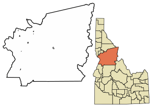
Location of Ferdinand in Idaho County, Idaho.
|
|
| Country | United States |
| State | Idaho |
| County | Idaho |
| Area | |
| • Total | 0.17 sq mi (0.45 km2) |
| • Land | 0.17 sq mi (0.45 km2) |
| • Water | 0.00 sq mi (0.00 km2) |
| Elevation | 3,727 ft (1,136 m) |
| Population
(2010)
|
|
| • Total | 159 |
| • Density | 925.71/sq mi (358.13/km2) |
| Time zone | UTC-8 (Pacific (PST)) |
| • Summer (DST) | UTC-7 (PDT) |
| ZIP code |
83526
|
| Area code(s) | 208 |
| FIPS code | 16-27460 |
| GNIS feature ID | 2410495 |
Ferdinand is a small city located in Idaho County, Idaho, in the United States. It is found at the southern edge of the Nez Perce Indian Reservation. The city was started in 1895 by F.M. Bieker, soon after the reservation land became open for new settlers. He named it after Ferdinand, Indiana, where his mother's family used to live. In 2010, about 159 people lived in Ferdinand.
| Historical population | |||
|---|---|---|---|
| Census | Pop. | %± | |
| 1920 | 255 | — | |
| 1930 | 196 | −23.1% | |
| 1940 | 223 | 13.8% | |
| 1950 | 206 | −7.6% | |
| 1960 | 176 | −14.6% | |
| 1970 | 157 | −10.8% | |
| 1980 | 144 | −8.3% | |
| 1990 | 135 | −6.2% | |
| 2000 | 145 | 7.4% | |
| 2010 | 159 | 9.7% | |
| 2019 (est.) | 162 | 1.9% | |
| U.S. Decennial Census | |||
Contents
Geography
Ferdinand is situated on a flat, open area known as the Camas Prairie.
According to the United States Census Bureau, the city covers a total area of about 0.45 square kilometers (0.17 square miles). All of this area is land, with no water within the city limits.
Transportation
Highways
![]() U.S. Route 95 is a major highway that passes near Ferdinand. It connects the city to Craigmont to the north and Cottonwood to the south.
U.S. Route 95 is a major highway that passes near Ferdinand. It connects the city to Craigmont to the north and Cottonwood to the south.
Before 1993, the highway used to go through the middle of Ferdinand. It would pass under railroad tracks and then follow a winding path down into Lawyers Creek Canyon. There, it went under a tall timber trestle, which is like a bridge made of wooden supports.
In 1993, the highway was changed to a straighter path. The new US-95 now goes around the east side of Ferdinand. It stays above the canyon and crosses Lawyers Creek on a long bridge that opened in 1991. This new route makes travel faster and safer.
Railroads
The Camas Prairie Railroad reached Ferdinand in 1909. This railway line branched off from the main line at Spalding and ended in Grangeville.
Since 1998, the ownership of this railway line has changed several times. Today, it is operated by the BG&CM Railroad. The line now ends in Cottonwood. Passenger trains stopped running on this line in 1955.
People of Ferdinand
2010 Census Information
In 2010, the city of Ferdinand had 159 people living there. These people made up 63 households, and 47 of these were families.
The population density was about 358 people per square kilometer (925 people per square mile). There were 67 housing units, which are homes or apartments, in the city.
Most of the people in Ferdinand were White (93.7%). There were also small numbers of Native American, Asian, and people from two or more races. About 3.8% of the population identified as Hispanic or Latino.
Of the 63 households:
- 38.1% had children under 18 years old living with them.
- 57.1% were married couples living together.
- 6.3% had a female head of household with no husband present.
- 11.1% had a male head of household with no wife present.
- 25.4% were non-family households, meaning people living alone or with roommates.
The average household had 2.52 people, and the average family had 2.87 people.
The median age in Ferdinand was 38.5 years old. This means half the people were younger than 38.5 and half were older.
- 27% of residents were under 18 years old.
- 5.8% were between 18 and 24 years old.
- 27% were between 25 and 44 years old.
- 27.7% were between 45 and 64 years old.
- 12.6% were 65 years old or older.
More males lived in Ferdinand than females, with 55.3% male and 44.7% female residents.
See also
 In Spanish: Ferdinand (Idaho) para niños
 | Delilah Pierce |
 | Gordon Parks |
 | Augusta Savage |
 | Charles Ethan Porter |

