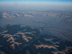
Fish River (Alaska) facts for kids
Quick facts for kids Fish River (Alaska) |
|
|---|---|

River basin east of Nome
|
|
|
Location of the mouth of the Fish River in Alaska
|
|
| Native name | Ikalikhvik |
| Country | United States |
| State | Alaska |
| Region | Nome Census Area |
| Physical characteristics | |
| Main source | Bendeleben Mountains 2,384 ft (727 m) 65°19′00″N 163°05′32″W / 65.31667°N 163.09222°W |
| River mouth | Golovnin Bay 35 miles (56 km) east of Solomon 0 ft (0 m) 64°55′10″N 163°21′00″W / 64.91944°N 163.35000°W |
| Length | 47 mi (76 km) |
The Fish River is an important waterway in Alaska, a state in the United States. Its name in the local Inupiaq language is Iġalugvik. This name means "fish" or "fish place". The river is about 47-mile-long (76 km).
It starts high up in the Bendeleben Mountains. From there, it flows south into Golovnin Lagoon. Finally, it empties into Golovnin Bay, which is part of Norton Sound and the larger Bering Sea. The area around the Fish River is famous for its placer gold deposits. The Niukluk River, a branch of the Fish River, has produced more gold than any other place in this region.
Contents
What's in a Name?
The name Ikalikhvik was first written down in 1838. This was by Aleksandr Filippovich Kashevarov, a Russian explorer. It meant "fish" or "fish place" in the Inuit language.
Later, in 1870, a person named Dall first used the name "Fish River." He wrote about how Golovnin Bay connects to a large lagoon. This lagoon then connects to the Fish River, which has a main branch called the Kavi-ava-zak. Today, the Kavi-ava-zak is known as the Niukluk River.
River's Journey and Surroundings
The Fish River is one of several rivers that start in the northern Bendeleben Mountains. You can get to this area from Nome by using a small airstrip at White Mountain.
The river's catchment area is huge, about 2,000 square miles (5,200 km2). This area is bordered by Golovnin Sound to the south. To the west is the Kruzgamepa River, and to the north are mountains. Many smaller streams flow into the Fish River. Most of these streams are similar in length and have about the same amount of water flowing through them.
The northwest part of the river basin has hills that rise to about 3,000 feet (910 m). Two streams begin here, rushing quickly through the hills. Then they reach flatter land where the river winds around and forms sandbars. All these streams join together before the river enters a flat area.
The Fish River then meets the Niukluk River. After this, it flows in many loops and forms the beginning of the delta for Golovnin Sound. This delta is a wide, flat area, about 5 to 6 miles (8 to 10 km) across. It reaches the base of White Mountain, which is a low mountain about 200 feet (61 m) high. White Mountain is mostly made of limestone.
The delta has two main channels, with smaller sloughs, marshes, and ponds in between. Both channels are deep enough for boats. The western channel is larger and good for river boats. The eastern channel is also good for lighter boats.
Rocks and Land Features
At the start of the Fish River, you can find granite rocks. There are also schist rocks mixed in. In some parts of the river valley, you can see cliffs made of slate. White, shiny marble has been found where two branches of the Fish River meet. This marble is found between areas of granite. The narrow gorge section of the river has both schist and limestone rock formations.
In the larger area of the Seaward Peninsula, schist and limestone formations are also common. These rocks are very old. In the White Mountain area of the Fish River Basin, a special type of limestone has been found. It contains fossils of ancient shells. These fossils are similar to others found in southeastern Alaska.
Amazing Wildlife
The Fish River is well-known for its many fish. This has led to many fishing camps being set up along its banks. Here are some of the fish you might find in the river:
- Chum salmon
- Silver salmon
- Pink salmon
- Chinook salmon
- Red salmon
- Burbot
- Northern pike
- Dolly Varden
- Arctic grayling
- Whitefish
You might also spot Bald eagles nesting where the Fish River meets the Niukluk River.
Gold and Silver Mining
The Fish River valley, especially its longest branch, the Niukluk, has produced a lot of gold. This area is called the Council district. People first found gold from the mouth of the river all the way up to the gorge. The river water was clear in the lower parts but became heavier with gold closer to the narrow parts of the valley. Here, limestone and schist rock layers cross the river. Gold deposits are found from the river's mouth up into the gorge. However, no gold was found in the higher, flat areas made of lava.
In the Council district, people started looking for placer gold in 1898. Mining became very active, and the amount of gold found was the second highest in the region, after Nome.
Silver was also found in the upper parts of the Fish River at a place called the Omalik Mine. A small amount of lead was also taken from this mine as early as 1881.
 | Kyle Baker |
 | Joseph Yoakum |
 | Laura Wheeler Waring |
 | Henry Ossawa Tanner |


