
Fisk, Missouri facts for kids
Quick facts for kids
Fisk, Missouri
|
|
|---|---|

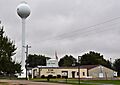
City Hall of Fisk, October 2014.
|
|
| Country | United States |
| State | Missouri |
| County | Butler |
| Area | |
| • Total | 0.33 sq mi (0.85 km2) |
| • Land | 0.32 sq mi (0.84 km2) |
| • Water | 0.01 sq mi (0.01 km2) |
| Elevation | 328 ft (100 m) |
| Population
(2020)
|
|
| • Total | 312 |
| • Density | 962.96/sq mi (372.15/km2) |
| Time zone | UTC-6 (Central (CST)) |
| • Summer (DST) | UTC-5 (CDT) |
| ZIP code |
63940
|
| Area code(s) | 573 |
| FIPS code | 29-24328 |
| GNIS feature ID | 2394768 |
Fisk is a small city in Butler County, located in the southeastern part of Missouri, United States. It sits right on the border between Butler and Stoddard Counties. The city is found along U.S. Route 60 and near the St. Francis River. In 2020, the population of Fisk was 312 people.
Fisk is also part of the larger Poplar Bluff Micropolitan Statistical Area.
Contents
History of Fisk
Fisk got its post office in 1899. The town was named after Samuel J. Fisk. He owned a sawmill in the area.
Geography of Fisk
Fisk is in the flat southeastern part of Missouri. It sits on the west side of the St. Francis River. The city is about halfway between Poplar Bluff and Dexter.
The United States Census Bureau says that Fisk covers a total area of about 0.33 square miles (0.85 square kilometers). Most of this area, about 0.32 square miles (0.84 square kilometers), is land. A very small part, about 0.01 square miles (0.01 square kilometers), is water.
Population Changes in Fisk
The number of people living in Fisk has changed over the years. Here's a quick look at the population from different census years:
- 1920: 466 people
- 1930: 387 people
- 1940: 386 people
- 1950: 542 people
- 1960: 498 people
- 1970: 503 people
- 1980: 450 people
- 1990: 422 people
- 2000: 363 people
- 2010: 342 people
- 2020: 312 people
Fisk in 2010
According to the census from 2010, there were 342 people living in Fisk. These people lived in 163 households, and 88 of these were families. The city had about 1,069 people per square mile (413 people per square kilometer).
Most of the people in Fisk were White (99.42%). A small number (0.58%) were from two or more races. About 0.29% of the population was Hispanic or Latino.
In the households, 25.8% had children under 18. About 36.8% were married couples living together. Some households had a female head without a husband (14.1%) or a male head without a wife (3.1%). Nearly half (46.0%) were not families. Many households (40.5%) had only one person living there. About 17.2% had someone aged 65 or older living alone.
The average household had 2.10 people. The average family had 2.80 people. The average age in the city was 46 years old. About 19.9% of residents were under 18. About 18.7% were 65 or older. The city had slightly more females (52.9%) than males (47.1%).
Climate in Fisk
Fisk has a climate with fairly high temperatures and rain spread out throughout the year. This type of weather is called a "Humid Subtropical Climate" (Cfa in the Köppen Climate Classification system).
| Climate data for Fisk, Missouri | |||||||||||||
|---|---|---|---|---|---|---|---|---|---|---|---|---|---|
| Month | Jan | Feb | Mar | Apr | May | Jun | Jul | Aug | Sep | Oct | Nov | Dec | Year |
| Mean daily maximum °C (°F) | 21 (70) |
7 (45) |
10 (50) |
16 (60) |
22 (71) |
26 (79) |
31 (88) |
33 (91) |
32 (90) |
29 (84) |
23 (73) |
15 (59) |
22 (72) |
| Mean daily minimum °C (°F) | −4 (25) |
−2 (29) |
3 (37) |
8 (47) |
13 (56) |
18 (64) |
20 (68) |
19 (66) |
15 (59) |
8 (47) |
2 (36) |
−2 (28) |
8 (47) |
| Average precipitation mm (inches) | 91 (3.6) |
79 (3.1) |
120 (4.7) |
120 (4.6) |
120 (4.7) |
100 (4) |
91 (3.6) |
89 (3.5) |
91 (3.6) |
84 (3.3) |
100 (4) |
99 (3.9) |
1,184 (46.6) |
| Average precipitation days | 8 | 7 | 9 | 10 | 10 | 8 | 7 | 7 | 7 | 7 | 8 | 8 | 96 |
| Source: Weatherbase | |||||||||||||
Education in Fisk
The Twin Rivers R-X School District serves the community of Fisk. This district runs the Fisk School. It also operates Twin Rivers High School in Broseley.
Fisk also has a public library for its residents, called the Fisk Community Library.
Images for kids
-
City Hall of Fisk, October 2014.
See also
 In Spanish: Fisk (Misuri) para niños
