Fordbridge facts for kids
Quick facts for kids Fordbridge |
|
|---|---|
| Town | |
 |
|
| Population | 8,479 (2011) |
| Civil parish |
|
| Metropolitan borough |
|
| Shire county | |
| Metropolitan county | |
| Region | |
| Country | England |
| Sovereign state | United Kingdom |
| Post town | BIRMINGHAM |
| Postcode district | B37 |
| Dialling code | 0121 |
| Police | West Midlands |
| Fire | West Midlands |
| Ambulance | West Midlands |
| EU Parliament | West Midlands |
| UK Parliament |
|
Fordbridge is a town located in the West Midlands, England. It is part of the Metropolitan Borough of Solihull. In 2011, about 8,479 people lived here.
Fordbridge is also known as a civil parish, which is a local area with its own council. Historically, it was part of the county of Warwickshire. The town is included in the Kingshurst & Fordbridge election area.
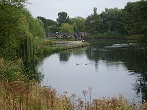
To the west, Fordbridge borders the village of Kingshurst near Cooks Lane. A large part of the town's eastern side is next to the city of Birmingham. The River Cole forms the border between Fordbridge and its nearby town, Chelmsley Wood, to the south and west.
What's in a Name? The Story of Fordbridge
Have you ever wondered how places get their names? Fordbridge got its name from a special crossing over the River Cole. On old maps from the 1800s, this spot on Cooks Lane was called "Ford Bridge."
This name tells us that the crossing was first a ford. A ford is a shallow place in a river where people and animals can walk or drive across. Later, a bridge was built there. So, the name "Fordbridge" combines both the old way of crossing and the new one!
Getting Around: Transport in Fordbridge
If you need to travel by train, the closest railway station to Fordbridge is Marston Green. It connects the town to other places by rail.
 | Emma Amos |
 | Edward Mitchell Bannister |
 | Larry D. Alexander |
 | Ernie Barnes |


