Fordsdale, Queensland facts for kids
Quick facts for kids FordsdaleQueensland |
|||||||||||||||
|---|---|---|---|---|---|---|---|---|---|---|---|---|---|---|---|

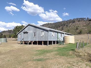
School of Arts hall, 2014
|
|||||||||||||||
| Population | 50 (2021 census) | ||||||||||||||
| • Density | 0.77/km2 (2.0/sq mi) | ||||||||||||||
| Postcode(s) | 4343 | ||||||||||||||
| Area | 64.7 km2 (25.0 sq mi) | ||||||||||||||
| Time zone | AEST (UTC+10:00) | ||||||||||||||
| Location | |||||||||||||||
| LGA(s) | Lockyer Valley Region | ||||||||||||||
| State electorate(s) | Lockyer | ||||||||||||||
| Federal Division(s) | Wright | ||||||||||||||
|
|||||||||||||||
Fordsdale is a small, quiet place in the countryside of Queensland, Australia. It's part of the Lockyer Valley Region. In 2021, only about 50 people lived there. It's a rural area, meaning it's mostly farmland and natural bushland.
Contents
Exploring Fordsdale's Geography
Fordsdale is a place with rugged land. This means it has hills and uneven ground. The lower areas near creeks are used for farming. The steeper, higher parts are still covered in natural plants and trees.
Two creeks, Silky Oak Creek and Ma Ma Creek, meet up in Fordsdale. Ma Ma Creek then flows into Lockyer Creek. On the western side of Fordsdale, you can find Dwyers Scrub Regional Park. This park helps protect the natural environment. The main road that goes through Fordsdale is the Gatton–Clifton Road.
Fordsdale's Past: A Look at History
Fordsdale got its name from William Thomas Ford. He was a farmer who lived in nearby Mount Whitestone. From 1896, he was in charge of delivering mail from Grantham to Mount Whitestone.
Early Schools in Fordsdale
Education has a long history in Fordsdale.
- The first school, called Ma Ma Creek Upper Provisional School, opened on July 8, 1895. Mr. H. C. Tronc was its first headmaster.
- In 1906, the school's name changed to Fordsdale Provisional School.
- On January 1, 1909, it became Fordsdale State School.
- The school closed for a short time in April 1929 but reopened in 1931. This first school was located at 1902 Gatton Clifton Road.
The School of Arts Hall
The Fordsdale School of Arts Hall was officially opened on May 27, 1932. Councillor Byrne, who was the chairman of the Tarampa Shire Council, opened it. These halls were important community places where people could gather for events and learning.
A New School Building
The school closed again in 1933. But it reopened in 1937 with Miss E. G. M. Allen as the new head teacher. For a while, classes were held in the School of Arts Hall because it was easier for everyone to get to. Because many students attended, it was decided to build a brand new school. Mr. W. Bynon kindly donated land near the hall for the new building.
The new Fordsdale State School was officially opened on Saturday, June 3, 1939. A special guest, Ted Maher, who was the Leader of the Opposition at the time, helped open it. This school continued to operate until it closed permanently in 1967. It was located at about 2085 Gatton Clifton Road.
Who Lives in Fordsdale?
The number of people living in Fordsdale is quite small.
- In 2011, Fordsdale and the areas around it had a population of 211 people.
- By 2016, the population of Fordsdale itself was 52 people.
- In the most recent count in 2021, the population was 50 people.
Learning Near Fordsdale
There are no schools directly in Fordsdale today.
- For younger students, the closest primary school is Mount Whitestone State School. It's located in the nearby area of Mount Whitestone.
- For older students, the nearest high schools are Lockyer District State High School in Gatton and Centenary Heights State High School in Centenary Heights, which is part of Toowoomba.
Community Places in Fordsdale
The Fordsdale School of Arts Hall is still an important community building. You can find it at 2085 Gatton Clifton Road. It serves as a place for local events and gatherings.
 | John T. Biggers |
 | Thomas Blackshear |
 | Mark Bradford |
 | Beverly Buchanan |


