
West Haldon, Queensland facts for kids
Quick facts for kids West HaldonQueensland |
|||||||||||||||
|---|---|---|---|---|---|---|---|---|---|---|---|---|---|---|---|

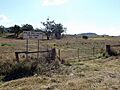
View across West Haldon, 2022
|
|||||||||||||||

West Haldon
Location in Queensland
|
|||||||||||||||
| Population | 63 (2021 census) | ||||||||||||||
| • Density | 0.660/km2 (1.71/sq mi) | ||||||||||||||
| Postcode(s) | 4359 | ||||||||||||||
| Area | 95.4 km2 (36.8 sq mi) | ||||||||||||||
| Time zone | AEST (UTC+10:00) | ||||||||||||||
| Location | |||||||||||||||
| LGA(s) |
|
||||||||||||||
| State electorate(s) |
|
||||||||||||||
| Federal Division(s) | |||||||||||||||
|
|||||||||||||||
West Haldon is a small area, or 'locality', in Queensland, Australia. It's located across two different regions: the Toowoomba Region and the Lockyer Valley Region. In 2021, only 63 people lived here, making it a very quiet place!
Contents
Exploring West Haldon's Landscape
West Haldon is surrounded by beautiful nature. To its south and southwest, you'll find the Main Range, which is part of Australia's huge Great Dividing Range.
Mountains and Hills
The land in West Haldon changes a lot, from lower areas that are about 230 meters (750 feet) high to taller spots reaching 790 meters (2,590 feet). The eastern parts are generally lower, and the land gets higher as you move towards the Great Dividing Range.
There are three special peaks in West Haldon:
- Tipsy Point is in the northwest and is about 622 meters (2,041 feet) tall.
- Townley Point is also in the northwest, reaching about 677 meters (2,221 feet) high.
- Paradise Mountain is in the northeast and is the tallest at about 702 meters (2,303 feet).
Land Use and Roads
Most of the land in West Haldon is used for grazing. This means animals like cattle or sheep eat the natural plants growing there. The main road, Gatton–Clifton Road, goes through West Haldon. It enters from the north (near Fordsdale) and leaves towards the south (near Hirstglen).
A Look Back: West Haldon's History
West Haldon has a simple but interesting history, mainly focused on its school and a local sports club.
The First School in West Haldon
Back in March 1892, the people living in West Haldon decided they needed a school for their children. A kind person named Mr. Young offered five acres of his land for the school. Others helped raise money to build it.
The West Haldon Provisional School first opened its doors on April 7, 1896. It started with 17 students, and Bernard MacGinley was the first head teacher. On January 1, 1909, it became the West Haldon State School. However, it closed on September 18, 1949, because not enough students were attending anymore. The old school was located at the corner of Gatton Clifton Road and MacGinley Road.
West Haldon Polo Club
For many years, West Haldon was home to a polo club! The West Haldon Polo Club started in 1913. Polo is a sport played on horseback, where players use mallets to hit a ball. The club was active for a long time, until 1969. Its old ground was located on Gatton-Clifton Road.
Who Lives in West Haldon?
West Haldon is a small community. In 2016, there were 62 people living there. By 2021, the population had grown slightly to 63 people.
Learning Opportunities Near West Haldon
There are no schools directly in West Haldon itself. However, students living here can attend schools in nearby towns and areas.
Primary Schools Nearby
For younger students, the closest primary schools are:
- Mount Whitestone State School, to the north.
- Mount Sylvia State School, to the northeast.
- Pilton State School, to the south.
- Emu Creek State School, to the west.
- Ramsay State School, to the northwest.
Secondary Schools Nearby
For older students, the closest high schools are:
- Lockyer District State High School in Gatton, to the northeast.
- Clifton State High School in Clifton, to the southwest.
- Centenary Heights State High School in Centenary Heights, to the northwest.
Images for kids
-
Former polo ground, 2014

