
Forestdale, London facts for kids
Quick facts for kids Forestdale |
|
|---|---|
 Forestdale welcome sign |
|

Forestdale
|
|
| OS grid reference | TQ3762 |
| London borough | |
| Ceremonial county | Greater London |
| Region | |
| Country | England |
| Sovereign state | United Kingdom |
| Post town | CROYDON |
| Postcode district | CR0 |
| Dialling code | 020 |
| Police | Metropolitan |
| Fire | London |
| Ambulance | London |
| EU Parliament | London |
| UK Parliament |
|
| London Assembly |
|
Forestdale is a friendly neighbourhood in southeast London, England. It's part of the London Borough of Croydon. Sometimes, people think of it as part of Addington, which is a nearby area. Forestdale is surrounded by other places like Selsdon and New Addington. It's a great place to live with lots of homes.
Contents
Exploring Forestdale's Surroundings
Forestdale has lovely green spaces. You can find public grassy areas and a nature reserve. This reserve offers many different paths for walking and exploring. Right next door, you'll find golf courses near Addington and Croydon.
How Forestdale is Designed
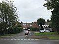
The neighbourhood is built with many cul-de-sacs. These are streets that are closed off at one end. They branch off four main roads. Each cul-de-sac has homes that look similar. But homes in different cul-de-sacs might look unique. This means each little street has its own style.
Community Life in Forestdale
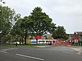
Forestdale has a special place called The Forum. It's a community centre located on Pixton Way. There's also a small group of shops. You can find them where Featherbed Lane meets Selsdon Park Road. Here, you'll see a pub called The Forestdale Arms. There's also a fish and chip shop named McDermott's. In 2005, it was even voted the best in London and the South-East!
A Glimpse into Forestdale's Past
Most of the houses in Forestdale were built between the late 1960s and mid-1970s. Before that, this area was open land. It had a few small farms. A building company called Wates Group built many of these homes. In 1972, they even won an award. This was for the special solar heating panels they put in some houses.
Getting Around Forestdale
It's easy to travel in and out of Forestdale.
Bus Services
Two London Buses routes serve the area. These are routes 353 and 433. They help people get around the neighbourhood and to other parts of London.
Tramlink Stops Nearby
All parts of Forestdale are close to a Tramlink tram stop. You can reach them within a mile.
- Fieldway
- Addington
- Gravel Hill (which you can also reach by bus)
Closest Train Stations
Several National Railway Stations are also within a few miles of Forestdale.
- West Wickham railway station: About two miles east. You can take a bus to get there.
- South Croydon: About three miles north.
- Sanderstead railway station: About three miles south-west.
Learning in Forestdale
Forestdale has good options for primary education.
Primary Schools
- Courtwood Primary School
- Forestdale Primary School
Famous Faces from Forestdale
- Rachel Chinouriri, a talented singer, is from Forestdale.
Images for kids
-
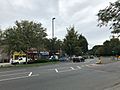
Shops on Selsdon Park Road
-
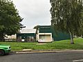
The Forum, a community centre
-
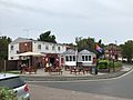
The Forestdale Arms pub
-
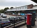
Forestdale Shopping Centre
-
Forestdale Primary School
-
Typical housing in Forestdale


