Selsdon facts for kids
Quick facts for kids Selsdon |
|
|---|---|
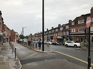
 Shops on Selsdon High Street |
|
| OS grid reference | TQ355625 |
| London borough | |
| Ceremonial county | Greater London |
| Region | |
| Country | England |
| Sovereign state | United Kingdom |
| Post town | SOUTH CROYDON |
| Postcode district | CR2 |
| Dialling code | 020 |
| Police | Metropolitan |
| Fire | London |
| Ambulance | London |
| EU Parliament | London |
| UK Parliament |
|
| London Assembly |
|
Selsdon is a lively area in South London, England. It's part of the London Borough of Croydon and is known for being a bit higher up, close to beautiful open countryside. Before 1965, it was actually part of Surrey, a different county. Now, it feels like a friendly suburb, a place where people live and work.
Contents
Selsdon's Past

The area where Selsdon is today used to be part of a big estate called Selsdon Park. This estate was famous for hunting and shooting. In the early 1920s, the large estate was split up into smaller pieces of land. These smaller pieces were often used for farming or building homes.
People became worried about how fast the village was growing. So, a group was formed to protect some land. They made sure that about 200 acres (0.8 square kilometers) were set aside. This land became a special nature reserve and a safe place for birds. It opened to the public in 1936.
The National Trust was given this land to look after. The local councils, Coulsdon and Purley Urban District Council and the Corporation of Croydon, agreed to manage it together. Today, this area is called Selsdon Wood. It has five large meadows surrounded by lots of trees and old hedges. It still feels like an ancient forest. You can even find old bomb craters in the wood and in a nearby recreation ground. Many wild animals live here, like deer and even parakeets.
Where is Selsdon?
Selsdon is located about 150 meters (492 feet) above sea level. A nearby area, Sanderstead Plantation, is even higher at 175 meters (574 feet).
The main shopping area in Selsdon is on Addington Road. Here, you'll find all sorts of shops, banks, and cafes. There's also a local Baptist Church and two pubs.
In 2007, a special clock was put up in Selsdon. It's called the Selsdon Clock and has a unique, rustic design. You can find it on the Selsdon Triangle, near the library and a Sainsbury's supermarket.
Selsdon Hall is a community space located under the Sainsbury's supermarket and library. It has a hall that people can rent for events. There's also a coffee shop that everyone can visit. It's a great place for local people to meet up.
Getting Around Selsdon
Trains and Trams
Selsdon used to have its own train station, but it was actually two miles away from the main area. This station closed in 1983.
Today, you can take a bus from Selsdon to East Croydon station. From there, you can catch trains to places like Gatwick Airport, Luton Airport, central London, and the South Coast. Two smaller stations, Sanderstead and South Croydon, are also about two miles from Selsdon.
If you prefer trams, there are Tramlink stops nearby. Gravel Hill is about 1.5 miles away, and Coombe Lane is about 2 miles from the town center.
Buses
Selsdon has several London Buses routes that connect it to other areas.
These buses can take you to Croydon Town Centre, New Addington, Purley, Croydon University Hospital, and Thornton Heath.
There are also buses run by Southdown PSV. Routes 409 and 411 connect Selsdon to towns like Caterham, Redhill, Godstone, Lingfield, and East Grinstead.
Who Lives in Selsdon?
In the 2011 census, information was collected about the people living in Selsdon and Ballards. This helps us understand the different groups that make up the community.
Here's a look at the main groups:
- White or White British: 80.1%
- Asian or Asian British: 10.4%
- Black or Black British: 5.2%
- Mixed/multiple ethnic groups: 2.6%
- Other ethnic groups: 1%
The largest single group was White British, making up 75.1% of the population.
 | Chris Smalls |
 | Fred Hampton |
 | Ralph Abernathy |


