Forrest County, Mississippi facts for kids
Quick facts for kids
Forrest County
|
|
|---|---|

|
|

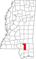
Location within the U.S. state of Mississippi
|
|
 Mississippi's location within the U.S. |
|
| Country | |
| State | |
| Founded | 1908 |
| Named for | Nathan B. Forrest |
| Seat | Hattiesburg |
| Largest city | Hattiesburg |
| Area | |
| • Total | 470 sq mi (1,200 km2) |
| • Land | 466 sq mi (1,210 km2) |
| • Water | 3.9 sq mi (10 km2) 0.8% |
| Population
(2020)
|
|
| • Total | 78,158 |
| • Estimate
(2023)
|
78,208 |
| • Density | 166.3/sq mi (64.2/km2) |
| Time zone | UTC−6 (Central) |
| • Summer (DST) | UTC−5 (CDT) |
| Congressional district | 4th |
Forrest County is a county located in the state of Mississippi in the United States. A county is like a smaller region within a state, often with its own local government.
As of the 2020 census, about 78,158 people lived here. The main city and county seat (where the county government is located) is Hattiesburg. Forrest County was created in 1908 from Perry County. It was named after Nathan Bedford Forrest, who was a general during the American Civil War. Forrest County is also part of the larger Hattiesburg, MS Metropolitan Statistical Area, which means it's connected to the bigger city of Hattiesburg.
Contents
Exploring Forrest County's Geography
Forrest County covers a total area of about 470 square miles. Most of this area, about 466 square miles, is land. The remaining 3.9 square miles (less than 1%) is water.
Main Roads and Highways
These are some of the important roads that go through Forrest County:
 Interstate 59
 U.S. Highway 11
 U.S. Highway 49
 U.S. Highway 98
 Mississippi Highway 13
 Mississippi Highway 42
Neighboring Counties
Forrest County shares its borders with several other counties:
- Jones County (to the northeast)
- Perry County (to the east)
- Stone County (to the south)
- Pearl River County (to the southwest)
- Lamar County (to the west)
- Covington County (to the northwest)
Protected Natural Areas
Part of the De Soto National Forest is located within Forrest County. This is a large forest area that is protected by the government.
Population in Forrest County
As of the 2020 United States census, there were 78,158 people living in Forrest County. The population has grown quite a bit over the years, showing that more and more people are choosing to live here.
Communities in Forrest County
Forrest County has several different types of communities, from busy cities to smaller, quieter areas.
Cities
- Hattiesburg: This is the largest city and the county seat. A small part of Hattiesburg is also in Lamar County.
- Petal
Census-Designated Places (CDPs)
These are areas that are like towns but are not officially incorporated as cities.
- Eastabuchie: Most of this area is actually in Jones County.
- Glendale
- Rawls Springs
Other Unincorporated Communities
These are smaller communities that are not part of any city or CDP.
Ghost Towns
- Riverside: This is a former town that is no longer inhabited.
Education in Forrest County
Forrest County has several school districts that serve its students:
- Forrest County Schools
- Hattiesburg Public School District
- Petal School District
There is also Forrest County Agricultural High School located in the county. For students who want to continue their education after high school, the county is part of the area served by Pearl River Community College.
See also
 In Spanish: Condado de Forrest para niños
 | Janet Taylor Pickett |
 | Synthia Saint James |
 | Howardena Pindell |
 | Faith Ringgold |

