Fort Ann (village), New York facts for kids
Quick facts for kids
Fort Ann
|
|
|---|---|
|
Village
|
|

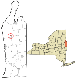
Location in Washington County and the state of New York.
|
|
| Country | United States |
| State | New York |
| County | Washington |
| Metro Area | Glens Falls, New York |
| Town | Town of Fort Ann |
| Fort Built | 1757 |
| Incorporated | 1820 |
| Area | |
| • Total | 0.29 sq mi (0.76 km2) |
| • Land | 0.29 sq mi (0.74 km2) |
| • Water | 0.01 sq mi (0.02 km2) |
| Elevation | 157 ft (48 m) |
| Population
(2020)
|
|
| • Total | 460 |
| • Density | 1,608.39/sq mi (621.99/km2) |
| Time zone | UTC-5 (Eastern (EST)) |
| • Summer (DST) | UTC-4 (EDT) |
| ZIP code |
12827
|
| Area code(s) | 518 |
| FIPS code | 36-26704 |
| GNIS feature ID | 0950461 |
| Website | www.fortann.us<defunct> |
Fort Ann is a small village located in Washington County, New York, United States. It is part of the larger Glens Falls Metropolitan Statistical Area. In 2010, about 484 people lived there. The village's name comes from Queen Anne. A fort was built here in 1757 and named after her.
The village of Fort Ann is found within the larger town of Fort Ann. It sits where two important roads meet: U.S. Route 4 and New York State Route 149.
History of Fort Ann
The area where Fort Ann is located has a long military history. Several forts were built here between 1690 and 1777. These forts were important during different wars. The first fort was built during King William's War. The last one was built during the American Revolution. Some early forts were known as "Fort Schuyler" and the "Queen's Fort."
Fort Ann was also the site of a battle in 1777. This was the Battle of Fort Anne, which was part of the Saratoga Campaign during the American Revolution.
The village of Fort Ann officially became a village in 1820. A few years later, in 1823, the Champlain Canal was finished. This canal helped transport goods and people. Later, the Delaware & Hudson Railroad also came through the village.
The Old Stone House Library is an important building in Fort Ann. It was added to the National Register of Historic Places in 2012. This means it's a special place with historical value.
Geography of Fort Ann
Fort Ann is a small village. According to the United States Census Bureau, its total area is about 0.3 square miles (0.76 square kilometers). All of this area is land.
The village is located right next to the town lines of Kingsbury and Hartford.
Besides U.S. 4 and NY 149, another road called County Road 4 also enters the village.
Population of Fort Ann
| Historical population | |||
|---|---|---|---|
| Census | Pop. | %± | |
| 1870 | 639 | — | |
| 1900 | 431 | — | |
| 1910 | 436 | 1.2% | |
| 1920 | 338 | −22.5% | |
| 1930 | 389 | 15.1% | |
| 1940 | 439 | 12.9% | |
| 1950 | 463 | 5.5% | |
| 1960 | 453 | −2.2% | |
| 1970 | 562 | 24.1% | |
| 1980 | 509 | −9.4% | |
| 1990 | 419 | −17.7% | |
| 2000 | 471 | 12.4% | |
| 2010 | 484 | 2.8% | |
| 2020 | 460 | −5.0% | |
| U.S. Decennial Census | |||
In 2000, there were 471 people living in Fort Ann. These people lived in 187 households, and 127 of these were families. The village had about 1,570 people per square mile.
The average household in Fort Ann had about 2.52 people. The average family had about 3.01 people.
The people in Fort Ann were of different ages. About 22.9% were under 18 years old. About 15.3% were 65 years old or older. The average age in the village was 37 years.
See also
 In Spanish: Fort Ann (villa) para niños
 | Bayard Rustin |
 | Jeannette Carter |
 | Jeremiah A. Brown |

