
Fortymile Gulch facts for kids

Fortymile Gulch and Willow Gulch are two amazing canyons in southern Utah. They are like natural waterways that flow into the Escalante River. You can find them in Kane County, a beautiful part of the western United States. These gulches stretch for more than 20 miles (about 30 kilometers) combined!
They show off many cool rock features, just like other parts of the Canyons of the Escalante. Imagine tall canyon walls, clear water pools, super narrow slot canyons, big rock domes, and even natural arches. These places are popular for outdoor fun and are part of the Grand Staircase–Escalante National Monument.
Exploring Fortymile Gulch
The journey of Fortymile and Willow Gulches begins high up on the Straight Cliffs. These cliffs form the eastern edge of the Kaiparowits Plateau. Small streams that only flow sometimes join together to create bigger branches. These branches then carve deep canyons, sometimes as deep as 500 feet (150 meters), into the sandstone rock. Eventually, they meet the main channel of the Escalante River.
Fortymile Gulch is the northernmost branch. It's famous because a group of pioneers, called the San Juan Expedition, camped here in the winter of 1879. They were trying to start a new town in southeastern Utah. They waited at a spot called Fortymile Springs while a smaller group bravely prepared a very difficult path down to the Colorado River at a place known as Hole-in-the-Rock.
Close by, you can see Dance Hall Rock. This is a cool, dome-shaped rock made from Entrada Sandstone. The lower part of Fortymile Gulch is super narrow. It has many slot canyons and water pools before it joins up with Willow Gulch.
Discovering Willow Gulch

Willow Gulch is sometimes called Sooner Gulch on maps. This southern part of the canyon is where you'll find some of the most amazing sights. At the start of one of its branches, there's another group of sandstone domes called the Sooner Rocks.
You can get to the bottom of Willow Gulch from a path right off the Hole-in-the-Rock Road. About a mile downstream, you'll discover the incredible Broken Bow Arch. It got its name because a Native American artifact, like a broken bow, was found nearby. This arch is huge! It's about 94 feet (29 meters) wide and 100 feet (30 meters) high. It's a great example of how Navajo Sandstone can form such beautiful arches.
Further down the canyon, you'll walk through a deep pool of water in a very narrow slot canyon. Then, Willow Gulch joins the main part of Fortymile Gulch and two other streams coming from the north. From there, the combined gulches continue down to the Escalante River. Keep in mind that some of this lower section might be underwater now, depending on how high Lake Powell is behind the Glen Canyon Dam.
Images for kids
-
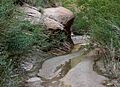
Streambed
-
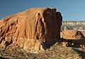
Sooner Rocks
-

Canyon Walls


