Gee (navigation) facts for kids
Gee, also known as GEE, was a special radio navigation system. It was used by the Royal Air Force (RAF) during World War II. This system helped pilots find their way by measuring how long it took for two radio signals to arrive.
Gee could figure out a plane's exact spot within a few hundred meters. It worked up to about 560 kilometers (350 miles) away. It was the first "hyperbolic navigation" system used in real operations. It started helping RAF Bomber Command in 1942.
A scientist named Robert Dippy first thought of Gee. He wanted it to be a short-range system to help planes land safely at night. But as they developed it, scientists at the Telecommunications Research Establishment (TRE) found it worked much farther than they expected.
So, Gee became a long-range navigation system. It was accurate enough to help bombers hit large targets like cities at night. This meant they didn't always need to use a special bombsight. Later, enemies tried to block the signals (called jamming). This made Gee less useful for bombing. However, it remained a very important navigation tool in the UK during and after the war.
After the war, Gee was still a key part of the RAF's navigation tools. It was used on planes like the English Electric Canberra and the V-bombers. It was also used by civilian planes across Europe. The system began to be turned off in the late 1960s. The last station stopped working in 1970. Gee also inspired the first LORAN system, which was another navigation tool.
How Gee Was Developed
The basic idea of using radio waves to find a location was known in the 1930s. But the special equipment needed to make it work wasn't widely available. The biggest challenge was measuring tiny differences in signal timing, down to millionths of a second (micro-seconds).
In the 1930s, the invention of radar helped solve this problem. Radar needed devices that could measure signal timings very accurately. For example, the British Chain Home radar system used a screen called an oscilloscope. This screen showed radio signals as "blips." By measuring how far a blip moved on the screen, scientists could calculate the time difference. This helped them figure out the distance to an airplane or target.
Radar could also be used for navigation. Two ground stations could measure the distance to a plane. Then they could use simple math to find the plane's location. This information would then be sent to the plane. However, this method needed a lot of people to work it. It could usually only guide one plane at a time.
A System for Landing Planes
In October 1937, Robert J. Dippy, who worked at a radar lab, had an idea. He suggested using two radio transmitters working together to help planes land in bad weather or at night. He imagined two antennas placed about 16 kilometers (10 miles) apart near a runway. A central transmitter would send a signal to both antennas at the exact same time.
A receiver in the airplane would pick up these signals. It would show them on a screen like the radar displays. If the plane was perfectly lined up with the runway, both signals would arrive at the same time. They would show up as one blip on the screen. If the plane was off to one side, one signal would arrive before the other. This would create two separate blips. Pilots could then see which signal arrived first. This told them which way to turn to get back on track.
The head of the lab, Robert Watson-Watt, liked the idea. But at the time, the RAF mainly bombed during the day. So, night landings weren't a big worry. Radar development was seen as more urgent.
The RAF's daytime bombing plans didn't work out well. Bombers were easily shot down by ground fire and enemy fighters. So, the RAF decided to go back to night bombing. This meant they needed better ways to land and navigate at night.
Dippy improved his system for this new purpose. He presented his new idea in June 1940. His original design used two transmitters to create one line in space, like a runway centerline. In his new plan, maps would show not just the line where signals arrived at the same time. They would also show lines where signals arrived one millionth of a second apart, two millionths of a second apart, and so on.
This would create a grid of lines on navigation maps. If a plane could measure the time difference from two pairs of transmitters, it could find its exact spot on the grid. To make this easier, Dippy suggested using a central station. This central station would be part of two pairs of transmitters, arranged like the letter "L". By measuring the time delays from the two outer stations compared to the center, a plane could find its position. The grid lines on the maps gave the system its name: "Gee" for "Grid."
Since the system now covered a much larger area, the transmitters needed to be farther apart. Dippy suggested a new system. One "master" station would send out a signal based on a timer. Other "secondary" stations would listen for this signal. When they received it, they would send out their own signals. This kept all the stations in sync without needing wires between them. Dippy suggested a master station and three secondary stations. They would be about 130 kilometers (80 miles) away from the master, forming a large "Y" shape. A group of such stations was called a "chain."
Testing began in June 1940. Everyone was surprised and happy to find that Gee worked well up to at least 480 kilometers (300 miles) at an altitude of 3,000 meters (10,000 feet).
Gee Helps the Bombing Campaign
The discovery of Gee's long range came at a very important time for the RAF's bombing efforts. The RAF had not focused much on night navigation skills. When Germany started its night bombing attacks on Britain (the "Blitz"), the Germans used radio aids like the X-Gerät system.
By late 1940, reports showed that Allied bombers were often missing their targets. Some bombs fell over 80 kilometers (50 miles) away! An official report, called the Butt report, showed that only 5% of bombs landed within 8 kilometers (5 miles) of their targets. This meant that bombing factories and other specific targets was almost impossible. This led to a new plan to bomb German cities and homes instead.
While these debates went on, Bomber Command slowed down its attacks. They waited for new, larger 4-engine bombers like the Handley Page Halifax and Avro Lancaster to arrive. They also waited for Gee to be ready. Gee, combined with the new heavy bombers, would provide the accuracy and bomb power needed for the new strategy. Testing and deploying Gee became a top priority. Gee was not the only solution; it was soon joined by H2S radar and the Oboe system.
Almost Discovered by the Enemy
At first, there weren't many Gee devices available. So, the idea of a pathfinder force was adopted. This meant a special group of planes would use Gee to drop flares. These flares would then act as aiming points for other bombers following behind.
Prototype Gee sets were used on target indicator planes even before many production sets were ready. In May 1941, one such set gave an accurate fix at 640 kilometers (400 miles) away. The first full Gee transmitter chain was finished in July 1941. But during testing, the sets proved unreliable. This was fixed during that summer.
On the night of August 11-12, two Gee-equipped planes bombed targets using only Gee coordinates. They showed "uncanny accuracy." However, the next night, on a raid over Hanover, a Vickers Wellington plane with a Gee set was lost. The Gee set did not have a self-destruct system. It might have fallen into German hands. All operational testing was immediately stopped.
R. V. Jones, a British intelligence officer, started a plan to hide the system's existence. First, they stopped using the code name 'Gee' in messages. They sent fake messages talking about a made-up system called 'Jay'. They hoped this would confuse the Germans. A double agent also told German intelligence a made-up story. He said he heard RAF personnel talking carelessly about Jay, and one said it was "just a copy" of the German Knickebein system. Jones thought this would flatter the Germans and make them believe the story.
Despite these efforts, Jones thought the Germans would be able to jam the system in only three months. But jamming didn't become a serious problem until five months into the campaign.
Gee Enters Service
Even with limited testing, Gee was easy to use and accurate enough. On August 18, 1941, Bomber Command ordered Gee to be mass-produced. The first sets were expected in May 1942. Overall, 60,000 Gee sets were made during World War II. They were used by the RAF, the US Army Air Forces (USAAF), and the Royal Navy.
The first real mission using Gee happened on the night of March 8-9, 1942. About 200 planes attacked Essen. A Gee set was installed on a Vickers Wellington plane. The pilot, Jack Foster, later said, "targets were found and bombed as never before." While the main target, Krupp, was missed, bombs did hit the southern parts of the city. In total, 33% of the planes reached the target area. This was a huge improvement over earlier results.
The first completely successful Gee-led attack happened on March 13-14, 1942, against Cologne. The leading crews successfully lit up the target with flares. The bombing was generally accurate. Bomber Command figured this attack was five times more effective than an earlier raid on the city. Gee's success led to a new plan. They decided to bomb 60 German cities within Gee's range.
To cover the entire UK, three Gee chains were built. The first chain started working continuously on June 22, 1942. A chain in Scotland followed later that year, and a southwest chain in 1943. Even when German jamming started, Gee remained very useful for short-range navigation over the UK. Only 1.2% of planes with Gee failed to return to base, compared to 3.5% of those without it. Gee was considered so important that a plane with a broken Gee set would not be allowed to fly.
An example of Gee's use was during Operation Chastise (the "Dam Buster Raid") in May 1943. The raid's leader, Guy Gibson, mentioned his navigator using a "G Box" (Gee) to figure out how fast they were flying. This happened while flying very low at night over the North Sea.
Gee Gets Upgrades
The first serious jamming happened on the night of August 4-5, 1942. It grew stronger as bombers got closer to their target at Essen. The signals became unusable about 16 to 32 kilometers (10 to 20 miles) from the target. However, the newly built southern chain was not yet known to the Germans and continued to be useful. On December 3-4, a fix was made from this chain over Turin in Italy, at a range of 1,175 kilometers (730 miles). This was the longest operational use of Gee.
Scientists had already thought about ways to fight jamming. This led to the Gee Mk. II. This new version had a receiver where parts could be easily changed. This allowed it to work on different radio frequencies. These included the original 20–30 MHz band, as well as new bands at 40–50, 50–70, and 70–90 MHz. The navigator could change these parts during flight. This allowed them to receive signals from any active chain. Gee Mk. II started working in February 1943. The US 8th Air Force also chose to use it.
In April 1942, the plan to develop mobile Gee stations was approved. These would be used for the invasion of Europe. This would extend the system's range eastward. It would also allow stations to move if jamming became a problem. The first of three such mobile chains was ready in November 1943. It started working in May 1944 in Foggia, Italy. Other units were sent into France soon after D-Day.
After the war in Europe ended, Britain planned to send bombers to fight Japan. They would use Gee to guide flights to Asia. Preparations began for Gee transmitters in Nablus (in Palestine). But Japan surrendered, so this chain was not needed.
German bombers also used the Gee system to attack the UK. They used captured Gee receivers to do this.
Gee-H: A New Way to Bomb
Later in the war, Bomber Command wanted a new navigation system. It wasn't just for finding a location. It was for marking a single spot in the air. This spot would be used to drop bombs or target markers for other bombers. The Oboe system already did this. Oboe sent a signal from UK stations. It bounced off special equipment on the plane. Then it timed the difference between the two signals, similar to Gee. However, Oboe could only guide one plane at a time. It took about 10 minutes to guide a single plane to its target. A system that could guide more planes at once would be a big improvement.
This led to a new version of the Oboe idea. But this time, the plane sent the signal, and it bounced off ground stations. This meant the plane needed equipment to receive and measure the time difference between two signals. It was clear that the existing Gee equipment could be used for this. The new Gee-H system only needed one change: adding a new transmitter on the plane. This transmitter would send signals to bounce off the ground stations. When this transmitter was turned off, the system worked like a normal Gee unit. This allowed planes to use Gee-H for attacks and then switch back to regular Gee for navigation back to their airfields.
This method made the navigator's job much easier. For most of the mission, they just had to keep the blips on the top line aligned. Then, they would watch the lower blips for the right moment to drop bombs. Also, because measurements were direct lines from the station, Gee-H was much more accurate. It could guide a bomber to within 110 meters (120 yards) over Germany. This was a huge improvement over Gee's 1.6-kilometer (1-mile) accuracy at the same distance.
Gee After the War
Gee was so useful that the temporary setups during the war became a permanent navigation system. Four chains were set up in the UK: South Western, Southern, Scottish, and Northern. These covered most of the UK. Two more chains were added in France, and one in Germany.
How Gee Worked
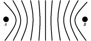
Hyperbolic navigation systems work by measuring the time difference between radio pulses.
Imagine two radio transmitters 300 kilometers (186 miles) apart. A radio signal from one would take 1 millisecond (one-thousandth of a second) to reach the other. One station, called A, sends out a signal. One millisecond later, that signal reaches the second station, B. Station B then sends out its own signal. This makes sure the stations send signals exactly 1 millisecond apart.
A receiver on a plane picks up these signals and shows them on a screen. By measuring the distance between the "blips" on the screen, the time delay can be figured out. For example, if the delay is 0.5 milliseconds, it means the difference in distance to the two stations is 150 kilometers (93 miles). Many locations could have that same delay.
When these possible locations are drawn on a map, they form a curved line called a "hyperbolic curve." All the possible curves for different delays create a set of curved lines. These lines are centered on the line between the two stations, called the "baseline." To find its exact spot, a plane takes two measurements from two different pairs of stations. The points where these two sets of curves cross give the plane's location. Usually, there are two possible locations. Using other navigation methods, like dead reckoning, the pilot can figure out which one is correct.
Instead of using two separate pairs of stations, Gee used one "master" station and two or three "secondary" stations. These stations were placed far enough apart so their signal patterns overlapped. A group of these stations was called a "chain."
Gee Chains
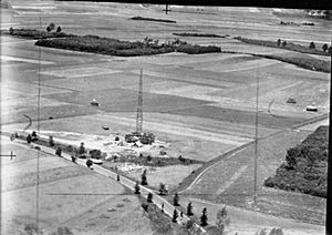
Gee chains used one master station and two or three slave (secondary) stations. The transmitters were powerful, sending out signals around 300 kilowatts (kW). They used four different frequency bands between 20 and 85 megahertz (MHz).
The Gee signal for a chain was a series of short radio pulses. In a three-station system, the master station sent a single pulse, called A. Two milliseconds later, it sent a double pulse, A′ (A Prime). The first slave station sent a single pulse, B, one millisecond after the master's single pulse. The second slave sent a single pulse, C, one millisecond after the master's double pulse. The A′ double pulse helped the navigator know the order of the signals. This whole sequence repeated 250 times per second, in the pattern A-B-A′-C.
Reading the Signals
On the plane, the signals from the stations were received and shown on a screen.
First, the navigator would adjust the screen to make the blips stand still. This meant the plane's receiver was in sync with the master station. Then, the navigator would identify the pulses. They would use controls to line up the B pulse under the A pulse, and the C pulse under the A′ pulse.
A special switch would then change the display to show a scale. The navigator would read numbers from this scale. These numbers, from the A-B and A′-C readings, would be plotted on a special map with a grid of lines. This would show the plane's location.
To tell different chains apart, the A′ signals would blink on and off in a specific pattern. This helped the operator know which chain they were using.
How Accurate Was Gee?
Gee's accuracy depended on how far the plane was from the transmitters. At shorter distances, the lines on the map crossed at angles close to 90 degrees, which gave very accurate readings. But as the distance increased, the lines became more parallel, making the readings less accurate.
When looking at the signal on the screen, timing was very precise. It was based on tiny units of time. At short ranges, Gee could be accurate to about 150 meters (165 yards). At long ranges over Germany, it was accurate to about 1.6 kilometers (1 mile).
Gee Equipment
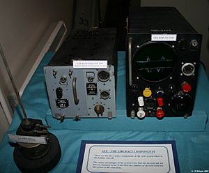
The Gee Mk. II system on the plane had two main parts: the R1355 radio receiver and the Indicator Unit Type 62 (or 62A) screen. These two parts were connected by thick cables. The R1355 receiver was designed so that its radio frequency unit (RFU) could be easily swapped out during flight. This allowed the navigator to switch between different Gee chains. It also helped avoid jamming, as the Germans wouldn't know which chains were being used.
Gee's Strengths and Weaknesses
Unlike German "beam systems" where bombers flew along a specific radio beam, Gee pulses were sent in all directions. This meant that if the signals were detected, they wouldn't reveal where the bombers were going. Also, because the system was "passive" (it only received signals, not sent them out to find targets like H2S), it didn't give away the bombers' positions to night fighters. Plus, all planes could use the system at the same time.
Gee was very easy to jam. The Germans just had to send out fake radio pulses. These fake pulses would make it impossible to tell which signals were real from the stations and which were from a jammer. This was easy to do by setting up another "slave" station in France or the Netherlands. Even if jammed over enemy territory, Gee was still very useful. It provided a reliable navigation fix once planes were over the North Sea on their way back from missions. This made it easier for bombers to find their airfields, which meant fewer planes were lost due to accidents.
Gee Stations
World War II Chains
Each Gee chain had a code word, often using the names of American states. This was to suggest it was for American planes.
Eastern Chain
This chain became fully operational in March 1942. It was used in major, successful raids on Lübeck and Cologne. Its master station was at Daventry, Northamptonshire.
Southern Chain
This chain could not operate at the same time as the Eastern chain. Its master station was at Bulbarrow Hill.
South-Eastern Chain
Its master station was at Truleigh Hill.
Northern Chain
The Northern Gee chain operated from late 1942 until March 1946. Its master station was at Burifa Hill on Dunnet Head, in Caithness, Scotland.
South Western Chain
Its master station was at Sharpitor.
North-Eastern Chain
Operational from April 18, 1944. Its master station was at Richmond, Yorkshire.
North Western Chain
This chain was operational for about six months in 1945. Its master station was at Saligo Bay.
Post D-Day Chains in Europe
After D-Day, several mobile Gee chains were set up in Europe to support the advancing Allied forces. These provided coverage deeper into Germany. Some of these chains included:
- Channel Chain: Operational from August 23, 1944, near Cherbourg.
- Rheims Chain: Operational from October 5, 1944, with its master station in Rheims.
- Louvain / Ruhr Chain: Operational from October 9, 1944, with its master station in Louvain.
- Saar Chain: Operational from March 21, 1945, with its master station in St Avold.
- Frankfurt Chain: Its master station was in Roermond.
- Kassel / Central German Chain: Its master station was in Winterberg.
- Munich Chain: Operational from April 26, 1945, with its master station in Hesselburg.
Post-World War II Chains
After World War II, the Gee system was still used for civilian aircraft navigation. Many new sites were built.
English Chains
After the war, the RAF moved two of the three wartime Gee chains in England. The Eastern and South Western chains (four stations each) and the Southern chain (three stations) were reorganized. The Southern chain became a four-station London chain, and the Eastern chain became a Midland chain. This was planned for 1948.
Northern Chain
This chain continued to operate after World War II using existing sites in Scotland and Shetland.
Scottish Chain
Opened around 1948 and closed in early 1969. Its master station was at Lowther Hill.
Other Chains
A chain of Gee stations opened after the war in North Germany. Stations were at Winterberg, Bad Iburg, Nordhorn, and Uchte.


