
Gabriel de Vallseca facts for kids
.jpg)
Gabriel de Vallseca was a famous mapmaker from the 1400s. He was born in Barcelona, Spain, sometime before 1408, and lived in Palma until after 1467. Gabriel was part of the Majorcan cartographic school, a group of skilled mapmakers from Majorca. His most well-known map is from 1439. It was the first map to show the Azores islands, which had only just been discovered.
Contents
His Life
Gabriel de Vallseca was born in Barcelona. His family had a Jewish background and had converted to Christianity. Some people think his father was Haym ibn Risch, who changed his name to Juan de Vallsecha after converting. Others believe Gabriel had family in Majorca through his mother or wife.
By 1433, Vallseca had moved from Barcelona to Palma, Majorca. There, he quickly became known as a master mapmaker. He also made tools and worked as a merchant. He lived in a busy part of the city, close to the sea and shops.
Gabriel married Floreta Miró, and they had two sons, Francesc and Joan. Later, his sons faced issues with the Spanish Inquisition. This was a time when people were questioned about their religious beliefs. The problems his sons faced suggest that Gabriel might have secretly kept some Jewish traditions. Gabriel de Vallseca wrote his last will in 1467 and passed away shortly after.
His Maps
.jpg)
Gabriel Vallseca signed three portolan charts that still exist today. Portolan charts were special maps used by sailors. They showed coastlines and harbors in great detail.
- A map from 1439, found at the Maritime Museum of Barcelona. This map shows a large part of the world.
- A map from 1447, kept at the Bibliothèque nationale de France in Paris. This map focuses only on the Mediterranean Sea.
- A map from 1449, located at the Archivio di Stato di Firenze in Italy. This map also shows only the Mediterranean Sea.
There are also two other maps that experts believe he made, even though they don't have his signature:
- An undated map (thought to be from around 1440) at the Biblioteca Nazionale Centrale di Firenze. This map shows a large part of the world.
- An undated map (thought to be from around 1447) at the Bibliothèque nationale de France. This map only has parts of the eastern Mediterranean.
Vallseca's maps looked like those from the traditional Majorcan cartographic school. However, he also added new ideas from mapmakers in Italy, Portugal, and other places. For example, he made the scale of the Mediterranean and Atlantic oceans more consistent.
His maps also had special Majorcan decorations. These included a wind rose (a symbol showing wind directions). They also featured tiny drawings of people, animals, and plants. Mountains like the Atlas Mountains were shaped like a palm tree. The Alps looked like a chicken's foot. Other places had unique shapes too, like Bohemia as a horseshoe. Rivers like the Danube looked like a chain, and the Tagus like a shepherd's crook. The Red Sea was colored red. Many notes and labels on his maps were written in the Catalan language.
The 1439 Map

Vallseca's 1439 map is his most famous. It's special because it shows new lands discovered by captains working for Prince Henry the Navigator of Portugal. The map shows the Atlantic Ocean from Scandinavia down to Rio de Oro. It includes the Atlantic islands like the Azores, Madeira, and Canaries. It also shows some imaginary islands like Thule and Brazil.
The most important part is how it shows the Azores islands. These islands were officially discovered in 1431. Vallseca's map was the first to show them, even though their spacing was a bit off. It correctly showed them stretching from southeast to northwest.
The 1439 map has Vallseca's signature. It says, "Gabriell de Valsequa made this in Majorca, in the year 1439." A note on the back says that the explorer Amerigo Vespucci once owned this map. He paid 80 gold coins for it! People think Vespucci bought it in Florence in the 1480s. He might even have taken it with him on his voyages to the New World between 1497 and 1504.
Cardinal Antonio Despuig y Dameto bought the 1439 Vallseca map in Florence before 1785. It then went to his family, the Counts of Montenegro. The map had an accident in 1838 or 1839. The Count was showing it to his guests, Frédéric Chopin and George Sand. An inkwell tipped over, spilling ink on the map. This caused permanent smudges and made some labels on the western part of the map hard to read.
The ink spill especially damaged a very important note about the discovery of the Azores. The note now reads:
These islands were found by Diego de ??? pilot of the King of Portugal in the year 14??
The last name of the pilot and part of the date are smudged. Because of this, historians have tried to guess the missing parts. For example, some think the pilot's name was "Guullen" or "Diogo de Silves." The date has been guessed as 1427, 1432, or 1437.
Vallseca's map names eight or nine islands of the Azores. These names are also hard to read because of the ink. Early readings identified islands like Santa Maria, São Miguel, and Terceira. The map even showed Corvo and Flores, which were not officially discovered until 1452. Vallseca likely copied these two islands from an older map called the Catalan Atlas from 1375.
In 1910, the Count of Montenegro sold the 1439 map. It was bought by Pere Bosc i Oliver, who then sold it to the Institute of Catalan Studies. They placed it at the National Library of Catalonia in Barcelona in 1917. In 1960, it moved to the Maritime Museum of Barcelona, where you can see it today.
A copy of the map was made in 1892 for an exhibition. This copy is now at the Naval Museum of Madrid.
Images for kids
-
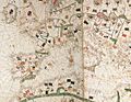
Western part of a map likely by Vallseca (around 1440).
-
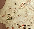
A piece of a map likely by Vallseca, showing the Black Sea (around 1447).
-
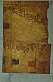
Western part of Vallseca's 1449 map.
.jpg)
.jpg)

See also
 In Spanish: Gabriel de Vallseca para niños
