Ganaraska River facts for kids
Quick facts for kids Ganaraska River |
|
|---|---|

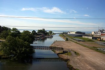
The Ganaraska River flowing through Port Hope to its mouth at Lake Ontario
|
|
|
Location of the mouth of the Ganaraska River in southern Ontario
|
|
| Country | Canada |
| Province | Ontario |
| Region | Southern Ontario |
| Districts |
|
| Physical characteristics | |
| Main source | Ganaraska Forest on the Oak Ridges Moraine Clarington, Regional Municipality of Durham 344 m (1,129 ft) 44°03′15″N 78°36′22″W / 44.05417°N 78.60611°W |
| River mouth | Lake Ontario Port Hope, Northumberland County 74 m (243 ft) 43°56′30″N 78°17′26″W / 43.94167°N 78.29056°W |
| Basin features | |
| River system | Great Lakes Basin |
| Basin size | 278 km2 (107 sq mi) |
| Tributaries |
|
The Ganaraska River is a cool river in Southern Ontario, Canada. It flows through Northumberland County and the Regional Municipality of Durham. This river is part of the huge Great Lakes Basin. It eventually flows into Lake Ontario at the town of Port Hope. People think the river's name comes from Ganaraske. This was the name of a Cayuga village that used to be where Port Hope is now.
Contents
Where Does the Ganaraska River Start?
The Ganaraska River begins in the Ganaraska Forest. This forest is located on the Oak Ridges Moraine in Clarington. The river's starting point is about 1.5 kilometers (0.9 miles) southeast of where Highway 35 and Highway 115 meet.
The River's Journey South
From its start, the river flows mostly southeast. It passes by a small community called Kendal. Along its way, another river, the North Ganaraska River, joins it from the left side. After this, the Ganaraska River turns south. It continues flowing until it reaches its end at the northern shore of Lake Ontario.
What is the Ganaraska River Watershed?
A watershed is an area of land where all the water drains into a single river or lake. The Ganaraska River's watershed covers about 278 square kilometers (107 square miles).
Areas Covered by the Watershed
Even though the river flows mainly through Northumberland County and Durham, its watershed is quite large. Parts of it reach into other areas, including:
- The City of Kawartha Lakes
- The Township of Cavan–Monaghan in Peterborough County
- The Township of Hamilton in Northumberland County
Conservation Efforts and Fish Life
In recent years, many people have worked hard to protect the Ganaraska River. These efforts help keep the river healthy for both nature and people.
Fishing and Fish Ladders
The river is a popular spot for fishing. Anglers, which are people who fish, come here to catch salmon and trout. A special structure called the Ganaraska River Fishway helps fish. This fish ladder allows fish like rainbow trout to swim upstream. They use it to reach areas where they can lay their eggs.
The Great Flood of 1980
The Ganaraska River has seen some big events. In 1980, the river experienced a major flood. This flood caused a lot of damage. The downtown area of Port Hope was especially affected.
 | DeHart Hubbard |
 | Wilma Rudolph |
 | Jesse Owens |
 | Jackie Joyner-Kersee |
 | Major Taylor |


