Garbutt, Queensland facts for kids
Quick facts for kids GarbuttTownsville, Queensland |
|||||||||||||||
|---|---|---|---|---|---|---|---|---|---|---|---|---|---|---|---|

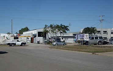
View towards Leyland Street from Lazzaroni Street
|
|||||||||||||||
| Population | 2,309 (2021 census) | ||||||||||||||
| • Density | 192.4/km2 (498/sq mi) | ||||||||||||||
| Postcode(s) | 4814 | ||||||||||||||
| Area | 12.0 km2 (4.6 sq mi) | ||||||||||||||
| Time zone | AEST (UTC+10:00) | ||||||||||||||
| Location |
|
||||||||||||||
| LGA(s) | City of Townsville | ||||||||||||||
| State electorate(s) | Townsville | ||||||||||||||
| Federal Division(s) | Herbert | ||||||||||||||
|
|||||||||||||||
Garbutt is a suburb located in Townsville, Queensland, Australia. It's a special place because it's home to the Townsville International Airport and a big air force base called RAAF Base Townsville. In 2021, about 2,309 people lived in Garbutt.
Contents
What Garbutt Looks Like
Garbutt is divided into different areas. The eastern part is where people live in homes. The southern part is an industrial area, which means it has lots of factories and businesses. The northern part is mainly for the airport.
The Airport Area
The airport area in Garbutt includes:
- The Townsville International Airport, which used to be called Garbutt Airport.
- The RAAF Base Townsville, which is a base for Australia's air force.
- A heliport, which is a place where helicopters take off and land.
- The Townsville station of the Bureau of Meteorology, where they study the weather.
Transport in Garbutt
A railway line, called the North Coast railway line, runs through Garbutt. There's also a train stop called Garbutt railway station. Several important roads cross through or along the edges of the suburb, like North Townsville Road and Garbutt–Upper Ross Road.
Garbutt's Past
The land where Garbutt is located has a long history. It is the traditional country of the Wulgurukaba Aboriginal people.
How Garbutt Got Its Name
The suburb got its name from a railway stop that was first called Garbutts Siding. This siding was used by a meat business owned by the sons of Charles Overend Garbutt. In 1940, the railway department officially renamed the stop to Garbutt, and the suburb took that name too.
Churches in Garbutt's History
A Methodist church opened in Garbutt in 1936. Later, in 1964, a new Methodist church was built. This church became a Uniting Church when the Methodist, Presbyterian, and Congregational churches joined together. The church grew so much that in 1986, the congregation moved to an even bigger church called House of Praise in a nearby suburb, Mount Louisa. St Theresa's Catholic Church also opened in Garbutt in 1968.
RAAF Base Townsville
The RAAF Base Townsville was set up on October 15, 1940. During World War II, air forces from the United States also used this base.
People in Garbutt
In 2021, Garbutt had a population of 2,309 people. In 2016, about 13.1% of the people living there were Aboriginal and Torres Strait Islander. Most people (72.2%) were born in Australia, and most (78.1%) spoke only English at home.
Learning in Garbutt
Garbutt has one primary school:
- Garbutt State School is a government primary school for students from Prep to Year 6. It's located on Chandler Street. In 2018, it had 91 students.
There isn't a high school in Garbutt itself. Students who want to go to secondary school usually attend Pimlico State High School in the nearby suburb of Gulliver.
Places to Visit and Things to Do
Shopping
You can find places to shop at the Garbutt Shopping Village.
Churches
- St Theresa's Catholic Church is located on Lonerganne Street.
Parks
Garbutt has several parks where you can relax and play:
- Harold Phillips Park
- Melrose Park
- Spilsbury Park
Community Groups
The Magnetic Garbutt branch of the Queensland Country Women's Association (CWA) meets at the CWA Hall on Lancaster Street. This group helps women and communities in rural areas.
Attractions
- The RAAF Townsville Aviation Heritage Centre is a museum that tells the story of military aviation in North Queensland. It's located on Ingham Road. It has been temporarily closed since March 2020.
 | Tommie Smith |
 | Simone Manuel |
 | Shani Davis |
 | Simone Biles |
 | Alice Coachman |


