
Nether Providence Township, Pennsylvania facts for kids
Quick facts for kids
Nether Providence Township
|
|
|---|---|
|
Township
|
|

Wolley Stille, ca. 1692-1700
|
|
| Motto(s):
A beautiful place to call home
|
|

Location in Delaware County and the U.S. state of Pennsylvania
|
|
| Country | United States |
| State | Pennsylvania |
| County | Delaware |
| Area | |
| • Total | 4.72 sq mi (12.23 km2) |
| • Land | 4.71 sq mi (12.21 km2) |
| • Water | 0.01 sq mi (0.02 km2) |
| Elevation | 240 ft (70 m) |
| Population
(2010)
|
|
| • Total | 13,706 |
| • Estimate
(2016)
|
13,779 |
| • Density | 2,923.62/sq mi (1,128.76/km2) |
| Time zone | UTC-5 (EST) |
| • Summer (DST) | UTC-4 (EDT) |
| Area code(s) | 610 |
Nether Providence Township is a special kind of town called a first class township in Delaware County, Pennsylvania, United States. Many people who live here often call it "Wallingford." This is because the main postal code for most of the township is Wallingford. In 2010, about 13,706 people lived in Nether Providence.
Contents
Exploring Nether Providence's Location
Nether Providence Township is located in the middle of Delaware County. It's next to the town of Media, which is the main town for the county.
What Towns Are Nearby?
Other towns and areas close to Nether Providence include:
- Upper Providence Township to the north
- Springfield Township, the town of Swarthmore, and Ridley Township to the east
- The city of Chester to the south
- The towns of Brookhaven and Rose Valley to the west
Land and Water Features
The township covers about 12.2 square kilometers (4.7 square miles). Only a tiny part, about 0.02 square kilometers (0.01 square miles), is water. Crum Creek forms the eastern edge of the township, and Ridley Creek forms the western and southern edges. The main shopping area of Nether Providence is on Providence Road.
A Look at Nether Providence's Past
The first people known to live in Nether Providence Township were Native Americans from the Lenape tribe. They lived in the area for about 500 years. By 1740, most of them had moved away.
Early Settlers and Roads
On August 14, 1682, a man named John Sharpless arrived in the area. This was two months before William Penn landed in Chester. Penn had given Sharpless a large piece of land, and he settled near Ridley Creek.
When Penn arrived, there were already a few small settlements. This area became known as Providence Township. It included what is now Nether Providence, Rose Valley, Media, and Upper Providence. In 1683, residents asked the court to build a road from Providence to Chester. This road, called Providence Great Road, is now Route 252.
How the Township Grew
Nether Providence changed a lot over time. It went from being a farming area to a place for factories, then a vacation spot, and finally, a residential community where people live. By 1729, the farms here were growing enough crops to send them to other places like New England, Canada, and Europe.
Mills and Factories
Many mills were built in Nether Providence, with six on Crum Creek and eight on Ridley Creek. The first was a cotton mill started by Thomas Allen in 1763. He named it Wallingford after his hometown in England. These mills were very important for the township's growth. Workers often lived in small villages that grew up around the mills.
Summer Homes and Railways
After the Civil War, rich people from Philadelphia built summer homes and vacation resorts in the area.
The first railway was the Leiper Railroad, built around 1809. It was a horse-drawn line used to carry stone. Later, steam trains arrived in 1854. The first post office in Nether Providence opened in 1873. Trolleys also helped the area grow, with the first electric trolley starting in 1892. The last trolley stopped running in 1938. The Nether Providence Police Department was created in 1935.
Historic Places to See
Three important places in the township are listed on the National Register of Historic Places:
- Wolley Stille
- The Thomas Leiper Estate
- Westlawn
Who Lives in Nether Providence?
The population of Nether Providence Township has grown over the years.
| Historical population | |||
|---|---|---|---|
| Census | Pop. | %± | |
| 1930 | 2,833 | — | |
| 1940 | 3,793 | 33.9% | |
| 1950 | 6,173 | 62.7% | |
| 1960 | 10,380 | 68.2% | |
| 1970 | 13,589 | 30.9% | |
| 1980 | 12,730 | −6.3% | |
| 1990 | 13,229 | 3.9% | |
| 2000 | 13,456 | 1.7% | |
| 2010 | 13,706 | 1.9% | |
| 2020 | 14,525 | 6.0% | |
| U.S. Decennial Census | |||
In 2010, the township had 13,706 people. Most residents were White (85.6%). There were also African American (7.0%), Asian (5.2%), Native American (0.1%), and people of other races or mixed races. About 2.0% of the population was Hispanic or Latino.
Learning in Nether Providence
The first school in the area opened in 1810. Today, Nether Providence Township is part of the Wallingford-Swarthmore School District. This district was formed in 1983 when two school districts merged.
Public Schools
Students in the township attend different schools based on where they live:
- Nether Providence Elementary School (grades K-5)
- Swarthmore-Rutledge School (grades K-5)
- Wallingford Elementary School (grades K-5)
- Strath Haven Middle School (grades 6-8)
- Strath Haven High School (grades 9-12)
Other Schools and Libraries
The only Catholic school in the township is Mother of Providence Regional Catholic School. It was created in 2012 by combining two other schools. The township also has a public library called the Helen Kate Furness Free Library.
Getting Around Nether Providence
Nether Providence Township has many public roads. About 17.45 miles are kept up by the state, and 45.44 miles are maintained by the township itself.
Major Roads
- Interstate 476 (also known as the "Blue Route") runs along the east side of the township. You can get on it from Exit 3 (Baltimore Pike).
- Pennsylvania Route 252 (Providence Road) goes through the middle of the township.
- Pennsylvania Route 320 goes through the southeastern part of the township.
Public Transportation
SEPTA provides public transportation services in Nether Providence.
- Train Stations: You can catch a train at Moylan–Rose Valley and Wallingford along SEPTA's Media/Wawa Line.
- Light Rail: The Media–Sharon Hill Line light rail also goes through the township.
- Bus Service: SEPTA buses like Route 109, Route 110, and Route 118 serve the township, connecting it to other areas.
Places of Worship
Nether Providence is home to several religious groups.
Holy Trinity Lutheran Church
This Lutheran church is located near the intersection of Harvey Road and Route 252.
Ohev Shalom
Congregation Ohev Shalom is a synagogue found on Route 320, close to Route 252.
St. John Chrysostom
This is a Roman Catholic church on Route 252, across from the Springhaven Country Club.
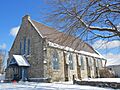
Wallingford Presbyterian Church
This Presbyterian church is located where Brookhaven Road and Avondale Road meet.
Greater Philadelphia Baptist Church
This church building was formerly Zion African Methodist Episcopal. The Greater Philadelphia Church moved into it in 2015. It's in South Media at Manchester Ave. and Wallingford Ave.
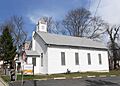
Leiper Church
The historic Leiper church is on Fairview Road. In 2015, it became home to Holy Myrrh Bearers Ukrainian Catholic church.
Neighborhoods to Explore
Nether Providence has several distinct neighborhoods, each with its own charm.
Bowling Green
Bowling Green is a neighborhood with detached houses. It's north of Baltimore Pike and borders Media Borough. Streets here include Mulberry Lane, Bent Road, and Surrey Road.
Pine Ridge
Pine Ridge is another neighborhood with detached houses, also north of Baltimore Pike. Streets like Hemlock Road and Pine Ridge Road are found here. Even though it's in Nether Providence, students from Pine Ridge go to Swarthmore-Rutledge School.
Wesley Manor
Wesley Manor is a neighborhood of detached houses located north of Baltimore Pike. Streets in this area include Meredith Drive and Springlawn Drive.
Sproul Estates
Sproul Estates features detached houses north and west of Bullens Lane. It's named after William Cameron Sproul, who used to live there.
Famous People from Nether Providence
Some notable people have connections to Nether Providence Township:
- Horace Howard Furness
- William Henry Furness III
- Horace H. F. Jayne
- Thomas Leiper
- Albert Cook Myers
Images for kids
-
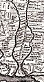
1687 Holme Map showing Providence Road
-
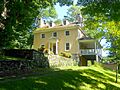
"Avondale," Thomas Leiper Estate
-
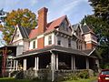
West Lawn, a historic home
-
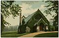
Wallingford Presbyterian on an old postcard
-
The Greater Philadelphia Baptist Church, formerly Zion AME
-
The former Leiper Presbyterian Church
-

I-476 "Blue Route" northbound in Nether Providence Township


_from_the_overpass_for_Plush_Mill_Road_in_Nether_Providence_Township,_Delaware_County,_Pennsylvania.jpg)
See also
 In Spanish: Municipio de Nether Providence para niños
