Garner, North Carolina facts for kids
Quick facts for kids
Garner, North Carolina
|
||
|---|---|---|

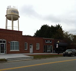
Downtown Garner Water Tower over East Main Street
|
||
|
||
| Motto(s):
"A Great Place to Be"
|
||

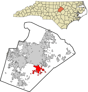
Location in Wake County and the state of North Carolina.
|
||
| Country | United States | |
| State | North Carolina | |
| County | Wake | |
| Incorporated | 1905 | |
| Government | ||
| • Type | Council–Manager | |
| Area | ||
| • Total | 18.32 sq mi (47.44 km2) | |
| • Land | 18.27 sq mi (47.32 km2) | |
| • Water | 0.05 sq mi (0.12 km2) | |
| Elevation | 325 ft (99 m) | |
| Population
(2020)
|
||
| • Total | 31,159 | |
| • Density | 1,705.38/sq mi (658.44/km2) | |
| Time zone | UTC−5 (EST) | |
| • Summer (DST) | UTC−4 (EDT) | |
| ZIP code |
27529
|
|
| Area code(s) | 919 | |
| FIPS code | 37-25480 | |
| GNIS feature ID | 2406547 | |
Garner is a town located in Wake County, North Carolina, in the United States. It's like a neighbor to the bigger city of Raleigh. In 2020, about 31,159 people lived here.
Even though Garner is mostly in Wake County, some nearby areas also use a Garner mailing address. This includes parts of unincorporated Wake County and the Cleveland community in Johnston County. Garner is part of the Research Triangle region, which is known for its universities and technology companies. Many people who live in Garner work in other parts of this region.
Contents
Where is Garner Located?
Garner is entirely within Wake County. The town covers about 18.32 square miles (47.44 square kilometers). Most of this area is land, with a small amount of water.
Some areas outside the official town limits also have Garner addresses. This includes parts of Wake County and Johnston County.
How Many People Live in Garner?
Garner has grown a lot over the years! Here's how the population has changed:
| Historical population | |||
|---|---|---|---|
| Census | Pop. | %± | |
| 1910 | 284 | — | |
| 1920 | 376 | 32.4% | |
| 1930 | 476 | 26.6% | |
| 1940 | 768 | 61.3% | |
| 1950 | 1,180 | 53.6% | |
| 1960 | 3,451 | 192.5% | |
| 1970 | 4,923 | 42.7% | |
| 1980 | 10,073 | 104.6% | |
| 1990 | 14,967 | 48.6% | |
| 2000 | 17,757 | 18.6% | |
| 2010 | 25,745 | 45.0% | |
| 2020 | 31,159 | 21.0% | |
| U.S. Decennial Census | |||
Garner's Population in 2020
In 2020, there were 31,159 people living in Garner. These people lived in 11,642 households, with 7,637 of them being families.
The town is home to people from many different backgrounds. Here's a look at the racial makeup of Garner in 2020:
| Race | Number | Percentage |
|---|---|---|
| White (non-Hispanic) | 15,905 | 51.04% |
| Black or African American (non-Hispanic) | 9,163 | 29.41% |
| Native American | 132 | 0.42% |
| Asian | 681 | 2.19% |
| Pacific Islander | 17 | 0.05% |
| Other/Mixed | 1,468 | 4.71% |
| Hispanic or Latino | 3,793 | 12.17% |
A Look at Garner's History
The area around Garner was first settled around 1751. In the 1850s, a railroad was built through the region. This led to a stop being created in what is now downtown Garner. This stop was called Garner's Station.
The community officially became a town in 1883. However, its town status was removed in 1891. Luckily, in 1905, Garner became a town again! The first mayor was J.B. Richardson.
In 1912, the telephone came to Garner, connecting people in new ways. A major road, US 70, was built through the town in 1917. It was the first paved highway in North Carolina.
Some important historic places in Garner are listed on the National Register of Historic Places. These include the Downtown Garner Historic District, Edenwood, and Meadowbrook Country Club.
Where Do People Work in Garner?
Garner has many different types of jobs. Here are some of the biggest employers in the town:
| # | Employer | # of Employees |
|---|---|---|
| 1 | Wake County Public School System | 1,280 |
| 2 | Pepsi Bottling Ventures | 400 |
| 3 | Walmart | 350 |
| 4 | Lowe's Home Improvement | 335 |
| 5 | Sigma Electric Mfg Corp | 300 |
| 6 | Target | 290 |
| 7 | Hamlin Company | 250 |
| 8 | Food Lion | 220 |
| 9 | Ameri Gas | 198 |
| 10 | Town of Garner | 170 |
In 2020, a large Amazon warehouse opened in Garner. It is expected to create many new jobs for the area.
Getting Around Garner
Roads and Highways
Several important roads and highways help people travel in and out of Garner:
- Interstate 40 runs near Garner. You can get to the town from several exits.
- U.S. 70 is the main east-west highway. Many businesses and shopping centers are located along this road.
- U.S. 401 and N.C. 50 also pass through or near Garner.
- N.C. 42 is south of Garner and serves many nearby areas.
- Local roads like Timber Drive and Garner Road help connect different parts of the town.
Buses and Public Transport
Garner has bus services provided by GoRaleigh. Routes 7 and 40x serve shopping areas. Route 20 connects downtown Garner to downtown Raleigh and other important spots like the Town Hall and libraries.
There's also a special service called GoWake Access. It helps seniors and people with disabilities get around if they can't use regular buses.
Trains and Air Travel
While Amtrak trains pass through Garner, they don't stop there. The closest train station is in Raleigh.
For flying, the nearest big airport is Raleigh-Durham International Airport. Smaller airports for private planes are also nearby.
Schools in Garner
Students in Garner attend schools that are part of the Wake County Public School System. Some schools are within Garner's town limits, while others are close by.
Here are some of the schools that serve students in and around Garner:
- Aversboro Elementary School
- Bryan Road Elementary School
- Creech Road Elementary School
- East Garner Elementary School
- Rand Road Elementary School
- Smith Magnet Elementary School
- Timber Drive Elementary School
- Vandora Springs Elementary School
- Vance Elementary School
- East Garner Middle School
- North Garner Middle School
- Garner Magnet High School
- South Garner High School
Some students in areas with Garner addresses attend schools in Johnston County:
- Polenta Elementary School
- West View Elementary School
- Cleveland Middle School
Famous People from Garner
Many talented people have come from Garner, North Carolina! Here are a few:
- Brandon Banks, a wide receiver and return specialist in the Canadian Football League.
- Chris Culliver, an NFL cornerback.
- Nyheim Hines, an NFL running back.
- Scotty McCreery, the winner of American Idol season 10.
- John Wall, an NBA player.
- David West, an NBA player.
See also
 In Spanish: Garner (Carolina del Norte) para niños
 | James B. Knighten |
 | Azellia White |
 | Willa Brown |


