Geham facts for kids
Quick facts for kids GehamQueensland |
|||||||||||||||
|---|---|---|---|---|---|---|---|---|---|---|---|---|---|---|---|

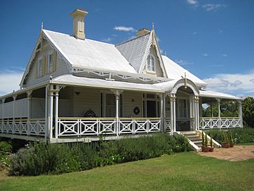
Argyle Homestead, 2009
|
|||||||||||||||
| Population | 470 (2021 census) | ||||||||||||||
| • Density | 9.92/km2 (25.7/sq mi) | ||||||||||||||
| Postcode(s) | 4352 | ||||||||||||||
| Area | 47.4 km2 (18.3 sq mi) | ||||||||||||||
| Time zone | AEST (UTC+10:00) | ||||||||||||||
| Location |
|
||||||||||||||
| LGA(s) | Toowoomba Region | ||||||||||||||
| State electorate(s) | Condamine | ||||||||||||||
| Federal Division(s) | Groom | ||||||||||||||
|
|||||||||||||||
Geham is a small country area in the Toowoomba Region of Queensland, Australia. In 2021, about 470 people lived there.
Contents
Exploring Geham's Landscape
Geham is surrounded by nature. To the north and north-west, you'll find Cooby Creek. To the west is the Cooby Creek Reservoir, also known as Lake Cooby. This lake holds water from the creek.
Mountains and Roads
The famous Great Dividing Range passes through the south-east part of Geham. However, there are no named peaks of this range right within Geham. Cooby Mountain is in the west. It stands about 619 meters (2,031 feet) tall. This mountain is not part of the Great Dividing Range.
The New England Highway is a major road that goes through Geham. It enters from the north-west and leaves towards the south.
Parks and Forests
Even though they have "Geham" in their names, Geham National Park and Geham State Forest are actually in nearby areas. The National Park is in Mount Luke. The State Forest is in Mount Luke and Merritts Creek.
Land Use and Climate
Most of the land in Geham is used for farming. This includes raising animals like cattle and growing crops. There are also areas with forests used for timber.
Geham has two main types of climate. The northern part has a humid subtropical climate. This means it's usually warm and humid. The southern part has an oceanic climate. This climate is milder, with cooler summers and warmer winters. Geham is special because it has the most northerly oceanic climate in Australia at a higher altitude.
A Look Back at Geham's History
Geham has a rich history with its post office, schools, and churches.
Post Office and School Beginnings
The first post office in the area opened in 1868. It was first called Highfields Post Office. In 1876, its name was changed to Geham.
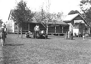
Highfields No. 2 State School opened its doors on April 4, 1871. It started with 47 students. John O'Beirne was the first headmaster. Just like the post office, the school was renamed Geham State School in 1876. In 2021, the school celebrated its 150th birthday!
Early Churches in Geham
The Geham Presbyterian Church first opened on September 8, 1878. It was built from wood on land given by Mrs. Black. The church building was moved and rebuilt in 1926.
Holy Trinity Anglican Church opened on October 16, 1887. It was officially dedicated a few years later. This church building was sold in 2019. It is located on Pioneer Road, but its main entrance was on Connolly Road. The old church building is still standing today.
Important Places in Geham
Geham has some special places that are protected because of their history.
Heritage-Listed Sites
One of these important places is Argyle Homestead. It is located on the New England Highway. This homestead is recognized for its historical value.
Learning and Education in Geham
Geham has a primary school that helps young students learn and grow.
Geham State School
Geham State School is a government primary school for students from Prep to Year 6. It teaches both boys and girls. The school is located at 9625 New England Highway. In 2017, about 140 students attended the school.
Secondary Education Options
There are no high schools directly in Geham. Students who finish primary school usually go to high schools in nearby towns. The closest government high schools are Highfields State Secondary College in Highfields and Crows Nest State School in Crows Nest.
Community Life in Geham
Geham has places where the community can gather.
Local Amenities
The Geham Presbyterian Church is an important community building. It is located at 9621 New England Highway, right next to the school.
 | Shirley Ann Jackson |
 | Garett Morgan |
 | J. Ernest Wilkins Jr. |
 | Elijah McCoy |


