Groomsville, Queensland facts for kids
Quick facts for kids GroomsvilleQueensland |
|||||||||||||||
|---|---|---|---|---|---|---|---|---|---|---|---|---|---|---|---|

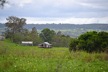
View over farmland at Groomsville looking east towards Pechey Forestry from Green Acres Road, 2015
|
|||||||||||||||
| Population | 132 (2021 census) | ||||||||||||||
| • Density | 2.218/km2 (5.74/sq mi) | ||||||||||||||
| Postcode(s) | 4352 | ||||||||||||||
| Elevation | 450–720 m (1,476–2,362 ft) | ||||||||||||||
| Area | 59.5 km2 (23.0 sq mi) | ||||||||||||||
| Time zone | AEST (UTC+10:00) | ||||||||||||||
| Location |
|
||||||||||||||
| LGA(s) | Toowoomba Region | ||||||||||||||
| State electorate(s) | Condamine | ||||||||||||||
| Federal Division(s) | |||||||||||||||
|
|||||||||||||||
Groomsville is a small countryside area in Queensland, Australia. It is known as a "locality," which is like a small district or neighborhood. Groomsville is part of the Toowoomba Region and is located on the Darling Downs. In 2021, about 132 people lived there.
Contents
Exploring Groomsville's Geography
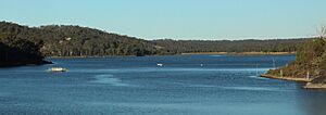
Groomsville is surrounded by natural features. To the south-east, you'll find Cooby Creek. This creek also forms the southern border, where it flows into the Cooby Creek Reservoir. This reservoir is a large lake created by the Cooby Dam. The creek then continues beyond the dam to the south-west.
Two main roads cross through Groomsville. The Pechey-Maclagan Road runs from the north-east to the north-west. Groomsville Road goes towards the south-east. Most of the land in Groomsville is used for grazing. This means farmers let animals like cows or sheep eat the natural plants growing there.
A Look at Groomsville's History
Groomsville has a simple but interesting history.
Early Schools in Groomsville
A school first opened in the area on May 29, 1906. It was called Jericho Estate Provisional School. A "provisional school" was a temporary school, often set up in new or small communities. In 1908, its name changed to Groomsville Provisional School. Then, on January 1, 1909, it became Groomsville State School, meaning it was a permanent government school. However, the school eventually closed its doors in 1951. The old school was located at 845 Pechey Maclagan Road.
Building Cooby Dam
An important part of Groomsville's history is the construction of Cooby Dam. This dam was built between 1938 and 1941. Once finished, the Cooby Creek Reservoir became the very first source of drinking water for the city of Toowoomba.
Who Lives in Groomsville?
We can learn about the people living in Groomsville from official counts called censuses.
- In 2016, the population of Groomsville was 113 people.
- By 2021, the number of people living in Groomsville had grown slightly to 132.
Education Opportunities Near Groomsville
Groomsville itself does not have any schools. Students living in the area travel to nearby towns for their education.
Primary Schools Nearby
For primary school (kindergarten to Year 6), children can attend:
- Geham State School in the neighboring area of Geham (to the south-east).
- Goombungee State School in Goombungee (to the west).
- Crows Nest State School in Crows Nest (to the north-east).
Secondary Schools Nearby
For secondary school (Year 7 to Year 10), the closest government school is Crows Nest State School. For older students (Years 11 and 12), the nearest government secondary school is Highfields State Secondary College in Highfields (to the south).
Fun and Facilities in Groomsville
Even though Groomsville is a small rural area, it offers a place for outdoor activities.
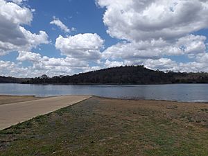
Cooby Dam Boat Ramp
There is a boat ramp that leads into the Cooby Creek Reservoir. This ramp is located on Cooby Dam Road. While the boat ramp is technically within Groomsville, you need to go through the nearby areas of Meringandan or Kleinton to reach it. The Toowoomba Regional Council manages this boat ramp, making sure it's safe and ready for use.
 | Ernest Everett Just |
 | Mary Jackson |
 | Emmett Chappelle |
 | Marie Maynard Daly |


